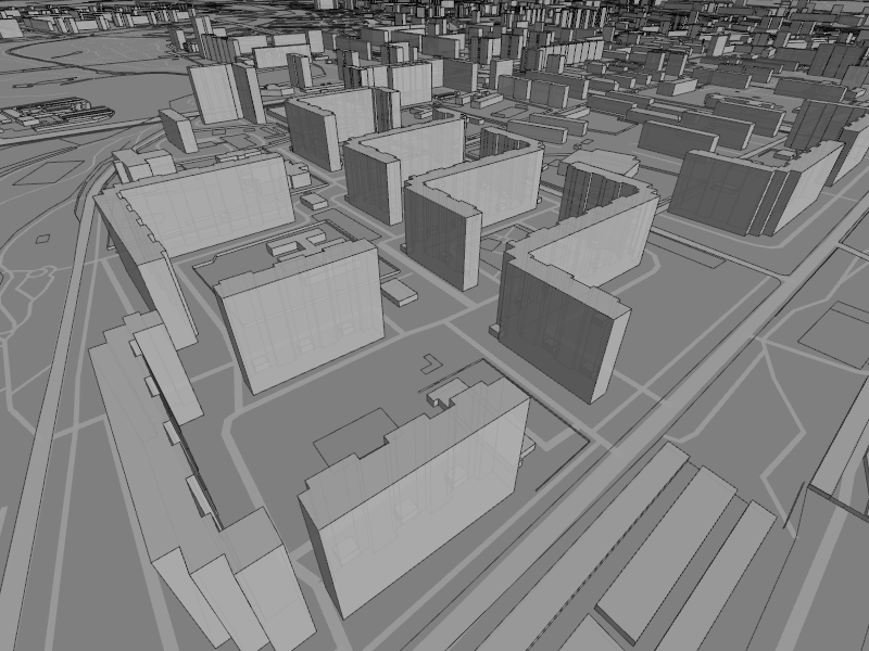
glosm is a
hardware-accelerated OpenGL-based OpenStreetMap renderer, producing 3D
renderings like this one of an area of Moscow
If you know another image of similar quality, you can nominate it on
Featured image proposals.
glosm is a
hardware-accelerated OpenGL-based OpenStreetMap renderer, producing 3D
renderings like this one of an area of Moscow
If you know another image of similar quality, you can nominate it on
Featured image proposals.
Has the weather looked a bit monochromatic lately? Let’s brighten
things up a bit by mapping something colorful. How about a flower
shop? Flowers, bouquets, corsages and arrangements for events are
available from a florist shop.
http://wiki.openstreetmap.org/wiki/Project_of_the_week/2011/Feb_09
This is your Project of the Week. Make suggestions. Inspire other
mappers. What is it about contributing to OpenStreetMap that
interests you? Postboxes? Bowing alleys? Share your OpenStreetMap
interests by contributing a Project of the Week.
http://wiki.openstreetmap.org/wiki/Project_of_the_week/Proposals
Florist photo by Lenore Edman http://www.flickr.com/photos/lenore-m/
is licensed CC-By http://creativecommons.org/licenses/by/2.0/deed.en_CA
There is an interesting story about the neon florist sign.

University of Delaware has rolled out a campus map that is based on
OpenStreetMap.
This is a Featured image, which means that it has been identified as
one of the best examples of OpenStreetMap mapping, or that it provides
a useful illustration of the OpenStreetMap project.
If you know another image of similar quality, you can nominate it on
Featured image proposals.
First U.S. map purchased for record price
http://www.washingtonpost.com/wp-dyn/content/article/2011/01/30/AR2011013003337.html
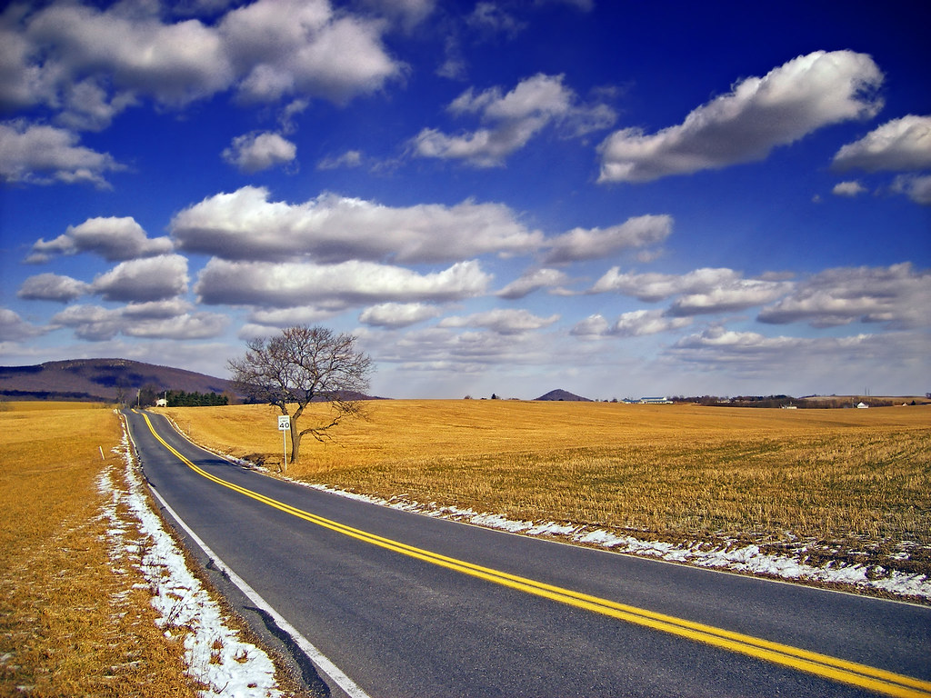
Steve Coast has been busy since his arrival at Bing a while back. They
have rolled out a neat, automated road finder service. Have a look at
the demonstration video here:
http://magicshop.cloudapp.net/
And the announcement and more details here:
http://www.bing.com/community/site_blogs/b/maps/archive/2011/02/03/automatica…
Road image by Nicholas_T http://www.flickr.com/photos/nicholas_t/
is licensed CC-By http://creativecommons.org/licenses/by/2.0/deed.en_CA

It was a magical place when we were younger. A place full of sweet
scents, that lead to sticky fingers and perhaps a bit of stray sugar
on a cheek. It was exciting to be going there and disappointing to
have to leave.
You can make an excuse to revisit that place of happy memories, new
flavor discoveries and a tiny little bit of sugar-inspired energy.
The Project of the Week is to map your local candy store. Find out
how to add your local candy store to the map, and watch the results as
other mappers do the same.
http://wiki.openstreetmap.org/wiki/Project_of_the_week/2011/Feb_02
This is your Project of the Week. Make suggestions. Inspire other
mappers. What is it about contributing to OpenStreetMap that
interests you? Postboxes? Bowing alleys? Share your OpenStreetMap
interests by contributing a Project of the Week.
http://wiki.openstreetmap.org/wiki/Project_of_the_week/Proposals
Candy display photo by http://www.flickr.com/photos/ume-y/
is licensed CC-By-SA http://creativecommons.org/licenses/by-sa/2.0/deed.en_CA
01/19/2011 – 02/01/2011
Every week a lot of things are happening in the OpenStreetMap (OSM) world. It can be hard to keep track of all the different communication channels and don’t miss any important news. That’s why we’ve created a short summary of all the news here. Enjoy! (Sorry, we couldn’t keep the weekly schedule because we’re still only two authors who are busy with other stuff too 🙁 )
For more news, especially regarding new tags and wiki pages, you can check-out the community-updates over here.
Authors: Pascal & Jonas
We missed something? You want to help us collecting the news for next week’s issue?
You can contact us via mail or Twitter.

Municipality council using Nicolas Dumoulin’s OSM-based map of
potential flood, fire, cave-in hazards in a town.
This is a Featured image, which means that it has been identified as
one of the best examples of OpenStreetMap mapping, or that it provides
a useful illustration related to the OpenStreetMap project.
If you know another image of similar quality, you can nominate it at

The State of the Map Call for Sponsors has been open for a little while. You’ll remember that SotM is Absolutely The Place for cool mappers to meet and greet and share their OpenStreetMap-py experiences. If you want your company to have a sponsorship presence at SotM, contact the State of the Map team.
And the SotM organizing committee has been busy. They have announced that the first sponsor for SotM 2011 is [drum roll please]

MapQuest is thrilled to sponsor the 2011 State of the Map conference in Denver. The power of open-source mapping unlocks the next wave of innovative LBS apps and we are excited to support OSM’s goals to accelerate growth of the worldwide mapping community
— Christian Dwyer, SVP & GM, AOL/MapQuest
MapQuest is a returing sponsor for State of the Map. They first joined us last year in Girona. I enjoyed meeting some of the MapQuest Open Initiative team last year and I know that you are going to enjoy getting to know them this year.
Okay, State of the Map team, now I really want to book my ticket! When can I do that? 😉

Adding buildings to OpenStreetMap has been difficult in the past.
Collecting a GPS trace of a building yields poor results because the
building interferes with GPS reception. But buildings can be
interesting to have on a map. Large collections of buildings in cities
can look very impressive. Lone buildings in remote areas can be
important landmarks for navigation. Or a shelter from bad weather.
There are more than 28 million buildings in the OpenStreetMap
database. Recent donations to OpenStreetMap contributors of aerial
imagery that permits deriving OSM objects without restriction have
made mapping buildings practical in more parts of the world.
The Project of the Month for February is to add local buildings to the map.
http://wiki.openstreetmap.org/wiki/Project_of_the_week/2011/Jan_26
This is a Project of the Month. Project of the Week returns
next week, while PotM will continue until the end of February. These projects
inspire mappers to contribute data they might not have considered
previously, and allow us to be inspired by the projects of other
mappers.
This is your Project of the Month. Make suggestions. Inspire other
mappers. What is it about contributing to OpenStreetMap that
interests you? Postboxes? Bowing alleys? Share your OpenStreetMap
obession by contributing a Project of the Month.
http://wiki.openstreetmap.org/wiki/Project_of_the_week/Proposals
Timber framed building photo by WikiMedia user Gerbil
http://commons.wikimedia.org/wiki/User:Gerbil
is licensed CC-By-SA
http://creativecommons.org/licenses/by-sa/3.0/deed.en