Category Archives: Uncategorized

WIN a FREE trip to State of the Map 2011!

Starting today you have an awesome chance to win a FREE trip to State of the Map in Denver!

Create a fun and unique video about what OpenStreetMap means to you and why you should be chosen and you could be the lucky winner!

Here are the details:


OpenStreetMap Video Competition

Create a 1-3 minute video with the following criteria to guide you:

1. The video should be fun, unique and show what OpenStreetMap means to you.

2. Explain why we should choose you to be at State of the Map 2011!

3. Normal necessities and niceties:

No vulgar language

No nudity

No animal cruelty

4. Video must have CC, CC-BY or CC-BY-SA licensing

5.  Post your video to YouTube.com with the hash symbol: #sotm11

6. Email your submission (plus link to video) to video@stateofthemap.org.

Hint: Promote your video on twitter, blogs, FaceBook, etc to get more views!

The competition is open now until July 8th, 2011 11:59pm PST.

Winner will be announced by July 15th, 2011.

Winner will be chosen by a combination of video popularity and by the SotM organizing committee.

Enter as many times as you like!

No purchase necessary.

*Free trip includes round-trip flight, hotel for three nights and one (1) Passport ticket to State of the Map 2011.


Scholarships available to State of the Map 2011

Today the State of the Map committee announced a program to cover full travel and accommodation costs for mappers to attend State of the Map 2011 in Denver, Colorado (United States).

More information about scholarships can be found on the State of the Map website and the OSM wiki page

Here are the general guidelines: 

 *candidates should be from places where costs would prohibit attendance, developing countries and places that are “interesting” geopolitically. 

 *ideal candidates for funding are from countries with a small OSM community, perhaps just a few mappers in total.

*nominees have made a significant start at mapping their city, either through imagery or with their own GPS, and are directly familiar with the process of OSM. They may have started communicating among themselves, and made plans and scoped out the process for their local district. But, the community is nowhere near critical mass, and they need the inspiration and support to take OSM to the next level.


Nominations should be sent to scholarship@stateofthemap.org. For each nomination, include the mappers name, OSM user name, email address, location, and a paragraph or two on why they’d be great to have at SOTM. Self nominations are accepted.

The nomination period is open until June 25th and the number of scholarships rewarded will be based on the success of fund-raising. You can also be part of the Sponsor-a-Mapper program, to help fund deserving mappers to attend State of the Map. 


Project of the Month: Education Month

The theme for Project of the Month during June 2011 is education.
We’ll map the places that we associate with educating ourselves and
others. Is the primary school that you attended included in
OpenStreetMap? Your high school? Add those places to the map. We’ll
look at post-secondary schools and other places associated with
education as the month progresses.

During the course of the month, we’ll be adding local primary and
secondary schools. You’ll find guidelines on how to map schools on the wiki.

The classroom photo is by Liz (perspicacious.org) and it is licensed CC-By

Weekly OSM Summary #18

May 16th, 2011 – May 30th, 2011

A summary of all the things happening in the OpenStreetMap world.

  • The email for users, who didn‘t accept the new Contributor Terms so far, is ready now. It should be translated in as many languages as possible. A first batch of emails has already been send out now.
  • Blog post by Patrick Weber about “Where’s the Search” field on the OpenStreetMap.org main page. Maybe as a result of this post, the search field has now been moved to an upper left position on the main OSM page.
  • Muki Haklay repeats the comparison for the UK between the OSM and Ordnance Survey Meridian 2 datasets. You can find an interactive webpage with the results here.
  • We now have more then one million relations in our database!
  • Open Data in Vienna is now available and the first application is out: The Toilet Map Vienna. An Augmented-Reality-App based on Open Data from Vienna.
  • A new mailling list for the OpenStreetMap Foundation (OSMF) is available.
  • The OSMF-Wiki has a new skin made by Harry Wood. This way you can differentiate it from the normal OSM wiki.
  • Jakob Altenstein wrote a bachelor-thesis about the efforts of the OSM license change. It is available in German here.
  • A new series shows how communities from different countries map around the world.
  • Pascal Neis wrote a blog post about the new Web-GUI for the Open Source Routing Machine (OSRM) with OSM data.
  • Some thoughts from Olvier Kühn about “Could a less restrictive share-alike license give OpenStreetMap data a boost?
  • Steve Coast pleads for moderation of the OSM mailing lists.
  • First preliminaries for the change from 32bit to 64bit node IDs.
  • The first tour guide with OSM maps has been published. It is available for ten cities along the Danube. You can find more information in German here and a screenshot here.
  • OSM user “Head” created a haptomap with OSM.
  • The project “building=yes” is a searchable directory for all buildings of the OSM database.
  • Chris Hill wrote about his first impressions with Leaflet (an OS JavaScript library for making tile-based interactive maps for mobile/desktop browsers) und created a demo.
  • A map by Magnificent shows areas a user can reach using public transport in a given time for certain cities.
  • Employees of the Westfälische Wilhelms-Universität Münster hosted an OpenStreetMap Mapping Party in São Paolo with 40 students. (Link is in German)
  • Harry Wood wrote a summary of the last London Hack Weekend.
  • Tim Adler published a usage statistic for the Wikipedia POI Layer here.
  • A first GSoC project update from Customised OSM Tile Server and request for feedback.
  • Martijn van Exel would like to start a new OSM service (for example with twitter) and includes some ideas about anonymous edits.
  • A book about OpenLayers 2.10 has been published.
  • TileMill’s latest version supports PostGIS and can render from an OSM database.
  • Blog Post by Mike Dobson about “examining Google Map Maker and how its edit and authority systems function“. Part one and part two.

Did we miss something? You can contact us via mail.

OSM mailing lists: time for a change?

OSM has had a good run with our mailing lists, especially if you grade that based on quantity. We have over 100 of them for Iranians to Australians, for importers to newbies.

The problem is that they’re an echo chamber. Every mail is sent to everyone. That means intelligent postings as well as complete garbage get the same precedence and everything is equally loud.

Unfortunately some of the main lists have become less than nice places to be. Low signal to noise and a scorched earth policy from the more flamey participants pushes people away.

Below: Newbies prepare to enter talk@openstreetmap.org

Alien-movie-spacesuits1

Let’s look at some solutions. One is to get rid of them. We spend too much time worrying about this crap, just kill talk@ and move to a new list discuss@ or something. Let that list have a clear and simple etiquette policy list. Put someone in charge of kick/banning people who don’t play nice. The problem here is there are very few people willing to take responsibility for being the moderator. It’s unpaid, nobody will be nice to you (except me, obviously) and it’s hard work.

Below: Mailing list infestation marines prepare to nuke the talk@ list from orbit, because it’s the only way to be sure.

Aliens-vs-predator-players-wanted-20090526000151286-0001

Another is that we let the talk@ list be. All the clueful people decamp to a new list with a nice policy as above. Stop linking to talk@ and leave the bozos there. Hopefully they don’t notice.

Below: a newbie after making a polite suggestion on legal-talk@

Aliens-half-synthetic1

We could all migrate (one imagines this follows a sea parting) to the forums. There we could be safe for awhile. Newbies are more at ease in forums. It’s easier to delete posts, they don’t have the same permanence that a mailing list does: Forever in the archive, and already sent to all participants.

None of these options are easy and we can just vote with our feet.

There is an interesting technical solution possible though. Take the forum mechanics to a mailing list. So instead of every post going to every participant just send it to participants with high karma. If they like the post (either explicitly by clicking/emailing something, or implicitly by not doing anything) then it goes to others on the list. That list can have override features so I can get sent everything in a thread or block certain people. I’ve actually started building something like this but it’s too big to fit in the margin.

Below: calm arrives at talk@ during a license discussion, unicorns descend from the skies and free healthcare for all

Seeking_utopia_11

Before utopia arrives, Steve’s top tips for the mailing lists are as follows

  • Stop asking permission on the lists, you will never get it
  • Don’t feed the trolls
  • Clueful people post more, and more cluefully to drown out said trolls
  • Someone should be appointed to moderate the lists and just warn, kick and then ban people who aren’t nice. Just use common sense to identify who they are

Weekly OSM Summary #17

May 3th, 2011 – May 15th, 2011

A summary of all the things happening in the OpenStreetMap world.

  • OSM.org was updated with a refined changeset view. “When you view the history tab, you’ll now see a map with bounding boxes shown for recent changesets in the area. Hovering over the changeset will highlight the bounding box, and vice-versa.”
  • The OpenStreetMap Foundation has published guidelines for tile layers to be considered for inclusion on the OpenStreetMap web page.
  • The OSM tile server has been upgraded significantly after experiencing some performance problems due to high load by mobile apps that didn’t follow our Tile Usage Policy.
  • Since last week OSM has more than 400.000 registered members.
  • Henk Hoff has created a draft agreement for OSMF local chapters on the wiki and asked for input.
  • Emilie Laffray is stepping down from the OSMF board for personal and work reasons. The board appointed Oliver Kühn to the position of treasurer previously held by Emilie. The board will continue with six members until the next board election.
  • Early bird registration for State of the Map and FOSS4G is closing soon.
  • addr:housename is now rendered by Mapnik; here’s an example on the map.
  • MapCraft is a mapping party organizing tool with features like live chat, dividing the mapping area into slices and measuring the progress and more. (via Harry Wood’s Diary Entry)
  • Scottish OpenStreetMap ‘unconference’ – State Of The Map Scotland 2011. “Join the Scottish OpenStreetMap community to talk, workshop and hack for this two day event.”
  • OpenStreetBrowser version 2.0 is nearing release and is ready for some testing to find left bugs.
  • This WebGL globe shows you the volume of OSM edits around the world for the last 12 hours. (via @iandees)
  • OSM-3D also known as XNavigator developed by the University of Heidelberg has been released as open source.
  • The University of Munich has developed a new router specialised in looking at the wide variety of OSM tagging.
  • Version 0.9.6 of the WordPress OSM Plugin has been released.
  • Derick Rethans wrote a blog post about common misunderstandings regarding OpenStreetMap.
  • Pascal Neis added a few new features to “How did you contribute to OpenStreetMap ?”. You can now see how a user contributed the last 12 months. Further he created new stats for the OSM Inspector Routing View. You can find the complete analysis here.
  • “The Open Static Map Service [from MapQuest] enables the user to create beautiful static map images generated via an HTTP request for their website or publication.”
  • QualityStreetMap 2 is a web tool to document the progress made on mapping with aerial imagery or importing data for a given tile.
  • CloudMade released a new open source javascript library for interactive maps called Leaflet. It can be seen as an alternative to OpenLayers.
  • Peter Körner released a first batch of full-history extracts.
  • Mapnik2GeoTools is a small Scala tool with the goal of transforming Mapnik map definitions to something GeoTools and GeoServer can deal with.

Did we miss something? You can contact us via mail.

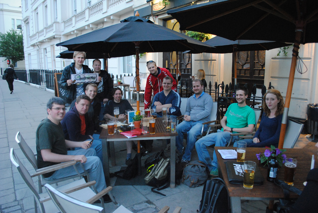
Image of the Week: London Summer Mapping Evenings 2011

Media_httpwikiopenstr_vbdgf

It is no accident that OpenStreetMap was founded in London, and that
the London OpenStreetMap community is so strong, so engaged and so
important to the everyday functioning and long term success of
OpenStreetMap. They meet often, they map often and they are
passionate about OpenStreetMap.

These are the faces behind many of the emails that you see on the OSM
lists, behind the code submissions that improve OSM and behind the
server racks adding another hard drive. Show us your local OSM group.
Add more faces to the OSM emails we read.

This is a Featured image, which means that it has been identified as
one of the best examples of OpenStreetMap mapping, or that it provides
a useful illustration of the OpenStreetMap project.

If you know another image of similar quality, you can nominate it on
Featured image proposals.

http://wiki.openstreetmap.org/wiki/Featured_image_proposals

Project of the Week: Sports centres

May 2011 is sport and activity month. The Project of the Month is to
map sport pitches in your area. Other sport and activity related
objects will be Project of the Week for the remainder of May.

A sports centre caters to several or many individual sports by
providing the infrastructure for participants in those sports. A
racquet sports centre might include playing courts for tennis, squash
and racquetball among others. A general sports centre might include a
multi-purpose gymnasium, outdoor fields for soccer, rugby, football
and baseball and indoor and outdoor courts for volleyball.

This week, we add sports centres to the map.

Sports centre photo by Battle Creek CVB is licensed