Author Archives: HarryWood

About HarryWood

Posting mostly in a Communication Working Group capacity (and often with text written collaboratively among CWG and others) About me on the OSM wiki

Disability Mapping with OpenStreetMap

Today is International Day of Persons with Disabilities.

We’re gathering map data related to disabilities within OpenStreetMap, and because the map is openly editable, you can help!

Edit the map of your neighbourhood to add details on wheelchair accessibility, and the presence of things like tactile paving for blind people. Details of the world which we may not imagine to be important, can be very useful things when presented on a map to help people with a variety of disabilities. We have OpenStreetMap “tags” for them all, from gluten-free food outlets, to more simple things like steps and toilets. It’s a lot of detail, but with thousands of people all mapping their own neighbourhoods we can map the world for disabled people.

A number of projects are delivering very interesting custom map applications, of a kind which would only be possible with free open access to raw geo-data:

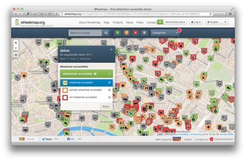
WheelMap.org provides a great interface into wheelchair accessibility data, presenting a traffic-light colour coding of accessibility, and inviting you to help categorise more map features in this way.

wheelmap-screenshot-en

Researchers at the University of Heidelberg have produced a prototype wheelchair routing service. This German language only service is available at rollstuhlrouting.de. The routing for wheelchairs takes into consideration maximum slope angle, the type of surface (e.g. cobbles vs asphalt) and the height of kerbs; all this information can be mapped and added to OpenStreetMap.

In France mappers conducted an extensive detailed mapping of accessibility features for railway stations, with funding from the french national railway company SNCF as part of their initiative to support open data. A talk by Christian Quest at our annual State of the Map (SOTM) conference, gives more details.

Also at the SOTM conference we had a talk about Haptomai, one of several experiments looking at supplying maps to blind people. Check out our OSM for the blind wiki page for links to other projects, and details of the kind of map contributions which can help.

Many of these projects are in the early stages of development, and welcoming new contributions to develop the ideas further. OpenStreetMap can offer a wealth of detailed data feeding into these innovations, but only in the neighbourhoods where this data has been added. So on International Day of Persons with Disabilities, there’s lots of interesting ways to help with OpenStreetMap!
New Humanitarian Style

We’ve added a new map style option to the OpenStreetMap front page. Feast your eyes on the new “Humanitarian” style:

This style has been developed by the Humanitarian OpenStreetMap Team to support their work, highlighting features they are most interested in, as well as just providing a contrasting stylisation of the map. The developer Yohan Boniface explains:

“OpenStreetMap data is as rich and varied as the real world. And, just as when you look through a window you can’t take in the whole world, so it is with a map based on OSM data: you can’t show it all. This is why we decided to provide the view from another window, through our own map and cartography, focusing on the world as seen through HOT’s community.”

“You may have noted that the colour scheme is light and pastel. This is certainly an aesthetic choice offering a nice contrast with the “standard” OpenStreetMap style. Consistency in the colour is also key to the readability of a map. But there was another goal for this. Now maps are everywhere, whether it is online or printed. But a generic map like the one we are building is generally only part of the message: whether it is online or printed, maps are often used with some custom data on top of them. For example, markers can be added to an online map to show specific points of interest. But also, more simply, they can be printed in order to draw on top of them. This could be details of a trip, a vaccination campaign, or additional map data when mappers are surveying. In all those situations, the map should do its job, providing geo information, but also leaving visual space for the main message.”

Read more about the new style on the HOT blog.

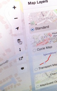
You can access this new style along with our other featured tiles any time you’re browsing the front page map, by clicking the layer icon on the right hand side.

Foundation AGM and board election results

The State of the Map conference in Birmingham is winding down (although today there’s a very lively room full of fifty OpenStreetMap hackers in way number 32637693) We’ll bring you a summary of all the SotM excitement soon. But before that… some OpenStreetMap Foundation business.

On Saturday we held the Foundation Annual General Meeting.

State Of The Map

Simon Poole, chairman of the board, conducted proceedings and gave his summary of the past year’s foundation news, and then we held a vote.

Board election results:

As Frederik announced on the mailing list, Dermot McNally and Oliver Kühn were both re-elected to the board. Congratulations to them. And they are joined by Kate Chapman.

Kate Chapman said in her manifesto: “Generally I would like to see the OSMF assist OSM in becoming more diverse, I think my experience through the Humanitarian OpenStreetMap Team (H.O.T.) can help make that happen”.   Welcome to the board Kate!

The vote counts looked like this:

  • Kate Chapman 114
  • Dermot McNally 85
  • Oliver Kühn 57
  • Roland Olbricht 54
  • Kai Krueger 42
  • Gregory Marler 40
  • Marek Strassenburg-Kleciak 13

Thank you to all of the candidates for taking part in this process.

Articles of Association

We also voted on adoption of new Articles of Association, and 92% voted in favour, and so this is accepted.

On the issue of whether to allow corporate members to vote, opinions were a little more divided. The count was: For:75; Against:59; Abstain:14. This means a 58% yes vote, and the target of 75% has not been reached, so the amendment is not accepted.

You can read a little more about the points discussed at the AGM, in the draft meeting minutes.

Last chance to vote by email

Today is your last chance to vote by email for this year’s foundation board elections. If you are a member of the OpenStreetMap Foundation, and you are not planning to vote at the annual general meeting in Birmingham this Saturday, then please read the proxy voting information and follow the instructions carefully to send a proxy vote request by email.

As well as voting for three board candidates, we are also asking members to vote on the Articles of Association. See Simon Poole’s previous blog post explaining this.

Proxy voting closes today at 22:00 UTC, but final votes will be accepted in person if you’re coming to Birmingham.

Two weeks until State Of The Map 2013

Just two weeks to go until “The State Of The Map“, the official annual conference of the OpenStreetMap project. If you haven’t been to one of these before, you’ve been missing out!

The State Of The Map conference offers something for everyone, with multiple streams of presentations, workshops and space for lively discussion on anything and everything to do with OpenStreetMap. It’s a joyful coming together of our friendly community, but also a serious period of concentrated discussion and idea sharing, and a promotional opportunity for your map-making and money-making endeavours. Whether you consider yourself a mapper, a cartographer, a developer, a GIS industry representative, a humanitarian, whether you like your maps on an iPhone, an Android, a Garmin, or a piece of paper, you’ll be in good company at State Of The Map!

sotm-bull

StateOfTheMap.org

The schedule of presentations and sessions is being finalised now. There will be the oppportunity to do a “lightning talk” at the conference (Just signup at the conference). Additionally there is the opportunity to display an A1 sized poster during the conference. It will even be printed for you, if you get the design to us within the next week. Get in touch about posters if this is of interest.

State Of The Map would not be possible without the generous support of our sponsors. Here’s the sponsors we have so far:

sotm-sponsors-2013-so-far

These organisations recognise the value of OpenStreetMap and choose to support it in this way because they are at the forefront of their industries, working with new mapping technologies. If you would like to see your company among them, there’s still time. Please get in touch.

See you in two weeks!

New map controls on OpenStreetMap.org

new front page controlsWe’ve just gone live with some changes to the map controls on the OpenStreetMap.org front page.

“Re-organise the map tools. Take them from all four corners and just put them together in a more organised way”, explained Designer Saman Bemel-Benrud in his SOTM U.S. presentation as he put forward this and many other ideas for front page design improvements.

As well as re-arranging things, you can now use browser geo-location to locate the map where you are (geolocate-icon), and the map layers picker (layers-icon) now gives a preview of the different map styles on offer (Those which we feature on the front page. There are many others of course)

We’re excited to unveil these changes which we think will improve the experience, particularly for new site visitors, and we will continue to make improvements in the coming months. Obviously if you’ve been using the OpenStreetMap website for some time, the re-arrangement may take some getting used to, but we hope you like it too!

Big thanks to John Firebaugh, Saman Bemel-Benrud, Tom MacWright who did the javascript development and design work for this with a healthy dose of feedback and collaboration from others. Many issues have already been discussed and weighed up, but if you have further feedback, the dev talk mailing list could be the best place for it. (Updated: discussion seems to be happening on the ‘talk’ mailing list)

State Of The Map – Register now for early bird prices

Tomorrow is the last day of May, and your last chance to grab yourself a “State Of The Map” conference ticket at the reduced “Early-bird” prices.

State Of The Map is the international annual conference of the OpenStreetMap foundation. There’s a lot of excitement about stateofthemap.us taking place in San Francisico in just over a week’s time. This is shaping up very nicely, and registration is still open. It is organised by OpenStreetMap U.S., and is followed by SOTM Baltics in August. Various other local chapters are running their own local conferences. ….but the main event….

State Of The Map is taking place in Birmingham, England. 6-8th September. A few months away, but book early to avoid disappointment (and save a bit of money). Register now!

There’s also an upcoming deadline for the call for presentations. A great opportunity to reach out to the OpenStreetMap community. Get your presentation ideas submitted there. We’d love to hear from you.

Fund-raising drive. Thank you Lokku

We kicked off a new donation drive a couple of weeks ago (at the same time as bringing you the new iD editor). We have a £40,000 target for some specific hardware upgrades, and since then we’ve seen tremendous support and good will directed at OpenStreetMap from people all over the world as the donations come in, bringing us up to 23% of the target at time of writing.

We’ve just received our first large donation from Lokku, pushing us forwards to the tune of £2500 . Thank you Lokku!

lokku ltd
 

Perhaps this will be the first of many larger donations from supporting companies. We’re very grateful to Lokku for kicking things off, and for all their support over the years. Lokku are the people behind Nestoria, #geomob london, and also (coming soon) OpenCage Data. You can catch up with them at the U.S. conference SOTM US, and OSMPlus.

If you would like to make a donation head over to…

>>> donate.openstreetmap.org <<<

There is additional information on the wiki about our plans for these funds, but essentially with the money raised, we’ll be making some new hardware purchases which are important and necessary to keep things running smoothly as we continue to see astounding growth of our community. More mappers contributing, and more end users seeing our maps.

1 million OpenStreetMappers

OpenStreetMap has just passed 1 million users! That’s a million people who have signed up on openstreetmap.org to join in with creating a free map of the world.

At first glance you may think that OpenStreetMap is a map. Those who know more will tell you that it’s actually a database; a flexible editable repository of free geospatial data. But above all OpenStreetMap is a community. A massive community in which people like you and me come together collaborate and help build this thing… and now there’s a million of us!

A massive community is what makes OpenStreetMap work. We need many people to sign up, and we need those people in every neighbourhood, in every corner of the globe, to chip in a little bit using our editing tools. In this way we have grown and progressed spectacularly throughout 2012. This wonderful video illustrates what a great year of map editing activity we had.

Who will join the OpenStreetMap community in 2013?