Author Archives: HarryWood

About HarryWood

Posting mostly in a Communication Working Group capacity (and often with text written collaboratively among CWG and others) About me on the OSM wiki

International Volunteer Day

Today is International Volunteer Day. OpenStreetMap is all about volunteers of course. It’s about people getting out there and mapping their neighbourhood. If we have enough people volunteering in this way (just a little of your time, and local knowledge) we’ll have a free map of the world in no time!

But did you know OpenStreetMap is made up entirely of volunteers? Sometimes people assume that OpenStreetMap is a commercial company alongside other map providers, but OpenStreetMap is something different. It’s an internet-based collaborative project. Not only the mappers, but the entire organisation is built and driven by volunteers in their spare time.

The people who develop the website and the map editing software
…all volunteers.

The people who maintain the servers and keep the database and map view operating smoothly
…all volunteers.

The people in the working groups of the OpenStreetMap Foundation
…all volunteers.

The people on the OpenStreetMap Foundation board
…all volunteers.

We do occasionally discuss the idea of paying people in various roles of the foundation, but as it stands at the moment OpenStreetMap is an entirely volunteer-driven organisation from top to bottom. We’ve got where we are through the hard work and dedication of people who give up their spare time to the project. Hats off to the volunteers of OpenStreetMap, and a very happy International Volunteer Day!
Learn how to get involved

New Australian caching server

Posted to the talk-au mailing list some news from Grant Slater and the sysadmin team:

Have you noticed faster tiles this week? Australia now has a map caching server located in Brisbane. The server is used to speed up the standard tile.osm.org “Mapnik” map style.

Browsing the map on http://www.openstreetmap.org/ should now be more responsive. This new server, named ‘bunyip’, first started providing tiles on Tuesday.

We thank Kris Amy for providing the server and hosting. Thank you, Kris!

If anyone experiences any issues or hiccups, please let me know.

Technical: 

Server specs are here

OpenStreetMap tile servers use GeoDNS (PowerDNS with Geo backend) to locate the closest tile server. The DNS regions / cache-server can be viewed here.

To check which server you are being directed to use the command:
nslookup tile.openstreetmap.org
or
dig tile.openstreetmap.org

Regards
Grant – Part of OSM sysadmin team


Apple Maps

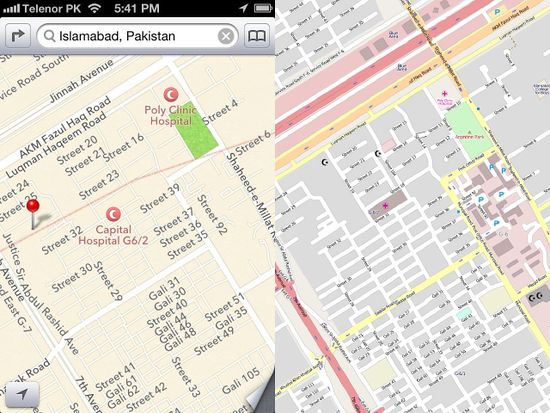
Apple’s new maps for iOS6 make use of OpenStreetMap in some parts of the world. We’re not sure how extensive this use is, but it’s fair to say they are mostly using other sources. Apple have used TomTom as a key supplier of data for example. This means that inaccuracies in apple maps are probably not the fault of OpenStreetMap (contrary to some commentary!) However OpenStreetMap is mentioned in apple’s credits, and we have spotted some areas where we think we can see our data in use. For example here in Islamabad:

We welcome Apple (or anybody else!) using our map data and we’d like to see them use it more.

If you are having problems with the maps on your phone, have a look at an app that only uses current OpenStreetMap data. That way, you’ll know the source. And if you find that the data in your area can be improved or updated, you can improve it! We hope you’ll join us and help make a free and open map of the world. There are so many OpenStreetMap powered apps (click here for a list). If you already have a favourite, please add a comment below to tell us which one it is, and why.

If you’re an iOS developer you can use an OpenStreetMap map within your app. You have a choice of several different libraries to do this: The open source route-me, or offerings from MapQuest or from CloudMade.

If you’re not an iphone user maybe you’re bored of all this apple talk. We do have apps for android and also windows mobile, blackberry, symbian and much more besides. Developers have brought our free and open data to many different mobile device platforms and navigation devices.

Whichever technologies you’re using to view maps, we hope you’ll choose free and open map data from the not-for-profit OpenStreetMap project.

New board members

As part of today’s activities in Tokyo, foundation members met for an Annual General Meeting where the final votes were cast for the board elections. Congratulations to our new board members:

Frederik Ramm, and Simon Poole.

Congratulations also to Henk Hoff who has been re-elected to his seat on the board. And thanks to Alex Barth, and Kate Chapman for running in the election. Excellent candidates all round, and we enjoyed some stimulating discussion and debate on the members mailing list. Let’s translate these ideas into action. Not only the elected board, but the whole foundation organisation (including you!) has a part to play in making 2012-2013 a great year for OpenStreetMap.

More details on the election

Remapping and data resolutions in progress

Since completing the worldwide automated redaction process, we’re seeing some great progress with remapping. Thanks to the efforts of the community we’re recovering a useable map in areas where large gaps had appeared. There is some scope for basic aerial imagery tracing in these areas. To join in with these remote mapping efforts you might like to check out rebuild.poole.ch, a tool to coordinate these efforts. Further details and other remapping tools / links are provided on the ‘Remapping’ wiki page

You are reminded that areas of data must not be copied from the pre-redaction CC-BY-SA licensed OpenStreetMap sources. Where users declined permission to carry their contributions forwards with the new license, we must respect these wishes. In cases where this has been ignored or remapping users have misunderstood, we must now resolve these issues. The Data Working Group and License Working Group are busy tackling this task at the moment. This has involved re-engineering some of the redaction code, and we are currently re-running some areas of data through a redaction process. Remapping work can be frustrating, but undoing remapping work is even more so, so please remember to treat pre-redaction data as a copyrighted source which cannot be input into OpenStreetMap.

Aside from this caution, it’s mapping as usual! Join in with the remote mapping efforts, and also remember that it’s as important as ever to welcome new members to our mapping community, to get more people all over the world mapping their own neighbourhoods. The license didn’t change yet, but all the work on filling in these gaps will soon be ODbL licensed, putting us on a secure footing for the future.

Vote for a new Foundation Board

 Today voting has been declared open for the changing seats on the OpenStreetMap Foundation board. Matt Amos, Richard Fairhurst, Dermot McNally, and Oliver Kühn will remain on the board, and are not required to re-run for election this time around, however we have three seats to vote on since Henk Hoff is re-running for election, Mikel Maron is stepping down, and Steve Coast will serve in a new position as “Chairman Emeritus”.

We have five candidates to choose from listed here and candidate nominations are now closed.

If you are a foundation member you can vote for three of these. You can vote by email, and voting is now open through until Wednesday September 5th. Please follow the instructions in the above link. Alternatively if you are going to be in Tokyo for State Of The Map, you may prefer to vote in person at the Annual General Meeting. If you are not a member there is still time to join the foundation before voting, but please do this as soon as possible to allow time for processing.

To help you decide who to vote for, each candidate has written a manifesto, linked from the above list. There is also some interesting debate on the osmf-talk mailing list, and if you wish, you can put questions to the candidates here.

Automated redactions complete

Over the past week the license change redaction bot has made automated redactions, sweeping across our entire worldwide dataset. The whole globe was covered yesterday. There has been substantial technical effort involved in developing and running the software to make those changes, and a fair degree of uncertainty about how long it would take, so this is a significant milestone. Congratulations and thanks are in order to all those who helped achieve it, and especially to Matt Amos, Andy Allan, Gnonthgol and MonkZ who carried out most of the coding work.

The data now in the live OpenStreetMap database is largely in a state where it can be declared ODbL licensed, however the license hasn’t changed yet. We will be posting a further update when this is imminent.

More than 99% of the data has been retained, and in most places, the difference is barely noticeable. There are, however, some areas of our map where the redaction was concentrated, in particular Poland and Australia. Though we would of course have preferred to retain this data, we do respect the original contributors’ decision, and we thank them for their past involvement in the project.

Fortunately the OSM community’s response in these areas has been magnificent and we believe we will be back to having a high-quality dataset in these areas in a short space of time. If, as an OSM mapper, you would like to help – by using aerial imagery and other sources, or ideally, from personal knowledge and survey – then please do get involved. Essentially we’re left with some new blank spots on the map, and can respond with the process we know and love. Use your favourite mapping techniques, go explore and fill in the blanks. (Note that you must not copy from CC-BY-SA datasets or map views based on the pre-redaction data; please treat this like you would any other incompatibly copyrighted map data.) We can begin this process in earnest now while final preparations for license changeover are made.

Redactions progressing well

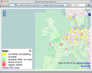
In the past week the redaction bot has progressed well. After the intial Ireland test, it has proccessed the UK and is now finishing off the ‘Western Europe’ area. Spain, and Italy are fully proccessed, France is very nearly complete, and the bot is (at time of writing) getting to work on some densely mapped regions such Germany and the Netherlands. You can see its progress on the redaction bot progress map

As you’ll see, the internal checks of the bot and the API occasionally throw up errors which cause a region (1 degree square) not to be fully processed. The developers working on the bot managed to track some of these failures down to specific bugs, meanwhile others are caused by temporary glitches in the API. The bot has been re-run in several areas for this reason.

You’ll also notice many yellow “current” regions being processed. These are parallel instances of the bot processing code. Although we’re not really in a hurry, we have a big dataset to get through. Running in parallel like this is proving to be a little faster.

There is still time to perform remapping ahead of the bot reaching your part of the world, though you may wish to refrain from editing in a region where the bot is actually runnning, to avoid any unnecessary complications. If you’re in a green area there is now a new kind of remapping to do. This is easier and clearer in many ways. Head out and remap those patches where the bot has redacted data.

Remember the license has not changed yet. Even in areas where processing is complete and redactions have been made, the license remains the same until we declare otherwise.

Follow the rebuild mailing list for more details and discussion.

Licence redaction ready to begin

Hello all,

I’m pleased to announce that the licence change bot is ready to get underway.

Starting this week, we will be ‘redacting’ the contributions (less than 1%) from the live database that are not compatible with the new Contributor Terms and Open Database Licence (ODbL) – in other words, they will no longer be accessible. We are expecting to begin on Wednesday (11th July) assuming a couple of final setup details are completed by then.

The bot will run in the following order:

  1. Ireland
  2. UK
  3. Western Europe
  4. North America
  5. Australia
  6. rest of the world

Once it is complete, we will be ready to distribute data under the ODbL and we’ll advise of that with a separate announcement. The final pre-redaction dataset available under CC-BY-SA has now been generated at http://planet.openstreetmap.org/planet-120704.osm.bz2 . Where data has been redacted, any attempt to access it from the API or the site’s ‘browse’ pages will return a response to that effect.

Test runs have shown that the bot is functioning as we want it to, but we will of course be monitoring its progress. We are currently expecting it to take in the order of one month to complete; given the many variables I’m afraid we can’t give a more precise steer yet, but we’ll aim to keep everyone updated as it runs (via the announce@ and talk@ lists).

There will be no API outage and no other interruption to editing. When the bot is running in your area, please do save your edits frequently to minimise the likelihood of conflict.

(Separate messages are going to talk-ie@ and talk-gb@ as the first two areas to be affected. Please do forward and translate this for your local mailing lists.)

As you know we were expecting this to start just after 1st April and the complexity of the task incurred the delay. Thank you all very much for your patience in waiting for it to get underway. Thank you especially to those who have contributed to the code, whether by patches, suggestions or just helping to firm up the workings.

Posted to the mailing list by Richard for the OSMF board

Donation from Esri

Esri are market leaders in GIS technology. Their software is used in more than 300,000 organizations wordwide, and their customers know the value of geodata. That’s why they are, of course, interested in OpenStreetMap. We’ve seen Esri incorporate our maps as a basemap option within ArcGIS online and the ArcGIS Editor for OpenStreetMap is a plugin letting users contribute to OSM from within this software. Esri have also sponsored our conference

And today we would like to thank them for a very generous monetary donation to the OpenStreetMap foundation!

This is a great boost to foundation funding, which will help us in our not-for-profit mission to support the OpenStreetMap project, creating and providing free map data for the whole world. We would like to say a big Thank You!

You will no doubt hear more about this donation if you attend the Esri developer summit in Palm Springs, California, next week. The founder of OpenStreetMap, Steve Coast, will be speaking on Tuesday March 27th.