Monthly Archives: April 2012

License change still ongoing

Three weeks ago we mentioned we were still perfecting the ‘redaction bot’. The piece of code that goes through and redacts (removes/hides) any data that isn’t compatible with the new licence. Much to our dislike, it will take more time to get the bot working perfectly. Good news: the bot is now passing more tests than ever; bad news: still not all. Several people are working on this to make it work error-free.

Once these system tests are passing, live data testing will be conducted against a test server that is already configured and waiting. Subject to a successful test, a test of an isolated portion of the live database will be processed, most likely for the island of Ireland. If this goes successfully, the rest of the data will be processed.

On a positive note: in the last few weeks we’ve also managed to get agreement on several contributions to keep them in our database. We would like to thank all people who helped us make that happen.

We’ll give you another update next week.

Thank you all for your patience.

OpenStreetMap and Summer of Code 2012

OpenStreetMap will have six projects in Summer of Code this year selected from a bumper crop of 28 proposals. Projects range from tools for data surveys to editor improvements to rendering improvements. Have a look at the full announcement and the list of projects, students and mentors. Students will be posting progress reports to the developers’ mailing list so that you can keep up with them.

Weekly OSM Summary #41

April 9th, 2012 – April 23th, 2012

A summary of all the things happening in the OpenStreetMap (OSM) world.

  • You can register for the State of the Map (SotM) conference in Tokyo, Japan now.
  • An OSM Hackweekend will take place on June 2nd and 3rd 2012 in Karlsruhe (Germany).
  • YOU (OSM) are GREAT!
  • The HOT project is looking for mappers for Bogor, Indonesia. Read more here.
  • A new version of MapOSMatic has been published. MapOSMatic is a free web service that renders city maps based on OSM data.
  • Several results of OSM length calculations for a lot of countries.
  • The fastest OSM routing project has a worldwide coverage now.
  • The new version of CartoDB supports the import of OSM data now.
  • Blog post by Artem Pavlenko about some new Mapnik features. A transcript of Young Hahn’s „Rendering the World“ presentation. 
  • „OSM & ESRI Tools“ – Webinar recording available here.
  • How can you link your addresses with OSM coordinates? Watch the Google Refine Youtube video.
  • WheelMap.org published a Ruby OSM-API-Client on Github and is looking for developers.
  • Chad Lawlis wrote an easy tutorial on how to show your OSM contributions on a map based on TileMill.
  • With the OpenSource iOS SDK by MabBox you can easily integrate OSM maps into iOS apps. You will find the whole introduction here.

Did we miss something? You can contact us via weekly.osm@googlemail.com

Authors: Pascal & Dennis – (thx @ “Wochennotiz”)

geocoder.ca sued by Canada Post

Canada Post has filed suit against geocoder.ca in Federal Court. Geocoder.ca provides a crowd sourced Canadian post code database, available as Open Data under ODC’s ODbL.

The Canadian Internet Policy and Public Interest Clinic CIPPIC will represent geocoder.ca, and you can help by donating to their legal defense fund.

Details can be found with the announcement on the geocoder.ca web site.

Weekly OSM Summary #40

March 26th, 2012 – April 9th, 2012

A summary of all the things happening in the OpenStreetMap (OSM) world.

  • The OSM database is back in read and write mode since last Thursday. Thanks to the Admins for their incredible work to move everything to the new server! The changes that will be made to the dataset due to the license change will take place in the coming days and will be running in the background. Also, you can find the last CC-BY-SA OSM planet file here.
  • All I Want for OpenStreetMap is …“? Some thoughts and wishes from Mikel and Kate for OSM.
  • The organization Development Seed would like to create some new contribution tools for OSM. You can help here!
  • Which JOSM version do you use?
  • Frederik released a JOSM plugin to record and store data in a separate database. Read more about it here.
  • A new Humanitarian OSM Team (HOT) project report from Indonesia.
  • A blog article about tracing OSM data in the Sahel.
  • Almost all videos and slides of the German FOSSGIS & OSM 2012 conference are online. You can find them here (of course in German).
  • Pascal wrote a blog post about the geographical distribution of the newly released OSM GPS points. Further Steven created a really nice HeatMap from all points.
  • A new blog post by Martijn about “Detecting Highway Trouble in OpenStreetMap“.
  • Cyclestreets published an “OpenStreetMap community mapping guide – for Cycling Scotland“.
  • After the OSM 3D workshop in Garching (Germany), the first 3D Map (OSM2World) has been published. You can read the announcement here.
  • With Comapp you can create your own OSM web maps with an audio marker. Try it out here.
  • A Youtube video about an indoor evacuation simulation based on MATSim and OSM data.
  • With YAPIS (Yet Another Point of Interest Submitter) a further web site to add POIs to OSM is online.

Did we miss something? You can contact us via weekly.osm@googlemail.com

Authors: Pascal & Dennis – (thx @ “Wochennotiz”)

License change update: getting it right

With the new server successfully installed by our sysadmin team, we’re now onto the second part of our migration – the data ‘redaction’ work required to move to the Open Database License. We promised our first progress report next week, but lots of people have been asking, so here’s an update four days early.

The code changes to the OpenStreetMap API have been completed and successfully reviewed. openstreetmap.org is therefore ready to distribute the new data. (Thanks to Matt Amos for the code and Tom Hughes for the review work.)

The next part is the ‘redaction bot’. This is the piece of code that, for an area of OpenStreetMap data, goes through and redacts (removes/hides) any data that isn’t compatible with the new licence. This is the most crucial part of the whole process: we aim not to retain data whose creators haven’t given permission for it to be distributed under the Open Database License, and conversely, not to inadvertently delete anything from the vast majority which is compatible.

Since Wednesday we’ve been running tests against real-world data (thanks to Frederik Ramm for help with this). We’re not yet 100% happy with the results, so we are continuing to work on the code. As you would expect, we will not set the bot running until we are absolutely confident that it is producing accurate results. With the four-day Easter weekend just beginning, we currently expect that this will be next week. This puts us a few days behind schedule, but we owe it to our mappers to get this right.

If you’re a developer, you can help fix the currently failing tests: check out the code at https://github.com/zerebubuth/openstreetmap-license-change. If you’re a mapper, this gives you a few more days to get your area shipshape! And if you’re a data consumer, you can, of course, continue to use the data under our existing license, CC-BY-SA 2.0.

We’ll have a further update next week and, in any case, before the bot starts running.

API Read – Write returns

The sysadmin team completed the data base migration to the new DB server on schedule during the the morning of 04 April 2012. The API is now back to normal, Read – Write operation. Now the final steps of the license upgrade will proceed as outlined in the March – April service schedule announcement

Other items of possible interest as the license upgrade process proceeds:

osm.org map tile generation will recommence within the next few hours.

Replication diffs during the license upgrade period have started after community requests. These cc-by-sa data replication diffs are found in the redaction-period directory on planet. planet.openstreetmap.org/redaction-period. These diffs will only serve the period up until the switch to the new license. Mappers have requested these diffs for the redaction period. General consumers of OSM data may choose to consume these diffs or not at their discretion.

ODbL diffs will be located in another directory to be announced in future.

During the redaction period it is recommended that editors save their work early and often to reduce the chances of, and the complexity of conflicts with the back ground redaction process.

Bulk GPS point data


OpenStreetMap contributors have used track files from their GPSr devices for years while improving OSM data. They have shared those track files and the track points have been available to other mappers via editors and the web site. Now we are providing a way for you to get all of those points at once.

Announcing planet.osm.org/gps

This is the collected GPS point data from the first seven and a half years of OpenStreetMap. It is a very large collection of points and it is very raw data.

  • the compressed file is 7GBytes in size
  • uncompressed, the file is a 55GByte text file
  • the data consists of coordinate pairs only, with no track file or meta data
  • points were contributed by thousands of users
  • points were contributed as thousands of distinct track files
  • the data includes 2,770,233,904 points

Is this a big deal?

This might be the largest collection of Open Data GPS points published. Do you know of larger collections? Tell us in the comments.

Working with this file might not be your cup of tea. Over time, I expect that tools will emerge from the community to make this data easier to manage. For now, it is raw and it is extensive.

All of this data has been previously available to OpenStreetMap contributors in other forms, via editors and the web site. This file provides a new way to get the same data and to get all of it at once.

Example data

If you do decide to work with the file, this is the format that you can expect.

-900000000,1771882380
-900000000,1293757490
-891154290,1237501070
-877697750,1653442410
-871875000,1589069750
-871875000,1237507350
-843750000,1350007780
-843750000,1153132660
-843750000,1040632590
-843750000,1012507800
-843750000,1012507340
-824414060,1082922390
-815625000,1575007660
-805627440,1579614290
-805517580,1579284700
-805517580,1578845240
-804473020,1373773550
-787500000,1237507380
-787500000,1181257510
-787500000,1096882780
-787499970,1096882780
-778591613,1666901550
-778591613,1666898345
-778591384,1666911621

What format is that?

These are comma separated, raw lat / lon coordinates in a simple text format. To get the coordinates divide each number by 10**7. The points are sorted by location, starting in the far southeast of the globe (90 S,180 E) and moving northwest.

Thanks

Thanks as always to the hundreds of thousands of OpenStreetMap contributors over the seven-plus years of the project so far. Thanks to the syadmins for moving this data to a place where we can all access it.

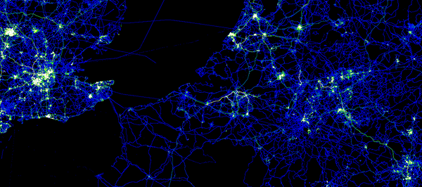
This version of the GPS data file is CC-By-SA and published by OpenStreetMap and Contributors. The image in this article is a visualization of some of this point data in Europe. The image is licensed similarly and was created by Dave Stubbs.