Category Archives: Uncategorized

Project of the Week: 02 May 2010 – “What’s in a Name?”

“What’s in a name? That which we call a rose
By any other name would smell as sweet.” –Juliet

What is in the name tagss of OpenStreetMap? In most cases, the name
tag holds the default name of an object. Very often this is the text
from the sign attached to the object. We even have name:?? to
describe names in different languages so that we can create maps for
many users in many places.

The big name fixup

But there are names that are in error in OpenStreetMap. And some of
them are fairly easy to clear up, if you know that they are a problem.
Consider some of the longest name fields in OSM. From the examples
below we can see that some of the longest names in OSM include
needless duplication.

Learn how you can find errant long names and how you can fix them from
the OpenStreetMap wiki.
http://wiki.openstreetmap.org/wiki/Project_of_the_week/2010/May_02

What would it take to map an entire country?

“What would it take to map an entire country?”

With the growing visibility of Map Kibera, that question is coming
more frequently, especially in Africa, where both OpenStreetMap and
traditional mapping are widely absent. This is a massive question,
which is going to depend very much on circumstances of that country,
and on who is asking that question; and in the end may be better
answered by a different question. In response to a couple queries,
from Liberia and Malawi, I decided to write up a few blog posts to
start off those conversations, and serve as reference for any of the
other 200+ countries on this planet. To start, going look at a few
examples to serve as models for answering the question.

Up front, the question assumes one very important thing;

Read the rest of Mikel’s observations on the Map Kibera blog.
http://www.mapkibera.org/blog/

Nice quote from Doctorow’s Makers

Hollywood, Florida’s biggest junkyard was situated in the rubble of  ahalf-built ghost mall off Taft Street. Suzanne’s Miami-airport rental car came with a GPS, but the little box hadn’t ever heard of the mall; it was off the map. So she took a moment in the sweltering parking lot of her coffin hotel to call her interview subject again and get better coordinates.

“Yeah it’s ’cause they never finished building the mall, so the address hasn’t been included in the USGS maps. The open GPSs all have these better maps made by geohackers, but the rental car companies have got a real hard-on for official map data. Morons. Hang on, lemme get my GPS out and I’ll get you some decent lat-long.”

Image of the Week:

Media_httpimgurcomc6t_wapey

The OSM test of “free”-ness — can you bake it on a cake?
http://blog.okfn.org/2010/03/15/the-cake-test-of-freedom/
Shown here: map from the Marikina Mapping Party
http://wiki.openstreetmap.org/wiki/Marikina_Mapping_Party

The Marikina Mapping Party was the fourth Mapping Party in the
Philippines. It occurred on a Saturday, March 20, 2010. They also had
cake.

About Image of the Week
These are Featured images, which have been identified as the best
examples of OpenStreetMap mapping, or as useful illustrations of the
OpenStreetMap project.

If you know another image of similar quality, you can nominate it on
Featured image proposals.
http://wiki.openstreetmap.org/wiki/Featured_image_proposals

Project of the Week – 25 April 2010: Table for 1/4 million

Tell us about a great restaurant. Put a restaurant that you know
about on the map. Even better if this is a small, family-run
business, but a big business or chain restaurant is okay too. Perhaps
a cafe, or a fast food join. Maybe a drive in or a greasy spoon.
Fine dining or great value. Famous five-star or unknown treasure.
Put a place that gave you a great meal on the map.

The restaurant doesn’t have to have seating for all of the 1/4 million
OpenStreetMap contributors at one time.

Find more details about this Project of the Week.
http://wiki.openstreetmap.org/wiki/Project_of_the_week/2010/Apr_18

This is your Project of the Week. Make suggestions.
http://wiki.openstreetmap.org/wiki/Project_of_the_week/Proposals

New to OpenStreetMap? Join the mailing list for new OSM mappers.
http://lists.openstreetmap.org/listinfo/newbies

Palace Grill photo by http://www.flickr.com/photos/swanksalot/ is licensed
ccbysa http://creativecommons.org/licenses/by-sa/2.0/deed.en_CA on Flickr

OpenStreetMap data is on your train

From Simon Clayson’s Flickr stream, we learn that OSM iz in yer
tranez. I’m sure that’s what the cool kids would say. More from
Simon:

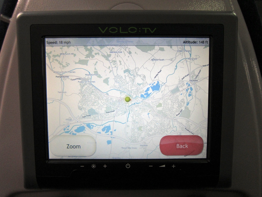
Great Western Trains have some seats with airline style LCD
“entertainment” screens. More interesting than paying £1.50 to watch
an episode of Friends is the “You are exactly here” screen which is
free. And it uses Open Street Map! Good work Volo TV.

Simon also tells us that the maps are attributed. He says, There’s
a big notice as you arrive on the page that thanks the “Contributors
of OpenStreetMap”

Photo of OSM map on VOLO:TV by Simon Clayson.
http://www.flickr.com/photos/claypole/
The photo is licensed cc-nc-nd
http://creativecommons.org/licenses/by-nc-nd/2.0/deed.en
Hat tip to mikel for pointing this out.

Jon ‘maddog’ Hall Picks OSM for one of Today’s Six Best OSS Projects

Hot New Projects – In the Eye of the Beholder

From the fine article:

You would think that writing a blog entry on “Hot New OSS Projects”
would not be that difficult. All you should have to do is go to
SourceForge or Freshmeat and see what projects are being downloaded,
or at least accessed, and write about them. Or, hangout on Slashdot or
LinuxDevices.com and see what cool things are being shown and talked
about. These days you can even read the mainstream media about Linux
products and projects. And of course there is the Linux.com site with
its news feeds, discussion groups and projects.

All of these would have been “too easy” for maddog, so of course he
had to do the unthinkable and ask his eclectic group of Linux User
Group (LUG) members what they thought were “Hot, New OSS Projects.”

The first message that came back from the “call for thoughts” was:

“What do you mean by OSS project?” followed by “What do you mean by
new?” and (of course) “What do you mean by Hot’?”

Read the full article on linux.com to see where OpenStreetMap finished
on the list.

http://www.linux.com/news/software/applications/301412-jon-maddog-halls-picks…

OpenStreetMap U.S. Inc

Kate writes on talk-us:

Hey All,

Just wanted to let you know OpenStreetMap U.S. Inc exists now. This
is so we can eventually become a chapter of OpenStreetMap. We’ll be
moving forward with getting an EIN (tax number) from the IRS, working
out the Chapter agreement, etc shortly.

Then of course having official membership soonish.

🙂