Author Archives: HarryWood

About HarryWood

Posting mostly in a Communication Working Group capacity (and often with text written collaboratively among CWG and others) About me on the OSM wiki

OpenStreetMappy Christmas

OpenStreetMappy Christmas to all the map contributors and users!

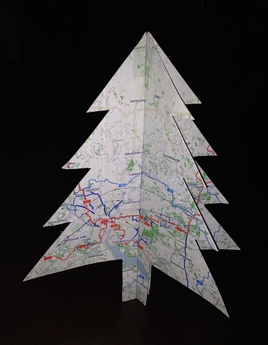
Russian user te_mark recently noticed that the OpenStreetMap node with id number 1, was quite nearby, so he went to go take a look at it, and posted a photo of what he found:

It’s a christmas tree! (or at least a fairly christmassy-looking tree. A tree with needles, as the leaf_type=needleleaved tag accurately records!)

Take a look at node number 1 for yourself.  Now we have to point out that, although it has id number 1, this is not the first ever node in the OpenStreetMap database. It just ended up with this id number after some database re-arrangements of these low-numbered ids. OpenStreetMap has 3.1 billion nodes in the database, and of course this number is rising all the time as more and more data is contributed. Nodes can represent all kinds of things. Often they’re just mid-points along a way, but yes… nodes can represent trees. We have nearly 6 million of those on OpenStreetMap.

So whichever leaf_type you get in your part of the world, we hope you have an OpenStreetMappy Christmas!

Welcome new board

At the weekend we held our 2015 Annual General Meeting, and foundation members voted to elect four new board members. Congratulations to…

They join Kate Chapman, Frederik Ramm, and Paul Norman on the foundation board. Thanks to all eleven candidates who took part in the election, and thanks to the members for asking questions, debating the issues, and casting your votes.

For more voting details including passing of a special resolution, see the public meeting minutes and transcript.

As well as finalising the election, the Annual General Meeting included presentation of the chairperson’s report from Kate Chapman, and the treasurer’s report from Frederik Ramm.

The election campaigning/discussion included great ideas about future directions of OpenStreetMap and the foundation. Let’s bring some of these ideas to life in the coming year! Don’t forget, one of the key ideas all candidates agreed upon, was encouraging more involvement from the OpenStreetMap community in the work of the fundation e.g. via working groups. So now’s a great time to get involved!

OSMGeoWeek

This week (starting tomorrow) is Geography Awareness Week. This year we’re joining in this celebration of all things geography, by holding mapathons all around the world. We’re calling it “OSMGeoWeek.”

osmgeoweek-paper-globe

OSMGeoWeek globe by Dan Joseph. Print your own with this PDF

Check out osmgeoweek.org, to see the line-up of events. OSMGeoWeek is a collaborative effort of many partners including MapGive (U.S. Department of State), the Peace Corps, USAID, the World Bank’s Global Facility for Disaster Reduction and Recovery, Missing Maps, and of course the Humanitarian OpenStreetMap Team aiming to get up to 100 mapathons organised worldwide. Why not organise an event in your town? Use the contact links on the site if you have an event you’d like to see added to the list. We already have events confirmed in more than 20 countries.

mapmydayAnother event coming up next month is Map My Day (mapmyday.org). This is a wheelchair accessibility mapping event organised by the awesome people behind wheelmap.org. Get ready to join in with that one on December 3rd.

Board elections 2015

It’s soon time for members of the OpenStreetMap Foundation to elect new leadership to the OSMF board. The foundation board is made up of seven people, of whom three will be remaining for an extended term, while four seats are up for election.

Our choice of candidates is not finalised yet. Candidate nominations are open up until Sat 21st Nov. If you are involved in the OpenStreetMap Foundation, and you’d like to step up and help set the future direction of our organisation, why not put yourself forwards for election to the board? Candidate details can be found on the election wiki page.

After that deadline we have one more week and then the voting will open, The following week after that, voting will close, coinciding with the Annual General Meeting. This has been officially announced and scheduled for Saturday, 5th December.

New OpenStreetMap US board + Upcoming foundation elections


OpenStreetMap US ran a board election process recently, and yesterday they announced their newly elected board members. Congratulations to Ian Dees, Alex Barth, Alyssa Wright, Martijn van Exel, and Drishtie Patel! The run up to the election included this recorded video conference featuring the candidates, which seems like a great way to get to know the personalities involved. If you’re based in the U.S. be sure to get involved in this local OpenStreetMap organisation: openstreetamp.us

The OpenStreetMap Foundation (the organisation supporting OpenStreetMap globally) is also kicking off a board election process. The election will take place in December, so now is a good time to join the foundation if you are not already a member. This is a great way to support OpenStreetmap, and the osmf-talk mailing list will bring you updates on how the board elections will work. Read more on the election wiki page where we are also inviting new board candidates to step forwards.

Birthday and hack weekend

Last weekend OpenStreetMap turned 11 years old, and we celebrated the birthday in Passau, Fukushima, Moscow, Chennai, Taipei, Bengaluru, Beijing, Zurich and London!

The 11th birthday cake arriving for the party in Bengaluru

The 11th birthday cake arriving for the party in Bengaluru

In London this coincided with the OpenStreetMap hack weekend event. Developers came together to do technical work on OpenStreetMap, this time with a “mobile” theme. You can read more about the event on the wiki. Thanks to Rob Nickerson who listed out the various things we worked on. He visited from Birmingham, and then wrote it up on the OSM birmingham blog. We even had a write up on the Ordnance Survey blog, because the event was hosted at the ordance survey “Geovation Hub“. A fantastic venue! We hope to be back there some time, and we hope to see more collaboration between OpenStreetMap and the UK national mapping agency. Also thanks for the pizzas PIE mapping.

Of course technical developments in and around OpenStreetMap are taking place all the time all over the world. These include external applications such as mobile apps, and improvements to more core components. Just today Paul Norman released osm2pgsql version 0.88.1 for example. Several of our contact channels are dedicated to development work, and the engineering working group are keen to find ways of getting more developers involved.

So if you missed the hack weekend or you missed out on the birthday cake, don’t dispair! There’s lots of ways to get involved in OpenStreetMap.

Target reached – Thank you!

Today we’ve reached our fund-raising target: £56,000 !

thank-you-restaurantosm.org/go/ZUfMByg0Z

The Operations Working Group set out their detailed plans for the server upgrades they’d like to do: A big new database server, new tile servers and an imagery server. Thanks to your generosity, we now have the funds in place to make that a reality.

This has been our largest fund-raising target, but given the scale, reach and impact of OpenStreetMap, £56,000 is a small amount of money. For the thousands of data consumers, and millions of map end-users viewing OpenStreetMap, or the mega-corporations our maps are compared against. Don’t we deserve more? Lots of interesting discussions around this topic, but I will just say for now… Yes we do! And of course you’re very welcome to donate more:  donate.openstreetmap.org

The OpenStreetMap Foundation remains open for donations. If you have ideas on how to get more recognition and big donations for OpenStreetMap, this is always welcome too!

For now though, we want to say a big Thank You again to Mapzen and Mapbox who made big donations to kick things off, to various other organisations who made donations to support us, and to all the individuals (more than 1200 of them!) who generously chose to put their personal money towards the OpenStreetMap cause.

£36k raised, £20k to go

We’re seeing a steady flow of donations large and small coming in. At £36,052 we’re well over half way to our fund-raising goal. A big thanks to Mapzen and Mapbox who kicked off in style, each with a donation of US$20,000!

MapboxMapzen

With awareness spreading quickly now, we’ve doubled the number of people donating just in the past 24 hours! Each supporter can choose to be named on the donations page, and leave a message to us, so if you didn’t do so already, make a donation now!

Find out all about the server funding drive and donate on:

donate.openstreetmap.org

Don’t forget you can also support OpenStreetMap by becoming a member: as an individual or as a corporation.

OpenStreetMap Local Chapters – Welcome Iceland

The OpenStreetMap community has a wide array of different local groups forming in different corners of the globe. It’s time to formalise the idea of “local chapters”. We now have a definition and a process, and we have our first official OpenStreetMap Foundation Local Chapter!

openstreetmap-iceland-website

OpenStreetMap á Íslandi” is a subgroup of Hliðskjálf, an Icelandic society for open and free geographic information data. Well done to Jóhannes from Hliðskjálf who went through the process of getting this organisation set up as an OpenStreetMap Chapter.

Of course we have always had local OpenStreetMap groups forming all around the world, small groups of collaborating mappers, but also groups on a bigger country scale. These organisations help to present OpenStreetMap in a particular language, and engage a community with consideration for local culture and customs.

The idea of local chapters has long been discussed, as a name for these groups. We’re borrowing this idea from the Wikimedia foundation. And now we are formally introducing local chapters as a way of establishing a relationship between regional OpenStreetMap organisations and the OpenStreetMap Foundation. This is a hugely important step in the development of the OSMF.

The actual definitions, requirements and processes have been laid out. Read these, and more information, on the Local Chapters page.

Happy Christmas from OpenStreetMap

OpenStreetMappy Christmas Card

Happy Christmas from OpenStreetMap to all of our contributors.

This sentence doesn’t actually make sense when I think about it. It’s a familiar kind of sentence you might see on a company website, but OpenStreetMap is a project. A collaboration. A map, a database and a community. It’s not a company. I sometimes describe it as a “nebulous internet collective”. OpenStreetMap is all of our contributors. So when we say a Happy Christmas from OpenStreetMap, we are all wishing ourselves a Happy Christmas. Maybe it does make sense. I think I can speak for all OpenStreetMappers in wishing each other a Happy Christmas.

We’re all working together on this project to create an open licensed map of the world, and whether you’ve met other mappers or not, whether you’ve engaged in community discussions or not, you have added your contributions and slotted your piece into the jigsaw of this mighty collaborative endeavour. Please turn to the OpenStreetMapper on your left and wish them Happy Christmas! (Or seasons greetings, happy holidays, happy winter festival… whatever fits)

And a Happy Christmas to all those who are using OpenStreetMap. All those who have seen maps embedded on a website, downloaded maps to their mobile apps, or printed maps out on paper. We hope you enjoyed OpenStreetMap, and of course there’s an easy way to give us a Christmas present in return: Get involved!