Author Archives: HarryWood

About HarryWood

Posting mostly in a Communication Working Group capacity (and often with text written collaboratively among CWG and others) About me on the OSM wiki

10 Years of ODbL

Ten years ago today we changed the license of OpenStreetMap’s data. For those who remember it, you’ll know it took a lot longer than a day. It was slow and painful process, but we published our first ODbL-licensed “planet dump” on 14th September 2012!

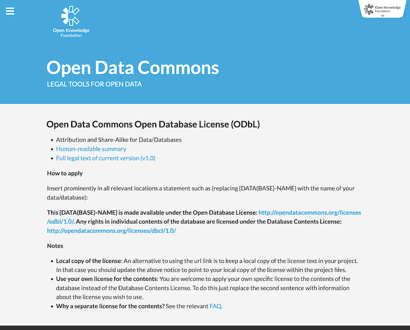
In the run up to that moment we spent several years working with the Open Data Commons organisation to create the Open Database License, reaching broad community agreement upon it, then seeking formal acceptance from every data contributor, and carefully redacting data where this acceptance was not received. All of these steps required vast effort from volunteers, culminating in the switch-over moment. In fact even after the big announcement (on this blog) it took a couple more days before we were able to publish the data ten years ago today!

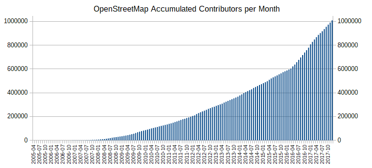
In those ten years we’ve seen spectacular growth, not just in data and community, but also in users and uses of our data under ODbL. You can read more about the license change reasoning and process here, but if you’re interested in using OpenStreetMap data … download it. It’s free and open licensed!

New Tile Render Server in the USA

We have a new Tile Render server in the United States! The hardware has been kindly provided by OpenStreetMap US and hosted by the Oregon State University Open Source Lab. Big thanks to them, and to Ian Dees who coordinated this response to the Operation Working Group’s request.

Our distributed tile serving infrastructure brings the “standard” map tiles to your browser wherever you are in the world in a reasonably fast fashion, resulting in a pleasant map viewing experience on the OpenStreetMap.org front page, and with new map edits reflected a few minutes after they are made. It should always be noted that this is far from the only way of using our maps, and we encourage developers to take our data, render it, and otherwise make it available to users in a new ways. However, we do like the front page map to work well. We have a set of “rendering” servers doing the hard work of creating and refreshing raster map tiles, and a larger set of caching servers. With the introduction of a new rendering server in the United States (the first outside of Europe) tiles will load faster. The server itself is fast, and for users in the United States we expect to remove about 100 milliseconds of latency for people viewing the map.

Network latency for requests to the new tile server from various locations in the USA

Details of this new server (which we’ve named “Pyrene”) can be found on the hardware.openstreetmap.org site.

We’re still building our tile serving infrastructure, with a lot of help from people and organisations donating resources. If you are in a position to help with this sort of thing, a caching server – or better yet a rendering server – in India would make a huge performance improvement for people there. Learn more about the kind of servers we need at our wiki page and contact the Operations Working Group.

Happy Birthday OpenStreetMap

Cake in Fukushima, Japan © CC-BY-SA 3.0  Ikiya and family

OpenStreetMap is 14 today! We’ve been partying in various locations around the world: Hyderbad, New Delhi, Moscow, Kigoma, Rapperswil, London, Washington DC, Denver, and Seattle.

Celebrations in London

Celebrations in Dhaka, Bangladesh, after a mapathon

If you missed the birthday party, don’t worry. Our community is lively with events happening all the time. You can see some of them listed on the current events list here, or find out more generally what’s happening in your country/city on the wiki.

Cake in Washington DC

The true “Birthday” of OpenStreetMap is lost in the sands of time. Observance of the anniversary of the creation of OpenStreetMap is held on or about the anniversary of the registration of the OpenStreetMap.org domain name (9th August). This year 12th August seemed like a suitable Sunday!

With over a million people making OpenStreetMap edits, and around 5000 people making edits on any particular day, it’s hard to imagine a time when all of this hadn’t even got started yet, But that time was 14 years ago, in the summer of 2004. We’ve come a long way since then. Wherever you are in the world, join us in saying “Happy Birthday OpenStreetMap!”

SotM Milan – Thanks for coming!

With over 420 attendees from 54 different countries, the OpenStreetMap community came together in Milan, Italy, for another fantastic annual State Of The Map conference at the weekend. Thank you to everyone who made it to Milan.

…and of course a big thank you to the organising team for putting so much work into making the conference the huge success it was. The SOTM organizing committee is composed of the international organisers: Benoit Fournier, Christine Karch, Gregory Marler, Mikel Maron, Rob Nickerson, & Michael Reichert and the local team in Italy: Alessandro Palmas, Alessandro Saretta, Francesca Ussani, Marco Minghini, Maria Antonia Brovelli, Maurizio Napolitano & Michael Montani, and a wider team of volunteers who joined in to help the event run smoothly. Thank you all!

Some of the local SotM volunteers and organisers on stage at the closing session

Videos are already available in unedited form, for the two main conference rooms across the three days:

Finally thanks to the conference sponsors:

bing, facebook, mapbox, Telenav, immobiliare.it
Garmin, Kaart, mapillary, maps.me, OSMAnd

There’s lots to talk about from the conference, including several other announcements which will be coming soon here!

Server moves: Goodbye Imperial. Hello Equinix Amsterdam

Servers de-racked and ready to move

Some of our servers are moving to a new home. Quite a few of our important servers have been housed at Imperial College in London for the past few years, but it’s time to move on from there as they look to reclaim some space for offices. We’d like to thank Imperial for our time together!

We continue to be thankful to University College London, and Bytemark who are still generously providing hosting for some other keys servers, not to mention our many Tile Cache hosts around the world. If you’re interested in server details you can see the full list on our hardware page.

That list is set to change very soon, as Imperial machines are powered down and moved. The move is being carried out this week by volunteers from the OWG/OSMF.

Where are we moving these servers to? We sought proposals for a new home (thanks to all those who replied), and Equinix Amsterdam has been selected as our new data centre provider. This brings a little more diversity of locations for our servers (many of the others being in the UK), but it’s still not a million miles away, in case our operations team need to visit. Equinix Amsterdam provide excellent “smart hands”, removing the need for physical visits on a regular basis. That being said, the Operations Working Group are seeking someone to help in Amsterdam who can visit the data centre if we need. To quote the OWG folks this volunteer would “need to be trusted, competent and did I say trusted”!

As ever, we owe a big thanks to OWG volunteers for all the hard work going into managing these server moves.

1 million map contributors!

We passed a milestone recently which deserves some celebration: OpenStreetMap has now reached 1 million map contributors. Over the lifetime of our project, 1,000,000 different users have created a user account and made edits to the map! 1 million is a big number, and the growth of our community continues apace.

“At its core, OpenStreetMap is all about humans sharing knowledge about the places they visit, live and work in. Our fantastic project is only possible thanks to over a million individuals who generously volunteer their time to help others find their way in the world.”
Peter Barth – OSMF board

If you haven’t tried contributing to OpenStreetMap yet, it’s not too late to join a million others! sign up today and map your neighbourhood!

You may remember we celebrated 1 million users way back in 2013, but that was the count of signed up users — an impressive number, but not everyone who signed up has yet contributed to the map (Why have users signed up but not contributed? The reasons for this have been described in various ways over the years but similar participation patterns are seen in many online communities)

Simon Poole has been crunching the changeset logs and watching the count of map contributors tick past 1 million:


Read Simon’s diary entry for more analysis including a look at recent editor software usage trends. Of course we are tracking many other stats on our ‘stats’ page too.

So let’s celebrate! One million and still growing!

Welcome OpenStreetMap France

OpenStreetMap FranceWe’d like to welcome OpenStreetMap France (openstreetmap.fr) as an official OpenStreetMap Foundation Local Chapter.

OpenStreetMap France was established back in 2011 as an independent non-profit voluntary association, and over the years they have achieved great things, including organising hosting (with some funding and donated resources) of some important services, not just for the French users, but for the global OpenStreetMap ecosystem:

Of course they also host the openstreetmap.fr website, for which a new version is under development, and a French-speaking forum, and they support projects like OpenLevelUp, Caribe Wave/HAND, and Jungle Bus.

But beyond hosting things, they’re also a general advocacy organisation for OpenStreetMap in France, seeking to liaise with other associations, citizens, local governments, small and big companies, national mapping agency, postal services and anyone seeking an entry point within the OSM project and community.

A few months ago they were formally recognised as a OpenStreetMap Foundation Local Chapter.

Benoit Fournier is signing the Local Chapter agreement

Benoît Fournier of the OSM France and Ilya Zverev of the OSMF Board are signing the Local Chapters Agreement at FOSS4G Europe 2017 in Paris, photo by Jody Garnett with license CC-BY,

Additionally an OSMF Advisory Board seat was accepted by Christian Quest from OpenStreetMap France.

This makes five local chapters formally established by the foundation, and there are more to come!

If you’d like to know more about OpenStreetMap France, contact them directly or discuss with the community on the ‘talk-fr’ mailing list. Or if you’d like to meet face-to-face, check out the SotM-France local conference. Now in its 6th year, in 2018 it will be taking place in Bordeaux June 1st-3rd

Welcome OpenStreetMap UK

Catching up on news from SoTM in Japan, we have a couple of new local chapter announcements. Firstly, welcome OpenStreetMap United Kingdom!

Signing of the OSMUK Local Chapter Agreement at State Of The Map 2017 in Japan.
Left to right: Frederik Ramm, Ilya Zverev, Jon Harley, Rob Nickerson, Gregory Marler, Paul Norman, Martijn van Exel

This new local chapter organisation, like others, is a formal registered organisation (in this case a UK “Community Interest Company”) setting out with the mission to further the interests of OpenStreetMap, working with the OSMF, but focussed on this particular territory.

Their documented aims are to…

  • Increase the quality and quantity of data about the UK in OpenStreetMap.
  • Improve and increase the size, skills, toolsets and cohesion of the OpenStreetMap community in the United Kingdom.
  • Promote and facilitate the use of OpenStreetMap data by individuals and organisations in the United Kingdom.
  • Promote and facilitate the release by organisations in the United Kingdom of data that is suitable for use in OpenStreetMap.

The United Kingdom was the birthplace of the OpenStreetMap project, and has been home to a registered organisation for a long time now; the OpenStreetMap Foundation itself! But the OSMF is global in scope, and is these days very globally distributed in terms of membership, contributors, and resources. The UK community has also, for long time, had a dedicated mailing list, irc channel, and forum, but until recently, no formal organisation to support it. OSMUK is getting set-up with a web page (osmuk.org) and will be tackling the UK’s specific flavour of community building and government/industry engagement challenges. See also
Why our Local Chapter status matters
on the OSMUK blog.

If you’re in the UK OpenStreetMap community you should join OSM UK! and also join in with discussions happening on their new loomio group.

OSMUK was not the only local chapter to be formally signed on at the conference. Stay tuned for another announcement! If you’d like to know more about setting up local chapters, check out the Local Chapters page.

OpenStreetMap Awards

DINACon digital sustainability


The OpenStreetMap community recently received an award at the DINACon conference on digital sustainability.

OpenStreetMap is showing itself to be sustainable in various ways. Our database is available to download in its entirety, which helps to ensure the hard work of our contributors will always live on regardless, but our core servers keep humming thanks to many generous donations to OSMF over the years, as well as funding from our corporate membership programme. Most important of all, our community continues to thrive, attracting new members, while retaining wonderfully dedicated long-term contributors (to whom this award was dedicated). Thank you to everyone who helps make OpenStreetMap sustainable.

Thanks also to Simon Poole, Stefan Keller, and Michael Spreng who accepted the award, as well as running an OpenStreetMap session at this conference.

While we’re on the topic of awards…

OpenStreetMap Awards 2017

During our own conference, the international State Of the Map, in Japan back in August, we held the OpenStreetMap Awards ceremony. If you missed it, these are the results:

  • The Core Systems Award went to Kevin Bullock – For making available two new satellite imagery layers directly from DigitalGlobe, which drastically increased coverage in OSM editors
  • The Innovation Award went to Tobias Zwick – For the StreetComplete android application, which drives thousands of attribute edits to OSM
  • The Influential Writing Award went to Ramani Huria – Great blog posts about community, mapping, techniques for OpenStreetMap in Tanzania and Africa.
  • The Greatness in Mapping Award went to Jochen Topf – For the global polygon fixing effort, which updated all the old-style multipolygons and continues to fix thousands of errors every day
  • The Expanding the Community Award went to Pete Masters – For 4 years as Missing Maps project coordinator, introducing countless contributors to OSM, supporting communities in Bangladesh, DRC, CAR and many other countries. Remarkable outreach for humanitarian mapping & OSM in general.
  • The Improving Latin America Award went to GeoChicas – Working against sexism and making projects to integrate OSM’s users
  • The Improving Africa Award went to the State of the Map Africa Organising Team – For putting huge efforts into making SOTM happen in Africa for the very first time
  • The Improving Asia Award went to Humanitarian OpenStreetMap Team Indonesia – For training disabled people and their carers to map the areas they live. A great example of how inclusivity and diversity can by both fostered and supported by OpenStreetMap
  • The Ulf Möller Memorial Award went to Martin Raifer – For the Overpass Turbo web based data mining tool.

The OSM awards website has a list of all nominees, and details of why they were nominated (also on this blog). Well worth a read. It’s a catalogue of spectacular individual contributions made to OpenStreetMap throughout the 2016/2017, and all of these nominees deserve our congratulations.


Thanks to the SoTM 2017 organisers

The international OpenStreetMap conference, State of the Map 2017, took place last weekend in Aizu Wakamatsu, Japan. Three fantastic days of talks and workshops on all things OpenStreetMap. Thanks to all those who attended!

Here’s the group photo (for those who got up early to be in it). There are many more photos to be found here on the facebook group (cc-by-sa-4.0)

Huge thanks also to the SOTM organising team. This team is made up of a group of long-term conference organising stars, and also the local team who this time were our wonderful hosts in Japan.

The folks handling the video recording have done a very speedy job of publishing all the recordings from the the two main rooms:

Session videos


As mentioned, there’s also a big collection of photos on a facebook group. Also check out the #sotm tweets, and a SOTM 2017 wiki page where we can link these things as well as blog write-ups etc.  We’ve shared so many ideas a this conference, let’s try to keep track of them all! Also stay tuned for more blog posts following-up on some conference themes.