More and more people and organisations are considering switching to the OpenStreetMap platform for displaying and processing geographic data. There are various reasons why one might like to switch:
Why switch
OpenStreetMap provides open geodata freely to all
Our licence says that you can always copy and modify our data for free.
Your obligations are:
- Attribution. You must credit OpenStreetMap with the same prominence that would be expected if you were using a commercial provider.
- Share-Alike. When you use any adapted version of OSM’s map data, or produced works derived from it, you must also offer that adapted data under the ODbL.
See OSM’s copyright guidelines.
You can make the maps that suit you
With OpenStreetMap, you’re in control. Turning the data into rendered maps can be done any way you like. Want to emphasise cycle routes and play down motorways? No problem (Most other maps don’t even have cycle routes). Want to label subway stops but ignore bus stops? Easy.
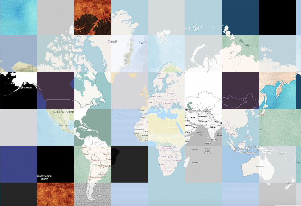
Rich, accurate, up-to-date map data
- Rich: OpenStreetMap might have “street” in the name, but we do much more. Natural features, bus routes, footpaths and cycleways, administrative boundaries, shops, rivers and canals, benches… you name it. See some of our map features (there are more than those listed).
- Up-to-date: Data on www.openstreetmap.org is constantly updated, and you can get those updates every day, every hour or even every minute if you want.
All this is contributed by our volunteers (over 1,000,000 contributors so far, and growing every day) – the people who really know about their area.
It’s easier than you think
There’s no limit to what you can do with OpenStreetMap. Yet it needn’t take long to get started. You can switch to OSM in under an hour using tools like the easy Leaflet API. Head over to switch2osm.org to find out what possibilities there are.
I want to use OpenStreetMap data
Sure. Read on at using OpenStreetMap.
Can I deploy my own slippy map?
Yes. A slippy map shows map tiles on your web page by using JavaScript code. Please read deploying your own slippy map. Apart from raster tiles there is also the possibility to display a map with vector tiles.
Any advice on using OSM tiles?
Apart from very limited testing purposes, you should not use the tiles supplied by OpenStreetMap.org itself (Tile usage policy). OpenStreetMap is a volunteer-run non-profit body and cannot supply tiles for large-scale commercial use. Rather, you should generate your own tiles or use a third party provider that makes tiles from OSM data.
Docker image
People that would like to self-host may also consider using a docker image (example).
I would like to use the OSM editing API or Nominatim
Please read our
- API usage policy (Also note some upcoming API changes related to user data for GDPR compliance).
- Nominatim (search) usage policy.
What is considered heavy usage?
If your usage is in any way mission critical for you, you should consider hosting yourself (or paying someone to host for you).
I would like to ask some questions
Sure, go ahead!
- There is a Q&A platform where your questions might have been already asked and answered. Feel free to ask new ones.
- We have a forum where there is a dedicated Development subforum.
- There is a developer mailing list.
- If you need to reach our Operations Working Group, please note that they are all volunteers and very busy.
I have switched to OSM!
Welcome to our community!
- We would love if you spread the word about your switch (#switch2osm) on your favourite social media.
- You can add new OSM-based map services to this list (not for personal websites but map services).
I would like to help!
Great! There are various ways you can help the project.
- Consider joining the OpenStreetMap Foundation, which supports the project. The OSM Foundation is an international not-for-profit organization supporting, but not controlling, the OpenStreetMap Project.
- How about joining one of the OSM Foundation Working Groups? Working Group members are all volunteers, so your help matters. Considering joining the Operations Working Group? See the membership and sysadmin policies.
- Develop the OSM platform! Help develop improvements to OSM or new ‘provider’ services which make switching to OSM even easier. Please read wiki.openstreetmap.org/wiki/Develop.
- Create a free account on www.openstreetmap.org to help make the best map ever!
Sources: switch2osm.org wiki.openstreetmap.org osmuk.org/pinned/reduce-costs-switch-openstreetmap

")