Monthly Archives: June 2019

Why your community should host State of the Map

Post by Gregory Marler on LivingWithDragons. Re-posted with permission.

The OpenStreetMap event of the year is “State of the Map” (SotM), an international conference run by the OpenStreetMap Foundation and I love being part of the organising committee that brings so many people to one place. We’re volunteers and it takes a lot of work and a lot of local knowledge throughout the year to organise a 400+ conference, so we ask for communities to bid to host it in their city/area. There’s support in overseeing what needs to be done, budgeting, and links with previous sponsors, but it relies on a full local team to join in the help. This led me to ask, why should your community host State of the Map?

The photographer takes a group photo of delegates and team at SotM 2018 (Italy)

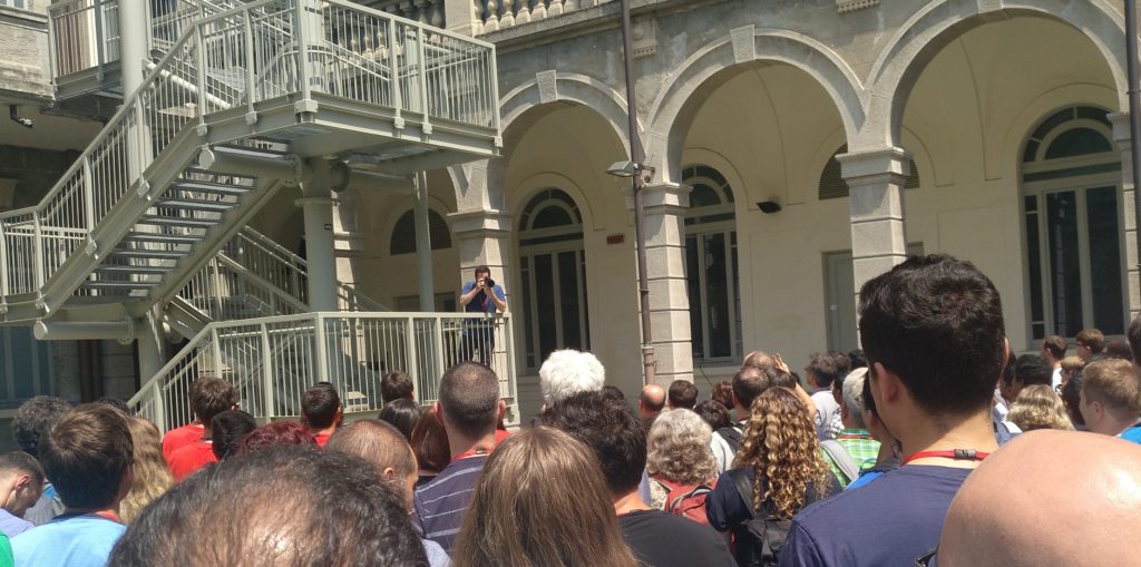
It will use the skills of your community. The organisation work requires researching suppliers of booklet printing, catering, etc. It needs people to communicate with the venue and with our sponsors, even speakers and scholarship applications. There’s usually help needed with graphics and there’s space for people to suggest new ideas for the conference. During the event we need welcoming people, and people to keep the schedule running on time. There’s so many different things to do and they vary in how visible from them. I firmly believe the best way to appreciate individuals is to know they’ve dealt with an essential task or to encourage them to take on a task you think they’ll be good at.

Along with the conference, of course comes lots of knowledgeable people. In the talks and in the coffee break discussions you get to hear updates about OpenStreetMap, learn new things or get more detail from the experts and different communities. This is both for your local SotM team, as it’s encouraged to listen to the talks if you’re helping out, and it’s for your wider community of OSMers and newbies in the city/country/region. This can be a great chance for locals to attend SotM when they might not usually due to travel distance and barriers such as costs or visas.

Stickers at a SotM Scotland event in 2012

Don’t think about one weekend, as often the conference is a catalyst to have more local events. In the build up to SotM you’ll want to meet more often and you’ll get to know people who live near by. Hosting SotM has also led to more events following it as people want to continue the in-person sharing of knowledge and community. You might host extra events in collaboration with other organisations, in the past countries have even ended up having scenarios like “The month of maps”. I would encourage you to have had some community meetups before bidding for SotM, it gives you practice setting dates, communication, and venues.

Remember that OpenStreetMap is not about a conference. However, the conference helps us build new understanding. This can lead to new contributors joining OpenStreetMap (maybe getting more involved) and new uses of OpenStreetMap by being inspired and encouraged what others can do. You might want to invite local government or companies that are on the fence with deciding to use or release open data.

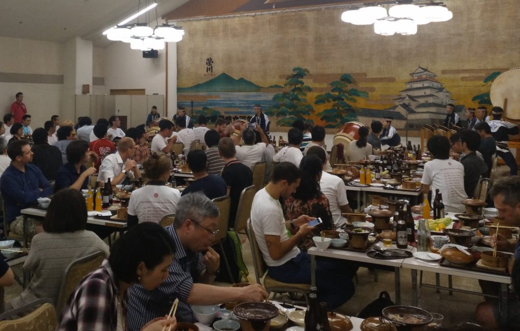
My last reason is that, it’s fun. We’re all a nice bunch of people really. There’s usually an organised social evening at SotM (we’ve had private tram tours, picnics in the park, a performance by Japanese drummers, all sorts). On the other nights the visiting mappers will look to your community team for advice on where to eat/drink and what are really the best nearby tourist sights. If you love your town, then you should love sharing the best bits and the secrets with the new friends you make.

What to do now? First of all, read the Call for Venues page, because that contains a lot better detail on what is needed to be ready and what is needed in your bid. I would suggest getting together a community that is interested in hosting, even if they have different levels of interest and different amounts of availability. Find a date to give about 2 weeks notice, find a place to meet like a coffee shop or a friendly office, and use various social media to invite local mappers to come and chat about State of the Map in your town. You might start writing the bid there (copy the example bid format), you might assign people to go away and research the different sections required.

Dinner and a drum performance at State of the Map 2017 (Japan)

You are very welcome to contact the SotM team early on, this might be once you’ve suggested it to your community it might be before that initial meeting I suggested. We want to help you out, and to help you with your bid. This could be linking you up with others nearby that have got in touch with us, or answering questions you have.

After the bids come in we get the challenge of choosing which bid will host SotM next year. It’s a difficult decision, and we’ve come to learn what will make the conference run smoothly. Don’t be disheartened if your bid is not selected. All that research and team building can be usefully adapted to running a smaller conference for your country or region (there’s a whole list of them). These won’t be an OSMF-run conference but the global team is still keen to assist in small ways. Often local/regional conferences contact us with their proposed dates before they announce, and find it helpful to know if they might clash with others (potentially causing less people to attend). Running a country-level conference can also show how well you can run an event, it could set you up well to bid for SotM in future years. I’d love to see some of the previous ones run on an international level, and it’s great to see more of these pop up.

The Call for Venues deadline is 30th August 2019.

Gregory Marler

Follow State of the Map @sotm!

The State of the Map conference is the annual, international conference of OpenStreetMap, organised by the OpenStreetMap Foundation. The OpenStreetMap Foundation is a not-for-profit organisation, formed in the UK to support the OpenStreetMap Project. It is dedicated to encouraging the growth, development and distribution of free geospatial data for anyone to use and share. The OpenStreetMap Foundation owns and maintains the infrastructure of the OpenStreetMap project. The State of the Map Organising Committee is one of our volunteer Working Groups.

Can you help the Operations Working Group?

Image by OSM Communication Working Group, CC-BY-SA 3.0
OSM logo by Ken Vermette, CC-BY-SA 3.0 & trademarks apply.

The OSM Operations Working Group is a volunteer group, responsible for running of the servers owned by the OpenStreetMap Foundation. 
We are always keen to find new members and we are particularly looking for people who:

  • can analyse our server infrastructure
  • make plans
  • forecast future hardware needs
  • draw up budgets

This does involve a certain level of technical expertise but it’s not writing code, for example, and OWG membership doesn’t grant access to any of the servers – that’s for our Sysadmins. If you would like to join us, have a read of our membership policy, and please get in touch!

Some additional information:

  • OWG’s main communication channels are Github and email. We rarely have meetings.
  • Estimate of hours per week: 1-3

Email us at operations@osmfoundation.org
We are also on Twitter @OSM_Tech

If you have the technical expertise and experience to be a sysadmin, read our sysadmin membership policy and get in touch.

OSM Operations Working Group

Do you want to translate this and other blogposts in your language..? Please send an email to communication@osmfoundation.org with subject: Helping with translations in [your language]

The OpenStreetMap Foundation is a not-for-profit organisation, formed in the UK to support the OpenStreetMap Project. It is dedicated to encouraging the growth, development and distribution of free geospatial data for anyone to use and share. The OpenStreetMap Foundation owns and maintains the infrastructure of the OpenStreetMap project, is financially supported by membership fees and donations, and organises the annual, international State of the Map conference. It has no full-time employees and it is supporting the OpenStreetMap project through the work of our volunteer Working Groups. Please consider becoming a member of the OSM Foundation.

OpenStreetMap was founded in 2004 and is a international project to create a free map of the world. To do so, we, thousands of volunteers, collect data about roads, railways, rivers, forests, buildings and a lot more worldwide. Our map data can be downloaded for free by everyone and used for any purpose – including commercial usage. It is possible to produce your own maps which highlight certain features, to calculate routes etc. OpenStreetMap is increasingly used when one needs maps which can be very quickly, or easily, updated.

The June solstice is upon us

Spherical sundial by Simon Moroder. Photo by Giovanni Novara, CC BY-NC-SA 2.0

The June solstice is upon us, which means the seasons are changing — and with that, lots of opportunities to map, no matter which hemisphere you’re in!

If you’re in the northern hemisphere, why not take a look at your local outdoor fun: maybe it’s swimming pools, beaches, hiking and biking trails, and the like. The parks and playgrounds might be busy, as well as sports pitches, places to camp, national parks, wildlife parks and more. Midsummer is also a holiday in many countries, why not map the local traditions like permanent maypoles? Or mapping your local ice cream parlours might be fun.

And if you’re in the southern hemisphere, it’s winter! It may be a bit colder, and good weather for winter sports like skiing, or maybe just staying indoors at your local pub, restaurant, indoor pool and so on. Are your local favorites on the map already? There are also winter festivals all over the hemisphere, have you mapped them? And in warmer climates, it may be nice weather for exploring outside, going surfing, taking road trips and more.

Speaking of the solstice, are the observatories and other astronomical facilities in your area mapped? Is the sundial of the cover photograph mapped?

You can also try recording GPS tracks or taking GPS-tagged photos of your outings to help yourself and others add more data to the map. Or you can even look for things named summer and help complete the map there! For example, the hamlet of Summer, Algeria, the Summer Palace in Beijing, the Summer Place pub in San Francisco and the Summer Hill Creek in Australia. Or maybe there are locations named Winter near you.

Do you have any other ideas for seasonal mapping? Let everyone know in the comments.

Calling for nominees for the OpenStreetMap Awards 2019

Photo by @KTMLivingLabs

We are announcing the call for nominees for the OpenStreetMap Awards 2019, which will be presented this September at the State of the Map 2019 conference in Heidelberg!

These are community awards, as nominees and winners are chosen by the community. The Awards strive to be a worldwide event for all OpenStreetMap members, including developers, mappers, community leaders, blog writers and everyone else. We need your help to find the best of OpenStreetMap globally.

For the fourth awards, we have made some changes. Gone are the three regional categories. Sorry. We have strong enough OSM representation in these countries to be listed together with other candidates. Also, there is a new category: Team Achievement Award. Companies, teams and groups should go there, to not compete with people in other categories. We had quite a lot of issues because of that mixing previously: how do you compare a mapper and an entire local chapter?

We’re mostly looking for new innovations, so only projects/works that were announced after June 1st 2018 are eligible. The Ulf Möller Award is an exception to this. Everyone is eligible regardless of the time when they were active in the project. You personally and your friends are eligible, do add yourself! Winners of past awards and selection committee members (in their categories) cannot be nominated.

The call for nominees will close in a month — on 15th of July. Whenever you see an interesting entry on OSM diaries or in WeeklyOSM, take a moment to submit the name for the award. The more nominees we have, the more interesting the final voting will be. Please keep in mind that we have the OpenStreetMap Awards and nominate people now!

Surveying OpenStreetMap

CC-BY-SA 4.0 OSM CWG

Ahead of the Board Face to Face in Brussels we asked people across the project to share the most important topics facing OpenStreetMap. Thank you to every one of you who responded – 161 people in total! We want to share how we found this valuable and how it informed the meeting, some summary results and specific follow ups underway. Surveys are something with want to repeat – and we want help to implement with the best practice, and cover the right topics.

The value of surveying

You would think that the Board, seven people with presence in many different communities and communication channels, would know nearly everything happening in the project and what issues were top of mind. But with such an enormous scale of work and messaging, it’s impossible to form a cohesive picture. There are many people whose voices we don’t otherwise hear – due to language, the proliferation of channels, and communication style. We know that these 161 responses provide just one window into how we might improve community feedback loops. With a formal structure like the Board of Directors, with formal meetings and minutes and statements, it’s hard for everyone else to know we are listening.

OpenStreetMap is made up of everyone who takes part in it, and hearing each other’s voices in a coordinated way, on a regular basis, will help prioritize where work is needed and what actions to pursue. It ensures a standard way to engage. Surveying can help set up mechanisms to route issues to the right place, share pathways for OpenStreetMap members to contribute and address problems, and identify where the project as a whole needs more help to come up with answers. We can identify people and topics for more in depth follow up. This will only work and be useful if there is actual follow through and transparency on what we hear through surveys.

The results of this survey

Frederik summarized and classified each of the responses, to produce this summary list. This is just one way of classifying the responses – other Board members had similar breakdowns, but nothing as comprehensive. There weren’t tags for everything, and some responses were clearly not relevant. Most didn’t specify what they thought the Board could, but expressed generally things they’d like to see happen.

  • some form of Global Logic/Hostile Takeover concern
  • some concern about building a friendlier, better informed, more inclusive community (different users stressing different targets for inclusivity e.g. regions, countries, interest groups)
  • the suggestion that tagging rules need to be clearer, better documented, or a better process needs to exist
  • dissatisfaction with how the iD editor manages tagging decisions (largely a different group from the 13 as above)
  • need for better QA and vandalism detection
  • growing the project or membership in various ways
  • dissatisfaction with the website features, including tile speed
  • improve governance, improve Working Groups, better Conflict of Interest handling
  • hire developer and/or management staff
  • limit the ability of new mappers to contribute (and break things)
  • provide more/better education support, partner with education institutions
  • enforce attribution more
  • desire to have vector tiles on web site
  • make imports easier (and 2x control rogue imports better)
  • improve cartography
  • protect against commercial influence
  • overhaul wiki (but see tagging above, these could also mean tagging)
  • resource better imagery

We aren’t publishing the raw survey comments because we neglected to ask in the survey if it was ok to publish, or if the response should remain anonymous. This is something we will address in future surveys.

How we incorporated the responses into the meeting

We looked at the survey results after day 1 was done, so we had a full day to work already, directly with each other and all the ideas we each had brought the meeting. Saturday evening, we all received the results by email, and fair to say that all of us read every one. The next morning, we had spent time going round to everyone and hearing each other’s reflections, identifying where the survey input complemented work underway, as well as identify gaps in our scope.

Fair to say that building a more inclusive & healthy community, governance issues, hostile takeover, and growing the project were already top of mind. What surprised us were topics like tagging, software, and infrastructure issues. Of course we know these are top issues, but as the Board, it’s typically not been our role to get involved in such topics. Some of the concerns simply involved a rerouting problem – there are clear places to share feedback on things like the default cartography, and our plan is to share some of these items directly with those responsible. But for other issues like tagging, like iD, it’s more complicated and not clear how change is supposed to happen. There are “routing problems” in OSM and OSMF. We broadly think there may be a role for the Board in helping facilitate the community to find the way, but we’re not sure how it should work. In the mean time, we are having a few direct conversations to listen more.

We then later had half the Board take part in a 90 minute working session specifically on surveys (the other half worked on the takeover risk and governance changes topic). We generated ideas that make up much of this blog post – how are surveys valuable, what did we learn from this one, and how do we want to do surveys in the future.

Methods and topics for future surveys – we need your help

During our working session, we had to pull back several times from diving down the rabbit hole of methodology. We’ll start here with some top level design thoughts on how we see surveying at OSMF.

  • Keep a consistent pace of at least annually, and perhaps up to quarterly when topics are raised. These can be schedule at coordinated, quieter points along the “OSM Calendar” (prior to Annual General Meeting, Face-to-Face board meeting, State of the Map). Frequency also will help to gauge enduring issues, emerging issues, and one-offs.
  • Strike a balance of rigorous and achievable – we aren’t doing surveys for social science publication, but we do want to have a good standard of results we can trust.
  • Work collaboratively in building surveys with more experienced folks in OSM community, especially from academia/research. Gather input and refine questions from in person at SotMs, Working Groups, Chapters, Advisory Board, Regions.
  • Identify ownership of surveying processes in OSMF – for now the Board. This also means taking responsible stewardship of the submitted data.
  • Build a trusted process by demonstrating responsiveness and follow through to survey results. That means share summary results and actions by board/OSMF, as well as option for anonymously sharing raw results.
  • Reach a broad population, by a wide and documented set of outreach channels (mailing lists, forums, telegram, slacks, FB groups, etc). Also take distinct opportunities to have self selection surveys vs random selection where a specific population is chosen.
  • Surveys should not be burdensome on responders. Clearly say up front what will be asked, is it multiple choice or free text, and how much time is needed. Keep a baseline of background questions (like OSM experience and roles and location).
  • Make this a repeatable sound methodology. Means following a process step by actionable step.

Definitely opening thoughts. If you have experience in undertaking surveys, we’d love to talk to you about how to approach.

Finally, we brainstormed questions we’d like to ask on surveys. Broad topics were on our organizational development and governance, the technical roadmap and priorities, regional “nuances” in how OSM works, a survey directed to companies, and community engagement and health.

  • What are you doing that other communities can learn from?
  • Volunteering in OSM: what do you ideally want to do, and what do you need to do it?
  • Why are you in OSM? What was your best experience? What was your worst?
  • What are the different roles and kinds of contributions you have made?
  • Where do you communicate and why?
  • If you are not in OSMF, what would it take to convince you to join? What would you change?

What questions do you want to ask the OSM community? And, more importantly, how do you see survey results informing our collective next steps? Let us know either in the comments, on talk@openstreetmap.org or send an email to board@osmfoundation.org.

Want to help with methodology? Send us an email to board@osmfoundation.org with subject “Survey methodology help”, and we’ll let you know when we gather to start planning the next survey soon.

OpenStreetMap Foundation board


What is the OpenStreetMap Foundation
The OpenStreetMap Foundation is a not-for-profit organisation, formed in the UK to support the OpenStreetMap Project. It is dedicated to encouraging the growth, development and distribution of free geospatial data for anyone to use and share. The OpenStreetMap Foundation owns and maintains the infrastructure of the OpenStreetMap project, is financially supported by membership fees and donations, and organises the annual, international State of the Map conference. The OpenStreetMap Foundation has no full-time employees and it is supporting the OpenStreetMap project through the work of our volunteer Working Groups. Please consider becoming a member and read about our fee-waiver program.

What is OpenStreetMap
OpenStreetMap was founded in 2004 and is a international project to create a free map of the world. To do so, we, thousands of volunteers, collect data about roads, railways, rivers, forests, buildings and a lot more worldwide. Our map data can be downloaded for free by everyone and used for any purpose – including commercial usage. It is possible to produce your own maps which highlight certain features, to calculate routes etc. OpenStreetMap is increasingly used when one needs maps which can be very quickly, or easily, updated.