The Call of Venues for State of the Map 2013 is closing soon! Get your bids in, soon!
Assemble your team and propose your city as host for the next OpenStreetMap conference. Details are on the wiki: Call for Venues.
The Call of Venues for State of the Map 2013 is closing soon! Get your bids in, soon!
Assemble your team and propose your city as host for the next OpenStreetMap conference. Details are on the wiki: Call for Venues.
I often get requests about the growth and competitiveness of OpenStreetMap in regards to commercial maps. While OpenStreetMap excels especially when it comes to details, people want to see figures that are more comparable to the commercial maps – mainly navigatable road networks.
I came across some internal evaluations of the recent planet files and thought I just share those figures figures with. These statistics are Europe related and show the values separated for Western and Eastern Europe.
In general we can report a healthy growth over the last 9 months – despite the license change that caused some loss of data.
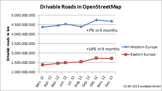
The drivable road network continues to grow in Western and Eastern Europe. While some countries like Germany have more or less reached 100% coverage of the driveable road network, others still have potential. In Eastern Europe I want to stress the growth of Turkey by 39% and Russia by 19%. In Western Europe we see Spain growing by 18% and France by 19%.
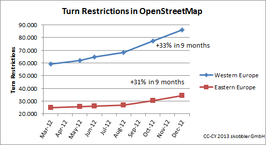
Turn restrictions show a strong growth – Eastern and Western Europe alike. Saturation has not been reached in any country –even Germany has grown by 34%.
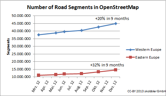
The overall growth of road segments shows an uptake after the license change had been completed.
Overall we see stronger growth in Eastern Europe, which means the gap between Eastern and Western Europe is narrowing.
This is showing just an extract of available data but allows extrapolation with a good confidence level. If you have questions don’t hesitate to contact me.
As last year, Ryerson University is providing a dry roof overhead, lots of space, and rock solid wifi for the software development portion of event.
There will also be a public event, possibly an expert panel, Friday afternoon at Ryerson. Details to follow.
Also as last year, there will be a ton of socializing and meeting and greeting with the local OSM community Friday night and Saturday night.
And there are sponsorship opportunities! Want to sponsor a core developer who could otherwise not participate? Want to buy the coders dinner and a few drinks? Let me know.
December 30th, 2012 – January 13th, 2013
A summary of all the things happening in the OpenStreetMap (OSM) world.
Did we miss something? You can contact us via weekly.osm@googlemail.com
Authors: Pascal & Dennis – (thx @ “Wochennotiz”)
OpenStreetMap has just passed 1 million users! That’s a million people who have signed up on openstreetmap.org to join in with creating a free map of the world.
At first glance you may think that OpenStreetMap is a map. Those who know more will tell you that it’s actually a database; a flexible editable repository of free geospatial data. But above all OpenStreetMap is a community. A massive community in which people like you and me come together collaborate and help build this thing… and now there’s a million of us!

A massive community is what makes OpenStreetMap work. We need many people to sign up, and we need those people in every neighbourhood, in every corner of the globe, to chip in a little bit using our editing tools. In this way we have grown and progressed spectacularly throughout 2012. This wonderful video illustrates what a great year of map editing activity we had.
Who will join the OpenStreetMap community in 2013?

What is the best song for your music player while you survey data for OpenStreetMap? Can you keep yourself entertained and inspired with a great playlist while you survey, or is the music too distracting? Are there songs that remind you of mapping? In past, some have suggested specific songs as anthems for mappers.
The following songs each have the words open, street, and map in them, though not in the string we prefer.
Are there more songs with the words Open, Street, and Map in them? Which songs or music would you suggest as a mapping anthem, or to inspire and motivate your surveys? Use the comments below to discuss. I’ll add some CanCon suggestions tomorrow.

A small sample of the South Africa aerial imagery provided by CD:NGI, the mapping agency of the government of South Africa.
OpenStreetMap contributors in South Africa have negotiated with the South African government to arrange the donation of some aerial imagery to be used in creating and editing data for OpenStreetMap. Chief Directorate: National Geo-Spacial Information, or CD:NGI, part of the South African Department of Rural Development and Land Reform, have provided aerial imagery and OSM contributor Grant Slater, has prepared it for use in our editors. There is 3TB of imagery and covers all of South Africa.
Thanks as always to the many people who helped make this happen: the fine folks at CD:NGI, the OSM contributors who carried the data between continents, and the mappers who continue to make OSM data better, more up to date and accurate every day.
You can find more information about this aerial imagery in the thread on the talk-ZA mailing list.
Do you want to donate aerial imagery or other data to OpenStreetMap? Contact the OSM Foundation Communication Working Group for more details. communication@osmfoundation.org
The OpenStreetMap Foundation is a not-for-profit organization, formed in the UK to support the OpenStreetMap Project. It is dedicated to encouraging the growth, development and distribution of free geospatial data and to providing geospatial data for anyone to use and share. The OpenStreetMap Foundation owns and maintains the infrastructure of the OpenStreetMap project. You can support OpenStreetMap by donating to the OpenStreetMap Foundation.

OpenStreetMap birthday cake from the 8th OSM birthday party in Tokyo, Japan.
December 16th, 2012 – December 30th, 2012
A summary of all the things happening in the OpenStreetMap (OSM) world.
Did we miss something? You can contact us via weekly.osm@googlemail.com
Authors: Pascal & Dennis – (thx @ “Wochennotiz”)