Category Archives: Uncategorized

Weekly OSM Summary #32

November 28th, 2011 – December 12th, 2011

A summary of all the things happening in the OpenStreetMap (OSM) world.

  • You can donate for the new OSM server! A list of all donators so far can be found here.
  • Since November 27th, 2011 the OSM project has more than half a million registered members and a few days later the 10 millionth changeset was created.
  • Last week a new set of e-mails has been sent to all users who did not agree to the new contributor terms yet (No. 5 in the LWG minutes). You can follow the development by checking the statistics after December 7th here.
  • You can find the current status of a user’s agreement to the new contributor terms at each user’s OSM page now. For example: http://www.openstreetmap.org/user/Firefishy
  • The Strategic Working Group is collecting suggestions/comments from the OSM community about the future direction of the project. You can find it in the wiki.
  • Help the OSM Foundation to communicate with more Mapppers in their native language.
  • The call for venues for the next State of the Map conference 2012 is open now.
  • The Weekly OSM Summary is now also available in Spanish, gracias Chile!
  • A FLOSS manual about OpenStreetMap – A really nice overview about OSM, Mapping tools and other important things.
  • A „3D Dev weekend“ for developers of OSM 3D is planned for March 2012. You can find some more information here.
  • Two attorneys in the USA have been asked whether the OSM map data falls under copyright or not. Read more here.
  • The OpenLinkMap is back online. Find out more about it here.
  • With ShareMap you can create your own map and present it in several formats like SVG, bitmap raster or interactive web map. Try it out here.
  • A nice animation about the edits in Prizren (Kosovo) made by geocommons.
  • Konstantin Käfer created a tiled version of Gregor Aisch’s map “Streets of Berlin” inspired by Fathom’s “All Streets” map.

Did we miss something? You can contact us via weekly.osm@googlemail.com

Authors: Pascal & Dennis – (thx @ “Wochennotiz”)

Languages and OpenStreetMap Foundation

Photo by R. Steven Rainwater

In March 2011 the Communication Working Group tried to make the OSMF accessible to more people by posting in more languages. As a test we added German and French to the OSMF Blog. We’re still working on improving this by making each article available. But this experiment is already a success based on the feedback that we are getting from you.

It has been successful because of the volunteers who add the translations. Thanks go to Daniel Begin and Michael Schulze for helping us reach out to more mappers in French and German.

Shortly we’ll add Russian translations as well thanks to Eugene Usvitsky. Our web statistics tell us that Russian speakers are the next-most-frequent visitors to the OSMF site. The OSMF wants to reach out in other languages as well. Would you like to help? The workload is irregular and you can work from home. 🙂 If you are interested, contact the Communication Working Group at communication@osmfoundation.org

We will consider adding translations to the site for any language except perhaps Klingon; we’re undecided on Klingon. If you can help with some of the languages that are more-frequently used in OpenStreetMap, please let us know.

If you would like to test us out first, and see how you like working with the Working Groups on a smaller, temporary project, the License Working Group has a small translation project that you can help with right now. Contact legal@osmfoundation.org if you would like to help with Czech, Chinese, Swedish, Finnish, Japanese, Hungarian, Romanian, Norwegian, Slovakian, Greek, Korean, Turkish or Croatian.

Klingon photo by R. Steven Rainwater on Flickr is licensed CC-By-SA

Improving OpenStreetMap reliability and performance

macro photo of pound coins

OpenStreetMap is growing fast. We’ve recently welcomed our 500,000th signed up user, and we’ve logged our 10.000.000 th update to the map. Over the next few weeks we’re running a fund-raising drive while we invest in server infrastructure to improve reliability and performance of OpenStreetMap. If you’d like to support the project in this way, or you know anybody else who would like to give OSMers an early Christmas present, visit our fund raising site:

http://donate.openstreetmap.org/server2011

You have the option to include your name on the donors list. We’re aiming to raise £15,000 (~ 23,000 U.S. dollars). Let’s see how quickly we hit the target!

We wanted to run another fund raising drive, because last time we had a big one was back in 2009 (old blog post) and we were blown away by how quickly we raised the target amount. It seemed as though people were looking for an outlet for their generosity and goodwill towards the project. Since we’re planning to buy a new server, now seems like a good time to do it again.

The Operations Working Group, which has the important role of keeping core OSM services running smoothly, plans to invest in a new server. This will provide us with a database replica. This improvement is at the very core of the OpenStreetMap infrastructure, giving services greater resilience. It means we’ll bounce back quicker and easier in the event of a hardware failure. In time the new server will also bring about some performance improvements. We have a wiki page with more technical details and plans for the new hardware.

We hope you’ll agree that, although these improvements are very much behind-the-scenes, they are important. Please give generously to help make them happen!

Photo credit: Pound coins by William Warby CC-By-SA

The next OpenStreetMap conference

We’ve had 5 great State of the Map conferences. Manchester, Limerick, Amsterdam, Girona and Denver. Big question is: where are we going to be in 2012?

We would like to have your help with finding a great venue for the largest annual OpenStreetMap conference.

Would you like to have the 2012 edition of State of the Map in your city? Submit your proposal on our Call for Venues page on the wiki. More details about criteria and the information we would like to have from you can also be found at that wiki page.

We hope to announce our 2012 venue in the beginning of the new year.

Half A Million And Counting

We reached 500,000 registered OpenStreetMap users last night. Yes. That’s an army of half a million people who can edit OpenStreetMap!

This project is all about mass collaboration. Thousands of people coming together on the internet to build something great: a free map of the world. If you’d like to join these ranks, head to openstreetmap.org and hit the sign up link in the top right hand corner. We’d love to have you!

When you have an account on OpenStreetMap.org you can edit and add to the map. This is what it’s all about. We need lots of people, not just to join, but to progress on to the next step where the fun really starts. Zoom in on your neighbourhood and move across to the edit tab, to enter the map editing interface. If you didn’t already try this (we know there’s lots of you), give it a go today! Contact the community if you have any questions or problems. Let us know what’s holding you back. In recent months we’ve made great strides in making it easier to edit the map, with a stream of innovations from developers of the editors, and initiatives to create new documentation. But there’s plenty more work to do on this, so that OpenStreetMap can reach a million users, and (more importantly) so that all these users will have a go at editing!

Weekly OSM Summary #31

November 14th, 2011 – November 28th, 2011

A summary of all the things happening in the OpenStreetMap (OSM) world.

  • The OSM Foundation is planning the final steps to switch to the new license. Read the full blog post here. Also, the Licensing Working Group (LWG) announced some information about the database re-build here.
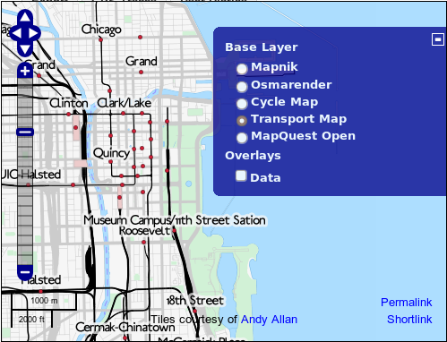
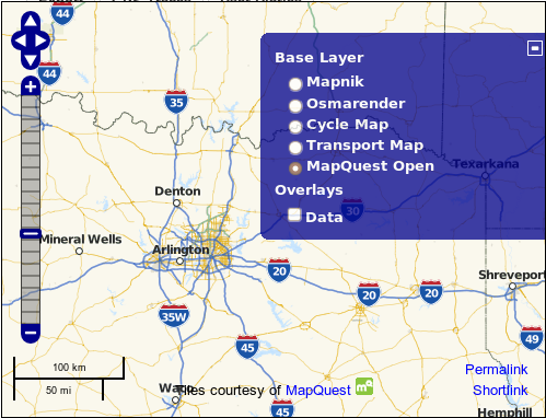
  • The OSM.org website had a minor update. You will find two new selections in the layer switcher in the upper right corner. The Transport Map by Andy Allan and the Open.Mapquest map.
  • The German OpenStreetMap community has a new website too. You can find a blog post about the new layout and design here.
  • Some important information from our Humanitarian OSM Team (HOT). All members need to confirm their membership. Read the full text here. Further the HOT Team is asking for help for their Samoa simulation.
  • First results of the new Engineering Working Group (EWG) can be found here.
  • More information about the past Hackweekend in London can be found here.
  • The Portugal community turned in a proposal to host the upcoming SOTM 2012. Read it here.
  • Pascal conducted a new analysis of the OSM Inspector routing view.
  • In preparation for Christmas: A XMAS Map.
  • “The Brave Mappers Project – The story of OpenStreetMap in Amsterdam in pretty shapes and colors” by Martijn.
  • Peter developed the new “OSM History Renderer” tool. It creates your own OSM history animation. Find his project and an example for Karlsruhe (Germany) at github.
  • Two employees of the Massachusetts Department of Transportation created a more US style tileset. You will find the github URL and the map URL here.
  • ITO World created a new US road fatality map using OSM as a basemap.
  • With World Airport Codes the next website changing to OSM has been introduced. Read more about the change here.
  • Osm2pgsql is used for example to create a database for rendering OSM data. The latest version of this tool has several updates. It would be great to gather some benchmarks now.
  • Jochen created a plug-in for QGIS that allows the user to use the JOSM remote control feature.
  • The Overpass API has now a mirror in Russia. What is the Overpass API and what can you do with it?

Did we miss something? You can contact us via weekly.osm@googlemail.com

Authors: Pascal & Dennis – (thx @ “Wochennotiz”)

New ways to see OpenStreetMap data

Two new tile sets are now featured on the OpenStreetMap.org site. The
Transport Layer and the MapQuest Open layer both use the same Hot
Fresh OpenStreetmap data that we all know and love. Each tile set
presents that data in a different way, for a different audience by
making careful choices about how to render OpenStreetMap data.

The Transport layer, courtesy of Andy Allan shows public
transportation infrastructure like subways and bus routes and train
stations.

Media_httpiimgurcomcz_eqasq

The MapQuest Open layer, courtesy of MapQuest shows highway shields and toll
roads.

Media_httpiimgurcomt9_fjfkm

Classroom OpenStreetMap workshop

OpenStreetMap contributor Ilya Zverez reports on recent OSM workshops
in Russian classrooms.

Recently there were three mapping lessons in small towns of Perm
region, Russia. It went very well, from collecting data to drawing
maps in Potlatch. At the last meeting they even tried to send a
weather baloon with a camera (but photos were no good because of
strong wind). Here is project page, in Russian, but google-translated:
http://translate.google.com/translate?hl=en&sl=ru&tl=en&u=http%3A%2F%2Fosm.pe…
Photos and reports are in the wiki, also in Russian. One of major TV
channels covered it: http://www.5-tv.ru/news/47596/

OpenStreetMap used by TripAdvisor

OpenStreetMap contributor Harry Wood tells us
about a new application.

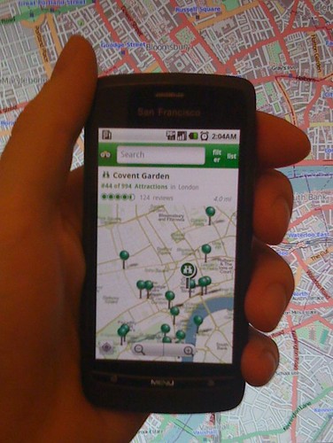
TripAdvisor have launched a set of free android apps providing city
guides for 20 popular world cities, and for the maps they’ve used
OpenStreetMap!

Each of the following cities has a dedicated app on the android marketplace: Amsterdam, Barcelona, Beijing, Berlin,
Boston, Chicago, Florence, Hong Kong, Hawaii, Las Vegas, London,
Los Angeles, New York City, Orlando, Paris, Rome, San Francisco,
Sydney, Tokyo, and Washington D.C., and each one comes with
OpenStreetMap in a nicely themed green colour scheme.

TripaAvisor Adroid app showing OpenStreetMap

TripAdvisor.com is one of the
largest travel websites on the web. You may know them for their hotel
and restaurant listings with user reviews. These are all available
within the app, and overlaid on the maps (although it should be noted
that they’re not using OSM for the locations of these things, and in
places it looks like they could use a bit of iterative wiki-style
improvement to their accuracy!) but we’re delighted to see them
taking OpenStreetMap data and rendering it in their own style. The
maps are also available offline, allowing travellers to avoid data
roaming fees.

Weekly OSM Summary #30

October 31th, 2011 – November 14th, 2011

A summary of all the things happening in the OpenStreetMap (OSM) world.

Did we miss something? You can contact us via weekly.osm@googlemail.com

Authors: Pascal & Dennis – (thx @ “Wochennotiz”)