I convey the following information on behalf of the Board of Directors of the OpenStreetMap Foundation.
An outcome of the current controversy on the osmf-talk mailing list over misogynistic language is a decision by the Board as follows:
The Board will find partners to help instate a moderator team for the OSMF-talk and talk mailing lists. These moderators need to have the trust of the community subject to the moderation (consent of the governed) by some kind of approval mechanism.
This moderator team will start to work on enforcing the current Etiquette guidelines as soon as possible. We will also start work on updating/replacing our Etiquette rules, which must focus on balancing all participants’ interests.
We have asked the Local Chapters and Communities Working Group (LCCWG) to take the lead on this and to work with signatories of the open letter to the Board as well as members of the Diversity and Inclusion Special Committee to produce proposals for the Board to consider at its January meeting. The LCCWG has accepted this task. This issue will be on the agenda of the January meeting of the Board of Directors, exact time and date yet to be determined, though as is customary it will be posted to the Foundation’s website well in advance.
Members of the OSM community are, as always, welcome to share their opinions and any relevant information on this matter, either publicly via osmf-talk, or privately in direct communications to the LCCWG. I feel compelled to remind all members of the community that a Code of Etiquette has existed since June 2011 and shall be observed by all community members.
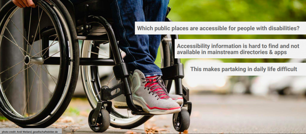
The International Day of Persons with Disabilities is observed every December 3rd, and OpenStreetMap marks this day by saying “Our aim is to be the best world map for accessibility”. OpenStreetMap has long been a resource to map and share open data on features related to disabilities.
We asked community members gathered on the accessibility mailing list about why and how OpenStreetMap is so useful.
Jean-Marie Favreau of the Université Clermont Auvergne explained…
The strength of OpenStreetMap is that it allows anyone to contribute accessibility data, whether they are local authorities, user associations, or individual contributors. Being a global project, it facilitates the sharing of observations and learnings of how the equipment, habits and practices of accessibility vary in different coutnries. Finally, the data is in a commons and managed by a community, so it more accurately reflects the reality of the territories it maps.
Nick Bolton of the University of Washington adds…
When people with disabilities seek out map information, they find that accessibility information is missing or doesn’t account for their personal preferences; neither companies nor government agencies are consistently creating connected pedestrian map data flexible enough to meet the diversity of pedestrian concerns expressed by people with disabilities. OpenStreetMap is well-suited to fill this informational gap as it has a flexible and democratically extensible data model, can be mapped out by locals without waiting for an agency or company to dedicate resources or take on liabilities, and all data is immediately published and examined by the public.
We are so glad OpenStreetMap fulfills this need. Read on to learn about applications for persons with disabilities, and ways to contribute to the map.
Apps for accessibility
There are many applications and research projects for persons with disabilities that use OpenStreetMap for collecting and sharing accessibility data, and for communicating that data in appropriate ways.
Data on sidewalks is critical to accessible navigation. OpenSidewalks focuses on developing tagging schemes and tools for collecting accessibility data of sidewalks, and its sister project AccessMap creates individualized accessible routing plans for people with mobility impairments. Both are projects of the Taskar Center at the University of Washington. This approach has been picked up by the Italian OpenStreetMap community in Padova and Milan, with people with disabilities, high school students, and other new mappers contributing.
And then there is navigating indoors. AccessbileMaps is a project of the Technische Universität Dresden in cooperation with the Karlsruher Institut für Technologie and focuses on indoor accessibility. They develop tools for mapping buildings with the Simple Indoor Tagging scheme, especially accessibility information, and produce applications using indoor data from OSM for blind, visually impaired and mobility impaired people to plan trips.
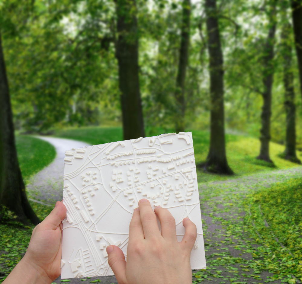
Touch Mapper 3d printed tactile map in use
Then this data needs to be used in appropriate ways, and the creativity and innovation is inspiring.
Tactile maps help people who are blind or partially sighted navigate their surroundings. Touch Mapper uses 3D printing to create tactile maps from OSM data.
Soundscape from Microsoft Research helps users with visual disabilities to create better mental maps of their surroundings for navigation. Using audio to describe places, they can naturally and intuitively explore more and feel more comfortable and connected in new environments. The app is built on OpenStreetMap data.
Compas research project at the University Clermont Auvergne develop ACTIVmap in partnership with other academic and private sector researchers to build multimodal maps leveraging tactile, sound and haptic feedback to represent and interact with geographic information.
How can you help?
a screenshot of editing accessibility information in a StreetComplete quest
You can of course also add disability-related tags with regular OpenStreetMap editors like JOSM and iD, and mobile apps like Vespucci, StreetComplete, OsmAND, and Go Map!!
Traffic signals with sound (traffic_signals:sound=yes/no)
Accessibility information for steps, such as the presence of handrails (handrail:left/right/center=yes/no), the number of steps (step_count=*) as well as whether there is a ramp (ramp=yes/no) and which kind
Wheelchair accessibility at shops and other amenities (wheelchair=yes/limited/no) as well as bathrooms (toilets:wheelchair=yes/no)
There are many other ways to help, documented on the wiki as well. For example, promote OpenStreetMap with friends who have a disability, and ask them how else OSM can help. You could organize a mapping party focused on mapping these kinds of features. Translate our wiki pages on disabilities to other languages. Or build new routing and rendering applications for people with disabilities.
OSM’s freeform tagging system is always evolving, if there’s something you think should be mapped in OSM, but isn’t, you can help guide that process to wider adoption.
The International Day of Persons with Disabilities is observed every December 3rd, and OpenStreetMap marks this day by saying “Our aim is to be the best world map for accessibility”. OpenStreetMap has long been a resource to map and share open data on features related to disabilities.
We asked community members gathered on the accessibility mailing list about why and how OpenStreetMap is so useful.
Jean-Marie Favreau of the Université Clermont Auvergne explained…
The strength of OpenStreetMap is that it allows anyone to contribute accessibility data, whether they are local authorities, user associations, or individual contributors. Being a global project, it facilitates the sharing of observations and learnings of how the equipment, habits and practices of accessibility vary in different coutnries. Finally, the data is in a commons and managed by a community, so it more accurately reflects the reality of the territories it maps.
Nick Bolton of the University of Washington adds…
When people with disabilities seek out map information, they find that accessibility information is missing or doesn’t account for their personal preferences; neither companies nor government agencies are consistently creating connected pedestrian map data flexible enough to meet the diversity of pedestrian concerns expressed by people with disabilities. OpenStreetMap is well-suited to fill this informational gap as it has a flexible and democratically extensible data model, can be mapped out by locals without waiting for an agency or company to dedicate resources or take on liabilities, and all data is immediately published and examined by the public.
We are so glad OpenStreetMap fulfills this need. Read on to learn about applications for persons with disabilities, and ways to contribute to the map.
Apps for accessibility
There are many applications and research projects for persons with disabilities that use OpenStreetMap for collecting and sharing accessibility data, and for communicating that data in appropriate ways.
Data on sidewalks is critical to accessible navigation. OpenSidewalks focuses on developing tagging schemes and tools for collecting accessibility data of sidewalks, and its sister project AccessMap creates individualized accessible routing plans for people with mobility impairments. Both are projects of the Taskar Center at the University of Washington. This approach has been picked up by the Italian OpenStreetMap community in Padova and Milan, with people with disabilities, high school students, and other new mappers contributing.
And then there is navigating indoors. AccessbileMaps is a project of the Technische Universität Dresden in cooperation with the Karlsruher Institut für Technologie and focuses on indoor accessibility. They develop tools for mapping buildings with the Simple Indoor Tagging scheme, especially accessibility information, and produce applications using indoor data from OSM for blind, visually impaired and mobility impaired people to plan trips.
Touch Mapper 3d printed tactile map in use
Then this data needs to be used in appropriate ways, and the creativity and innovation is inspiring.
Tactile maps help people who are blind or partially sighted navigate their surroundings. Touch Mapper uses 3D printing to create tactile maps from OSM data.
Soundscape from Microsoft Research helps users with visual disabilities to create better mental maps of their surroundings for navigation. Using audio to describe places, they can naturally and intuitively explore more and feel more comfortable and connected in new environments. The app is built on OpenStreetMap data.
Compas research project at the University Clermont Auvergne develop ACTIVmap in partnership with other academic and private sector researchers to build multimodal maps leveraging tactile, sound and haptic feedback to represent and interact with geographic information.
How can you help?
a screenshot of editing accessibility information in a StreetComplete quest
You can of course also add disability-related tags with regular OpenStreetMap editors like JOSM and iD, and mobile apps like Vespucci, StreetComplete, OsmAND, and Go Map!!
Traffic signals with sound (traffic_signals:sound=yes/no)
Accessibility information for steps, such as the presence of handrails (handrail:left/right/center=yes/no), the number of steps (step_count=*) as well as whether there is a ramp (ramp=yes/no) and which kind
Wheelchair accessibility at shops and other amenities (wheelchair=yes/limited/no) as well as bathrooms (toilets:wheelchair=yes/no)
There are many other ways to help, documented on the wiki as well. For example, promote OpenStreetMap with friends who have a disability, and ask them how else OSM can help. You could organize a mapping party focused on mapping these kinds of features. Translate our wiki pages on disabilities to other languages. Or build new routing and rendering applications for people with disabilities.
OSM’s freeform tagging system is always evolving, if there’s something you think should be mapped in OSM, but isn’t, you can help guide that process to wider adoption.