Monthly Archives: December 2016

OpenStreetMap Recap 2016

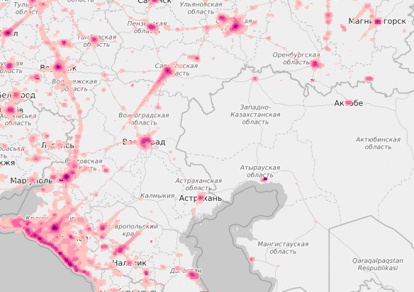
a new year’s firework display hidden in the OpenStreetMap tile viewing data

So yet another year has passed with so many new and exciting things. With a history of more than 12 years we have built a huge community with many success stories, large and small, and we want to share a brief recap of interesting things that happened this year.

The OpenStreetMap Foundation’s board did some small changes that seem to be well received by the community, mainly a significant increase in the board’s transparency; e.g. board meetings are now open to the public and all members are allowed to tune in and even participate in board meetings. Besides that, the Foundation is experimenting with an assistant who was hired to help with a bunch of administrative tasks to support the board and at times the Working Groups. And as mentioned in the manifestos of the two board members that stood for re-election in this year’s board elections, the current board are respectful to each other and are working together very well.

Speaking of the Foundation, there is a new Corporate Membership Program that has been introduced towards the end of 2016. It features different tiers, with fees from €500 per year up to €20,000 per year. The program officially starts in January 2017 and already great interest has been expressed in it with two imminent/upcoming/ gold memberships. Together with the first general successful donation drive that raised €70’000 we’re in good shape for the year 2017 to keep our financial Independence as a community project.

We also need to mention the forming of two new Local Chapters this year. In February the Italian Local Chapter got accepted as officially recognized, and only a few months later the Swiss Local Chapter followed. We’re very happy about the formation of Local Chapters, and we expect there are more to come soon: The German FOSSGIS e.V. is considering applying in 2017.

During the year we participated again in the Google Summer of Code, with six very interesting student projects which were worked on during summer. And if we get accepted, we’re sure to participate in 2017 again.

But not everything was good news this year. The German community -no, the global community- had a huge loss with the death of Malenki. He was known to many of us for his kindness, helpfulness, the many projects he worked on and his very active mapping history. RIP.

The Wochennotiz, the German version of the well known weeklyOSM, had an anniversary this year: It’s 300th issue. And as weeklyOSM is translated in different languages and is always seeking to extend its visibility, we might see new languages added in 2017. Right now the issues are released in 8 different languages.

The UK community has continued with actively pursuing its Quarterly Project to have a special mapping task that the community tries to collaboratively work on for three months. A story of success and perhaps a good example for other local communities for 2017?

With a new head of SotM Working Group and a great and active local team we had a great State of the Map. It was a lot of fun to see so many people from our community joining from all over the world. It was a great success, for the community and also financially. Besides the many great talks we had the OSM-Awards for the first time to honor volunteers in our community in different categories and we expect to see a repeat of these awards at another great State Of The Map conference in Japan in 2017.

But there was more than just our international SotM. There have been many local conferences, too, which allow a wider and local audience to participate. We’ve had a SotM Latam in São Paulo, Brazil, a SotM Asia in Philippines, the FOSSGIS-Conference in Salzburg, Austria, a SotM US in Seattle, Washington, a SotM Cz in Brně, a SotM FR in Clermont-Ferrand and a SotM JP in Tokyo.

Normally the work of our Licensing Working Group is not so publicly visible and this year has been tough as four of the seven members have had babies. So less volunteering time for LWG, but new blood for OSM! Anyway, there still have been two achievements that had a bit of a wider audience. After a long history of drafting, collecting feedback, updating, asking for further comments, updating again, the LWG finally managed to publish the new Collective Database Guideline which was approved by the OSMF board. In a similar matter, the LWG updated the Privacy Policy to fix some longstanding shortcomings of the old version. For example the policy now clearly states what gets logged and how that is used and a detail around how the sharing of data with respect to Gravatar profile pictures works.

Of course there are more Working Groups that do volunteer work. Only this year the new Membership Working Group was formed. This group are administering the membership database, answering to membership queries but is also tasked to increase the OSMF membership. Additionally, there is the Data Working Group and the Operations Working Group who are doing great and extensive work. However, you know those groups are doing good work, if you don’t hear too much of them 🙂 And last but not least there’s the Communications Working Group who are writing blog articles like this one for you.

We want to say a huge Thank you to everyone who participated in one of our Working Groups, in the Foundation or in our project in general. You’re the ones that make our project and our map so great and who made this year a story of success like the years before. Happy new year to everyone, keep up the good work and see you in 2017!

Tips for new (Pokémon GO) mappers

Some tips for our new mappers coming from Pokémon GO:

So, you want to find rare spawns and came to edit OpenStreetMap? Welcome to our community of people passionate about collaboratively building the best map ever!
Please,

  • do improve the map!
  • do map things that exist on the ground. The map is used by pedestrians, people with disabilities, cyclists, hikers, canoeists, drivers and others. Do not add things -such as footways- that do not exist
  • do add things you see (i.e. benches, cafes, fire hydrants, bicycle parking spots) or things you know (if your favorite cafe offers free wifi, the type of cuisine of the nearby diner, accessibility, opening hours, official websites, wikipedia links)
  • want to add footways? Check what is considered as a footway: highway=footway tag docs. Want to add other features? Have a look at map features and search the wiki
  • do connect your footways with the road network
  • tagging secondary institutions? Use amenity=school. Tagging universities? Use amenity=university
  • do you still have questions? Ask away at help.openstreetmap.org
  • do connect with the community! Find your country’s forum, mailing list/twitter account or other contact channel
  • do not add copyrighted data from other maps/sources
  • do find other mappers that improve your neighborhood/city e.g. with the oooc map (you need to have contributed a bit before your nickname is shown)
  • do check your own stats after you have contributed a bit! e.g. here
  • do check existing events
  • do mention “pokemon” in your changeset comments and a few words about what you added/changed. That will help your neighbor mappers to check the changes you make and maybe provide tips
  • do contribute your GPS traces, especially if you live in a rural area
  • do check the good practice guidelines for more tips

You and over three million of other contributors make OpenStreetMap possible. Welcome to our community – be excellent to each other and enjoy mapping our pale blue dot!

Pokémon Go?

We’ve recently seen a flurry of new map editing activity from “Pokémon GO” players. Although this hugely popular mobile game displays maps from google maps (in fun colours), it seems it may be using OpenStreetMap data (according to some players) to influence “spawn points” within the game.

This is interesting for several reasons. We always like to see creative and unexpected uses of our free and open map data, and this certainly fits into that category! (Note: our open license does require crediting OpenStreetMap)

There is some new interest in editing the map from Pokémon GO players, presumably because the game is found to be bringing in updates when changes are made to OpenStreetMap. It always takes new folks some time to get to know OpenStreetMap, and we hope Pokémon GO players will stick around to contribute some more. We’ve prepared the above guidelines to help understand some aspects of OpenStreetMap related to the game.

OpenStreetMap is a world-wide collaborative project aiming at providing free map data, under an open license, to anyone who wants it. Volunteers all over the planet contribute their local knowledge and their time to build the best map ever.
You can contribute by improving the map, editing or translating the wiki, becoming a member of the volunteer Working Groups, increasing awareness about the project, uploading GPS traces, donating (donate.openstreetmap.org) or joining the OSM Foundation. You don’t have to be a member of the Foundation in order to edit OpenStreetMap.

Board election results 2016

Last week we held our 2016 Annual General Meeting and foundation members have voted for Kate Chapman and Frederik Ramm to continue serving on the board. Congratulations to both of them!

Election time is always a great opportunity to get various ideas heard, so thanks to Darafei Praliaskouski and Guillaume Rischard for being nominees and hope to see your nominations again next year. You can read all the manifestos online. Special thanks also go to Dermot McNally for handling the polling.

As another mapping year comes to an end, you can read the chairperson’s report for 2016 from Kate Chapman and the treasurer’s report from Frederik Ramm.

Don’t forget that you can influence the direction of the project both by participating and by voting for the board. So, join the Foundation to take part in such elections!

Chairperson’s Report for the OpenStreetMap Foundation 2016 Annual General Meeting

Note: If you are a member of the OSMF you can find more information on the meeting here.

Thank you to everyone who contributed to OpenStreetMap in some way this year. If you mapped, coded, presented or otherwise helped us on our journey to create free map of the entire world this means you. It is an honor to be able to support this community through my role at the OpenStreetMap Foundation and as a community member. 
On behalf of the Foundation thank you to everyone who participated in the organization that supports the continued existence of the project. At the center of this is the Working Groups: without our working groups the core technical services wouldn’t run, we would not have the legal infrastructure to effectively run the project, State of the Map wouldn’t happen, mapping disputes wouldn’t have resolutions, official communications wouldn’t exist, and membership would still be run entirely by the board. Much of the Working Group work is thankless, if you are on a Working Group and see me in the next year please remind me to buy you a beer (or other beverage of choice). 
Members, if you have been a member for years or this is your first AGM I appreciate you. Please continue to state your needs and if you haven’t please speak up. If you are so inclined help us recruit members for 2017. The membership should serve to keep the board on task and I hope someday it will represent the diverse world that we map. 
To the Board Members both new and old, sometimes it is hard to see the forest through the trees. Looking back on this year I think we’ve made some real accomplishments. Sometimes they may not feel like much but they are important the year things we have accomplished:
  • Increasing board transparency by having open board meetings and thanks to Peter especially, communicating generally with the membership sooner.
  • We also had our first community member audit of the financial records.
  • Developing an open-source policy to guide what tools we use to run the OSMF Board
  • Creating and filling of Admin Assistant Role to help make sure the day to day work is done more efficiently.
  • Successfully funding and hosting a donation drive to cover the general operating costs of the OSMF over the next year
  • Updating the Corporate Membership to increase the value of the membership and have it serve as a greater funding base for the OSMF in the future.

Membership Statistics

Here are the regional statistics regarding membership in the OSMF for 2016 with reference to 2015. The regional membership breakdown has changed slightly. 
  • Europe and Central Asia 68.18% [last year 70%]
  • America South, Central, North and Caribbean 22.73%  [last year (USA&Canada) + (Latin America): 23% + 1.5%]
  • Middle East and North Africa 0.65  % [last year 0.5%]
  • Africa West, East, Central and Southern 1.08% [last year 0.5%]
  • Asia-Pacific 7.36%  [last year 4.5%]

Looking Forward

We have made some major steps forward this year, but we have a long way to go. Through my day job work in non-profits we often talk about “what is the vision?” and “how can we get there?” For OpenStreetMap our job will never be done, but we would be well on our way to accomplishing our vision by having equal quality data of the entire world. There are things the OSMF must look towards in the coming year and beyond for that to happen:
  • Supporting mappers is at the core of what we do. Without mappers there is no map
  • Increasing the funding base of the OSMF. This year we have put some pieces in place to allow that but in the next year we must continue to move towards that. This includes getting organizations to sign-up for new levels of corporate membership and successfully running another donation drive.
  • Diversifying the membership of the OSMF (and in the future the board, since that will not happen this election)
  • Providing more clear ways for financial support of Working Groups and Communities

Over the past year I’ve had the privilege to meet OSM contributors on four continents. If I haven’t had the opportunity to meet you please don’t hesitate to reach out. In 2017 I will at the very least be in Australia, the United States, Japan and parts of Europe (not sure which yet). Even if you just want to chat let me know so I can thank you for your contributions and get your feedback. Let’s all continue to make a great map in 2017.

Announcing the 10th State of the Map

Come 2017 it will have been 5 years since the international community gathered in Asia. Today we are delighted to announce that we will be back in Japan for the annual ‘State of the Map’ gathering:

State of the Map will be in Aizuwakamatsu, Japan.
Schedule will be 18th-20th August (with potential for events on 17th August).
Tickets will be on sale in spring 2017.

Tsuruga Castle (c) Sonotoki (CC BY-NC-ND 2.0)

We had some amazing bids this year and the working group has spent time reviewing these with the local groups – thank you for support. Aizuwakamatsu is a brilliant place for us to gather as a community next year. It is a city in the Fukushima Prefecture some 260 km (160 mi) north of Tokyo. With a long history and many attractions it will also make the perfect place for some sightseeing.

Stay tuned to this blog, and our twitter account @sotm, for more news and how you can participate in State of the Map 2017. It’s always exciting for contributors, consumers, developers, teachers, and everyone in-between to come together and share what’s happening in the OpenStreetMap project. We look forward to seeing you in Japan!