Category Archives: Uncategorized

OpenSlumMap

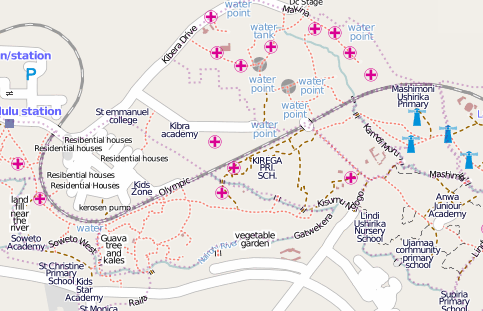
Mikel parachuted in to Kibera last month – a holiday destination known as the “second largest urban slum in Africa” – to make sure it’s all mapped. The results have been impressive:
Untitled

It includes a website, map data of course and social media including twitter and interviews:

The press release is worth a read:

Kibera remains a blank spot on the Kenyan map, though it holds as many as one million inhabitants according to UN-HABITAT. Its limited health and water resources, traffic patterns, and housing layouts remain largely invisible to the outside world and to residents themselves. Though many organizations have collected data on Kibera, the information is not yet shared as a resource for all to use. Map Kibera will fill in this gap by producing free, open-source digital map data using the techniques of OpenStreetMap, a user-edited map of the world. The resulting information will be freely available to residents, NGOs, private companies, and others interested in working with and for Kibera.

ESRI User Conference in July

img_1835
Our humble abode for three days, at the ESRI User Conference in San Diego in middle July. Emma Lyons (Cloudmade’s summer intern) and I had a great time running this booth. We put it together pretty frugally, with a table drape for a sign, a couple of photo frames cycling through Best of OSM images. We gave away huge numbers of buttons and pens, and after the first day, we had Cloudmade-sponsored OSM T-Shirts to give away. Oh, we surely got popular THEN! Talked to a lot of people about OSM. I used the line “Can I tell you about OpenStreetMap?” if anybody paused. Most people stayed to listen to my 30 second spiel. The booth cost us nothing because we were representing a non-profit, and given the contacts we made, was definitely worth the time. I encourage everyone to seek out opportunities to represent OSM at a trade show.

Then you win: Ordnance Survey to open data

“First they ignore you, then they laugh at you, then they fight you, then you win.” – Gandhi.

See story here.

The Prime Minister and Communities Secretary John Denham will today announce that the public will have more access to Ordnance Survey maps from next year, as part of a Government drive to open up data to improve transparency.

Speaking at a seminar on Smarter Government in Downing Street later today, attended by Sir Tim Berners-Lee and Professor Nigel Shadbolt, the Prime Minister will set out how the Government and Ordnance Survey, Great Britain’s national mapping agency, will open up its data relating to electoral and local authority boundaries, postcode areas and mid scale mapping information.

Ericsson Labs OSM library

Ericsson labs have released an OSM library:

A couple of months ago we released support for OpenStreetMap maps for our Web Maps API and the Java ME version of the Mobile Maps API. We are now happy to release it for the Android version of our Mobile Maps API. Mobile Maps for Android with OpenStreetMap allows any developer to integrate the maps from the OpenStreetMap project into any Android application and have them rendered in the fast and dynamic Mobile Maps engine.