Author Archives: Richard Weait

What would it take to map an entire country?

“What would it take to map an entire country?”

With the growing visibility of Map Kibera, that question is coming
more frequently, especially in Africa, where both OpenStreetMap and
traditional mapping are widely absent. This is a massive question,
which is going to depend very much on circumstances of that country,
and on who is asking that question; and in the end may be better
answered by a different question. In response to a couple queries,
from Liberia and Malawi, I decided to write up a few blog posts to
start off those conversations, and serve as reference for any of the
other 200+ countries on this planet. To start, going look at a few
examples to serve as models for answering the question.

Up front, the question assumes one very important thing;

Read the rest of Mikel’s observations on the Map Kibera blog.
http://www.mapkibera.org/blog/

Image of the Week:

Media_httpimgurcomc6t_wapey

The OSM test of “free”-ness — can you bake it on a cake?
http://blog.okfn.org/2010/03/15/the-cake-test-of-freedom/
Shown here: map from the Marikina Mapping Party
http://wiki.openstreetmap.org/wiki/Marikina_Mapping_Party

The Marikina Mapping Party was the fourth Mapping Party in the
Philippines. It occurred on a Saturday, March 20, 2010. They also had
cake.

About Image of the Week
These are Featured images, which have been identified as the best
examples of OpenStreetMap mapping, or as useful illustrations of the
OpenStreetMap project.

If you know another image of similar quality, you can nominate it on
Featured image proposals.
http://wiki.openstreetmap.org/wiki/Featured_image_proposals

Project of the Week – 25 April 2010: Table for 1/4 million

Tell us about a great restaurant. Put a restaurant that you know
about on the map. Even better if this is a small, family-run
business, but a big business or chain restaurant is okay too. Perhaps
a cafe, or a fast food join. Maybe a drive in or a greasy spoon.
Fine dining or great value. Famous five-star or unknown treasure.
Put a place that gave you a great meal on the map.

The restaurant doesn’t have to have seating for all of the 1/4 million
OpenStreetMap contributors at one time.

Find more details about this Project of the Week.
http://wiki.openstreetmap.org/wiki/Project_of_the_week/2010/Apr_18

This is your Project of the Week. Make suggestions.
http://wiki.openstreetmap.org/wiki/Project_of_the_week/Proposals

New to OpenStreetMap? Join the mailing list for new OSM mappers.
http://lists.openstreetmap.org/listinfo/newbies

Palace Grill photo by http://www.flickr.com/photos/swanksalot/ is licensed
ccbysa http://creativecommons.org/licenses/by-sa/2.0/deed.en_CA on Flickr

OpenStreetMap data is on your train

From Simon Clayson’s Flickr stream, we learn that OSM iz in yer
tranez. I’m sure that’s what the cool kids would say. More from
Simon:

Great Western Trains have some seats with airline style LCD
“entertainment” screens. More interesting than paying £1.50 to watch
an episode of Friends is the “You are exactly here” screen which is
free. And it uses Open Street Map! Good work Volo TV.

Simon also tells us that the maps are attributed. He says, There’s
a big notice as you arrive on the page that thanks the “Contributors
of OpenStreetMap”

Photo of OSM map on VOLO:TV by Simon Clayson.
http://www.flickr.com/photos/claypole/
The photo is licensed cc-nc-nd
http://creativecommons.org/licenses/by-nc-nd/2.0/deed.en
Hat tip to mikel for pointing this out.

Jon ‘maddog’ Hall Picks OSM for one of Today’s Six Best OSS Projects

Hot New Projects – In the Eye of the Beholder

From the fine article:

You would think that writing a blog entry on “Hot New OSS Projects”
would not be that difficult. All you should have to do is go to
SourceForge or Freshmeat and see what projects are being downloaded,
or at least accessed, and write about them. Or, hangout on Slashdot or
LinuxDevices.com and see what cool things are being shown and talked
about. These days you can even read the mainstream media about Linux
products and projects. And of course there is the Linux.com site with
its news feeds, discussion groups and projects.

All of these would have been “too easy” for maddog, so of course he
had to do the unthinkable and ask his eclectic group of Linux User
Group (LUG) members what they thought were “Hot, New OSS Projects.”

The first message that came back from the “call for thoughts” was:

“What do you mean by OSS project?” followed by “What do you mean by
new?” and (of course) “What do you mean by Hot’?”

Read the full article on linux.com to see where OpenStreetMap finished
on the list.

http://www.linux.com/news/software/applications/301412-jon-maddog-halls-picks…

Image of the Week: TownGuide

Media_httpwikiopenstr_bijie

TownGuide will render PDF maps with street & POI indexes
http://wiki.openstreetmap.org/wiki/TownGuide

About Image of the Week
These are Featured images, which have been identified as the best
examples of OpenStreetMap mapping, or as useful illustrations of the
OpenStreetMap project.

If you know another image of similar quality, you can nominate it on
Featured image proposals.
http://wiki.openstreetmap.org/wiki/Featured_image_proposals

Today is the day: 250,000 contributors

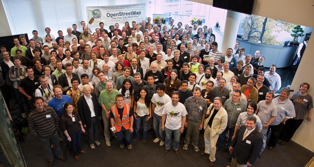
Here are some of the OpenStreetMap contributors, last summer at State
of the Map, in Amsterdam. There were something like 130,000
registered users of OSM at that time, and 250 attended SotM if I
remember correctly.

Look at those shiny happy faces. Like cherubs, every one of ’em.

And how we’ve grown, since then, the OpenStreetMap community. Today
will be the day. The 250,000th contributor will register for an
account at http://www.openstreetmap.org/user/new I feel comfortable
predicting this because OSM gets hundreds of new registrations a day,
and we’re only 45 short of the Big Quarter-Mill. Sometime before
midnight UTC, number 250,000 will register. It might have happened
already.

There is a prize for 250,000

You get the right to a copy of the OSM data set under the OSM data
license. Congratulations, number 250,000. That’s the same prize we
all get. The prize we make by hand and give to each other. Collect
your prize at http://planet.openstreetmap.org/

http://www.openstreetmap.org/stats/data_stats.html
Mon Apr 19 00:00:07 +0100 2010
Number of users
249955

Sure. It’s an arbitrary milestone. Not every registrant contributes
a lot of data. One more contributor might not make much of a
difference. Let’s look at all of us in aggregate. And let’s look at
the next 250,000 to register. How can we, the old-timers, make things
easier on the next group of newbies? We need to make it easier on
them you know. The easier we make it for them, the easier it will be
for us. Otherwise we’re doomed to a spiral of answering the same old
questions at an ever increasing rate.

Go document something for a newcomer to OSM. Write a tutorial. Post
some examples. Help out on the newbies list or #osm. Free some code.
Benchmark osm2pgsql. Squash some bugs on trac. Do it for number
250,000. Do it for the next 250,000.

And take another look at the group photo above. They’re all smiling.
You know what they’re thinking?

OpenStreetMap.
it’s fun. It’s free. I’m helping.

Welcome to OSM, number 250,000. See you at SotM 2010?
http://stateofthemap.org/

SotM 2009 group photo by http://www.flickr.com/photos/mgilbir/
Licensed ccby http://creativecommons.org/licenses/by/2.0/deed.en_CA

Project of the Week: 18 April 2010 – Back to School

Let me take you back to school. Think of all of the wonderful things
about being in school; the fun, the friends, the joy of learning. Now
think of the joy of putting your old school on the map.

The project of the week this week is to put the schools that you
attended on the map. Grade school, high school, post-secondary
schools, put them all on the map. Draw in the building outlines if
they are available, and perhaps the school yard, sport pitches and
play grounds.

Perhaps you aren’t sure that your old school still exists. Was that
building rezoned for a toxic waste dump or condos? Use this project
of the week as an excuse to get in touch with a friend from school who
still lives nearby. Call and ask if it is still a school and if the
name has changed.

Find more details about this Project of the Week.
http://wiki.openstreetmap.org/wiki/Project_of_the_week/2010/Apr_18

This is your Project of the Week. Make suggestions.
http://wiki.openstreetmap.org/wiki/Project_of_the_week/Proposals

New to OpenStreetMap? Join the mailing list for new OSM mappers.
http://lists.openstreetmap.org/listinfo/newbies

It’s fun. It’s free. You can help.

Classroom photo by Corey Leopold http://www.flickr.com/photos/cleopold73/
is CCBYSA, http://creativecommons.org/licenses/by/2.0/deed.en

Image of the Week: Promenade Gardens

Media_httpwikiopenstr_jcqou

Paths between the flower beds and trees in the Promenade Gardens of
Georgetown Guyana.

About Image of the Week
These are Featured images, which have been identified as the best
examples of OpenStreetMap mapping, or as useful illustrations of the
OpenStreetMap project.

If you know another image of similar quality, you can nominate it on
Featured image proposals.
http://wiki.openstreetmap.org/wiki/Featured_image_proposals

Project of the Week: 11 April 2010 – “Get Wired!”

We can take for granted the infrastructure that runs our computers.
the infrastructure that allows us to map, to listen to amplified
music, to refrigerate food. This week we take a look at the power
lines that distribute electricity. Map the high tension lines and
supporting towers as available from aerial imagery.

Find more details about this Project of the Week.
( http://wiki.openstreetmap.org/wiki/Project_of_the_week/2010/Apr_11 )

This is your Project of the Week. Make suggestions.
( http://wiki.openstreetmap.org/wiki/Project_of_the_week/Proposals )

New to OpenStreetMap? Join the mailing list for new OSM mappers.
( http://lists.openstreetmap.org/listinfo/newbies )

It’s fun. It’s free. You can help.

Credits
Power pylon photo is by “TheAlieness GiselaGiardino²³”
( http://www.flickr.com/photos/gi/ ) and is licensed cc-by-sa
( http://creativecommons.org/licenses/by-sa/2.0/ )