Author Archives: Richard Weait

Image of the Week: OSM Helsinki by NIght

Media_httpiimgurcoml2_dcbec

About this Image of the Week
The Hike & Bike Map
(http://wiki.openstreetmap.org/wiki/Hike_%26_Bike_Map) with “By Night”
overlay showing Helsinki, Finland.
Details: http://wiki.openstreetmap.org/wiki/File:OSM_By_Night_Helsinki_2010-03-12.png

About Image of the Week
These are Featured images, which have been identified as the best
examples of OpenStreetMap mapping, or as useful illustrations of the
OpenStreetMap project.

If you know another image of similar quality, you can nominate it on
Featured image proposals.
(http://wiki.openstreetmap.org/wiki/Featured_image_proposals)

Project of the Week – 04 April 2010 – Play Ball!

This week marks the beginning of the 2010 Major League Baseball season
in the USA.[1] Let’s get out and map the major league parks and their
surroundings. Get the ball park to be sure, but let’s also make sure
that the points of interest to a visiting ball fan are mapped as well.
That means restaurants and bars, fast food and public parking lots,
souvenir shops and pharmacies (for sunscreen and bug spray). Street
addresses very much appreciated.

Read more about this Project of the Week, how you can participate and
some examples.
http://wiki.openstreetmap.org/wiki/Project_of_the_week/2010/Apr_04

Rogers Centre photo is cc-by Mike Babcock on Flickr
(http://www.flickr.com/photos/mikebabcock/)

And a call for participation!

Do you have a mapping story that you would like to share? Do you have
a mapping project that could use some help? Are you starting to think
that my PotW postings are a little too, um, similar? You can help by
contributing a PotW.
http://wiki.openstreetmap.org/wiki/Project_of_the_week/Proposals

Bravo, OSM Haiti editors. You saved lives.

From Where 2.0, Jeffrey Johnson (Open Solutions Group), John Crowley
(STAR-TIDES) and Schuyler Erle (SimpleGeo), “Haiti: CrisisMapping the
Earthquake”

[blip.tv http://blip.tv/play/AYHS2l4C]

At the end, hundreds of OSM editors get a round of applause for
contributing to editing Haiti. And saving lives.

Map Kibera project featured on Flickr Blog

Media_httpfarm5static_zxhfg

The Map Kibera project (http://www.mapkibera.org/) is putting Kibera
on the map.

Kibera in Nairobi, Kenya, widely known as Africa’s largest slum, remains a blank spot on the map. Without basic knowledge of the geography and resources of Kibera it is impossible to have an informed discussion on how to improve the lives of residents.

Flickr is able to use the map created by Map Kibera and OpenStreetMap
(http://openstreetmap.org) for placing Flickr geotagged photos.
(http://www.flickr.com/map?&fLat=-1.3126&fLon=36.7937&zl=1)

See the Flickr Blog entry here
(http://blog.flickr.net/en/2010/03/31/map-kibera-project-on-flickr/)
and keep up with the Map Kibera (http://www.mapkibera.org/blog/) and
right here on OpenGeoData.

Nestoria Hiring OpenStreetMap expert(s)

Media_httpsuknestoria_sajrb

Nestoria was an early adopter of OpenStreetMap and has sponsored every
State of the Map conference to date. Now they are interested in
hiring some OpenStreetMap talent.

From the @nestoria account Twitter

Media_httpimgurcomt94_ashbq

“Want a job where you get to build things with #openstreetmap ? We’re
hiring, join us: http://www.lokku.com/jobs/

This could be your big break into the world of commercially-backed OSM
contributors. Give them a ring.

From their Job posting on lokku.com

What positions are available?
We’re currently recruiting for:

* Engineering Manager (permanent)
* Technical Product Manager (permanent)
* Engineering Intern (3-6 months)

All positions will, unless stated otherwise, be based in our central
London office (in Clerkenwell).

Project of the Week 2010Mar28 – Swimming in data

Many of the coastlines in OSM came from an import of the PGS coastline
data. It was a fantastic benefit to be able to add this coastline
data to OSM, and we’re better off having had it. And there are many
places that have aerial imagery that is now good enough to improve on
PGS coastlines. So that is the project of the week for 28 March,
2010, check your favorite bit of coastline and improve what you can
with overhead imagery.

Those without a favorite bit of unimproved coastline might take a look
at the crenelated coasts of North America for examples of what can be
improved. This
http://www.openstreetmap.org/edit?lat=41.044&lon=-72.1591&zoom=14 is a
portion of Long Island with aged PGS coastline that fails to meet our
current standards for Good Coastiness. Sure, it will be fixed up by
the time the second reader gets to it, but have a look at that area in
the original bulk import form,
http://www.openstreetmap.org/browse/changeset/693806 . Okay, perhaps
we can make our current imports a little friendlier to view.

And now a sea change

Let’s improve the Project of the Week while we’re improving the map.
Let’s increase participation. If you are participating in potw,
consider posting some of your before and after shots of the areas you
are mapping. Reply with your comments and links to your good work.
Consider adding “potw” to your changesets. It’s nice to know if you
find a project of the week interesting.

Propose a Project of the Week.

Write it up and add it to the Proposals page, or email me directly.
http://wiki.openstreetmap.org/wiki/Project_of_the_week/Proposals
Make general or specific suggestions regarding potw on the discussion page.
http://wiki.openstreetmap.org/wiki/Talk:Project_of_the_week/Proposals

Share your project!

Detailed, written potw proposals are very warmly welcomed. Tell us
what you are doing, show us how it is making a difference, and let us
know how we can help you with your project locally, or by replicating
it in our neighborhood. Give some example tags and guidelines if you
can.

The massively successful Image of the Week project has been running
since 2006, and is now a flipbook history of What Was New In OSM.
Plus a couple of entertaining April Fool images. Part of the strength
of the IotW is the indefatigable leadership of User:Ojw who has kept
it running for five years. Much of the strength of IotW comes from the
community interest. Folks do something interesting, make an image,
and share it with IotW.

Let’s see if we can make potw at least half as interesting and
informative as IotW. Join in, won’t you?

If you haven’t seen IotW (What? Is that possible?!?!) You must see it
now. Prepare to spend an hour learning the visual history of OSM.
http://wiki.openstreetmap.org/wiki/Featured_images

The Beautiful fish on the reef photo is cc-by Alain76 on Flickr.
The Crashing waves photo is cc-by Wonderlane on Flickr.

SotM 2010 – Call for Papers – OPEN

Media_httpweaitcomfil_quipo

Do you have something to say to an audience of mappers, hackers and
community activists who have revolutionised the way maps are made and
used?Yes? Then this is your opportunity to speak at The State of the
Map 2010 – the largest gathering of OpenStreetMappers in the world –
attracting hundreds of members of the OpenStreetMap community from
around the world to three days of talks, workshops and discussions.
Previous speakers at State of the Map conferences have included:

* OpenStreetMap founder Steve Coast talking about all things OSM
* Humanitarian mapper, Mikel Maron, talking about mapping Palestine
* German community leader Frederik Ramm talking about German map development
* Stamen Design founder Mike Migurski talking about paper mapping
with OpenStreetMap.
* University College London senior lecturer Muki Haklay talking
about OpenStreetMap data quality

And many, many more great talks like these.This year the State of the
Map is inviting talks, posters and workshops on the following
themes:Mapping for the massesOpenStreetMap has come a long way in the
last 5 years. But how can we make sure OpenStreetMap continues to
grow and thrive for the next 5 years? “Mapping for the Masses”
invites speakers to present about their thoughts, opinions, projects
or tools that will help OpenStreetMap grow and help its open map
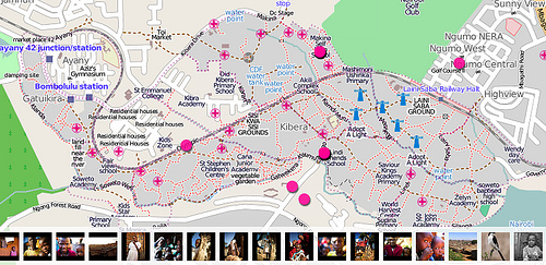
become the richest and most detailed in the world.Living the mapMaps
have long been a source of power, control and wealth in the world.
How is OpenStreetMap’s free map changing the communities that you live
in or work with? What are the social implications of a free and open
map in different countries around the world? How can OpenStreetMap
help make the world a better place.OSM TechtalkOpenStreetMap has a
vibrant community of hackers, systems administrators and app
developers whose work keeps OpenStreetMap going and growing. Maybe
you are working on a new OpenStreetMap editor, plugin, renderer, API
or application that you’d like to share with everyone. If you hang
out on OSM-Dev, dream in bash syntax and know OpenStreetMap’s API
structure off by heart, this is the place for you to share your
knowledge and ideas.

Powered by OpenStreetMap

In the last 12 months, OpenStreetMap powered apps have appeared in app
stores and on the web like never before. More organisations from
governments to universities, NGOs, navigation providers and web
portals are using OpenStreetMap than every before. This session
invites any users of OpenStreetMap to share their experiences creating
OpenStreetMap powered applications and services.
Open Floor

OpenStreetMap moves at a very fast pace. If you are working on a
project or have any idea that doesn’t fit into the themes above, we
still want to hear from you.Who Attends State of the Map?Last year’s
State of the Map attracted 300 attendees for three days of talks and
workshops from organisations and companies including:

* OpenStreetMap mappers, developers and organisers from around the world
* Open source developers: OpenStreetMap, JOSM, Mapnik, OpenLayers, Ubuntu
* Universities and academic institutions around the world:
University College London, MIT, Stanford, Cambridge
* Designers and cartographers: Stamen Design, OpenCycleMap
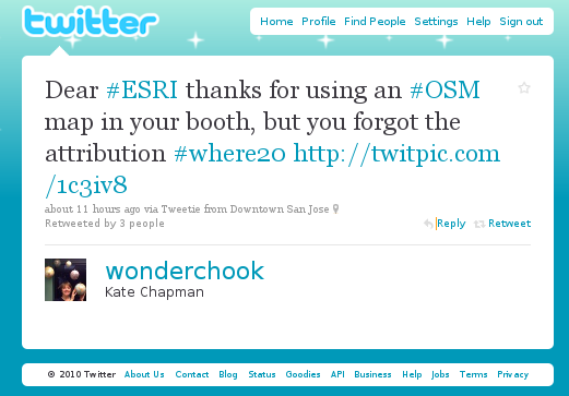
* GIS Industry professionals: FortiusOne, ESRI, Carmenta, Cartotype
* Web Portals: GeoCommons, Yahoo, Google, Bing, Nestoria
* Navigation and LBS: TomTom, TeleAtlas, Nutiteq, skobbler,
Navteq, CloudMade
* OEMs: U-Blox, Nokia
* NGOs: MapAction, UNHCR
* Governments: Surrey Heath Borough Council, Amsterdam City Council
* Heritage: Rijksdienst voor het Cultureel Erfgoed, Oxford Archaeology

Sign Up to Give a Talk, Poster or Workshop
http://stateofthemap.org/call-for-papers/

Do you have something to talk about at The State of the Map 2010?
http://stateofthemap.org/call-for-papers/

This year’s conference will be held in Girona, Spain from the 9th – 11th July.
info@stateofthemap.org
Press Contact: press@stateofthemap.org

Project of the week of March 21, 2010 — Retail therapy

Retail shops and services on Main Street

Few things demonstrate the character of a small town like the shops on
the main street. Even as smaller towns suffer from urban sprawl,
big-boxification and online shopping, some Main Streets survive and
even thrive. Let’s make sure that those Mom ‘n Pop operations, the
general stores and the barber shops that serve as the cultural hub of
their community have the benefit of being on the map. The project of
the week for Mar 21, 2010 is to map a block or more of retail shops.

Retail therapy

Map the shops and services on your favorite Main Street. Substitute a
shopping plaza or mall should you not have a Main Street at your
disposal. We’re looking here for places that hang a sign with their
operating hours and who expect folks to come walking in the door with
a head full of dreams and a pocketful of money, and walk back out with
a product. (Okay, services too.)

Add the cafe, the burger joint, the barbershop, the lawyer, the
library, bank, general store, movie theatre and post office, … all
those places on Main, between Pine and Maple.

Find more details on the Project of the Week page:
http://wiki.openstreetmap.org/wiki/Project_of_the_week/2010/Mar_21

Photo credit, ccby kevindooley on Flickr
http://www.flickr.com/photos/pagedooley/