Author Archives: Richard Weait

Project of the Week: Department Store

A department store sells a wide variety of durable goods for the home.
Large and small appliances, furniture and kitchenware may each have
large sections or departments of the store. Clothing
departments may be further divided by customer and use, such as Infant
and Toddler or Outdoor clothing. The departments will continue,
perhaps with jewelry and cosmetics or sporting goods.

The Project of the Week is to add local Department Stores to the map.

This is your Project of the Week. Make suggestions. Inspire other
mappers. What is it about contributing to OpenStreetMap that
interests you? Postboxes? Bowing alleys? Share your OpenStreetMap interests by contributing a Project of the Week.

Department store exterior photo by Aaron is
licensed CC-By.

Image of the Week: Tube Time Travel

Media_httpwikiopenstr_eovcf

Tom Carden’s Travel Time Tube Map creates isochronic maps of the London Underground.

This is a Featured image, which means that it has been identified as
one of the best examples of OpenStreetMap mapping, or that it provides
a useful illustration related to the OpenStreetMap project.

If you know another image of similar quality, you can nominate it at

http://wiki.openstreetmap.org/wiki/Featured_image_proposals

Project of the Week: instrument shop

What I really need, right now, is an ukulele. I could order one,
overnight from the on-line ukulele store, but I need it now, and
prefer to shop locally. Let’s just have a quick look at the map.

What’s that you say? Steve’s Ukulele Kwikee Mart, is right round the
corner? How convenient.

The Project of the Week is to add your local musical instrument shop.

This is your Project of the Week. Make suggestions. Inspire other
mappers. What is it about contributing to OpenStreetMap that
interests you? Postboxes? Bowing alleys? Share your OpenStreetMap interests by contributing a Project of the Week.

Guitar Lineup photo by Orin Zebest is
licensed CC-By

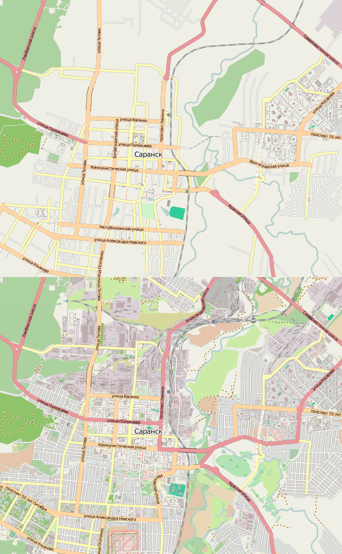
Image of the Week: Saransk Mapping Party

Media_httpwikiopenstr_fxhpa

OpenStreetMap contributor osmisto has
organized the first Russian online mapping party: it’s still cold
outside, so almost everyone attended. Find out more and see a larger animation from the Саранск (Saransk) mapping party.

This is a Featured image, which means that it has been identified as
one of the best examples of OpenStreetMap mapping, or that it provides
a useful illustration of the OpenStreetMap project.

If you know another image of similar quality, you can nominate it on
Featured image proposals.

http://wiki.openstreetmap.org/wiki/Featured_image_proposals

Project of the Week: Music Shop

They aren’t as common as they used to be, or perhaps they have merely
changed form. Some of us have a music store on our phones. Others
might have to travel to the next town to find a Bricks and
Mortar music shop. The used to be called Record Stores;
ask your grand-parents about them.

The Project of the Week is to add your local music shop to the map.

This is your Project of the Week. Make suggestions. Inspire other
mappers. What is it about contributing to OpenStreetMap that
interests you? Postboxes? Bowing alleys? Share your OpenStreetMap interests by contributing a Project of the Week.

Photo of phonograph cylinder player by Jalal Gerald Aro
is licensed CC-By-SA

Working Group Summary

These summaries do not replace the formal minutes of the working groups, they are intended to be a quick and easy summary of recent topics before the working groups.

Communication Working Group

31 January 2011 – The CWG continued minor improvements to the OSMF blog web site. SotM was announced for Denver. CWG seeks OSM contributors who would like to translate materials for the OSMF web site.

Scheduled CWG meetings on 14 and 28 February 2011 were canceled due to scheduling conflicts.

License Working Group

01 February 2011 – Mike and Diane from Creative Commons joined the call and learned more about the OSM license upgrade to ODbL. Reviewed draft of CT v1.2.4 and started translation for international versions. An informal poll regarding per-changeset re-licensing was created. AND indicated their support for ODbL. Initiated contact with several web sites, etc. using OSM without the required attribution. Refer to Creative Commons community for guidance re OSM map in TV program.

08 February 2011 – LWG notes guidance from the board that waiting two or more years for Creative Commons to publish an acceptable data license is not in the best interests of OSM. Minimal response to the per-changeset re-licensing poll; 2 for; 2 indifferent. Translations of CT v1.2.4 are pending. Continued to pursue other attribution issues with contacts at several sites. No response from Creative Commons Community on CCBySA materials within TV shows or ads.

15 February 2011 – French translation of CT v1.2.4 in progress, information regarding the Italian translation is pending. Only five respondents to the per-changeset re-licensing poll; three for; two indifferent. LWG will not recommend creating tools to help manage this data. DWG has offered to help the individuals who wish to remove their questionable data and accept CT/ODbL. Extended poll to talk-gb for additional feedback. Geocaching.com has OSM options on their beta site and have improved their attribution, though a few lingering typos remain. SimpleGeo.com use OSM on a beta site. Attribution was corrected after contacting them. Still no reply for Ben Last / Nearmap regarding discussion in January. LWG decided against permitting revocation of CT acceptance.

22 February 2011 – French translation still in progress, information regarding the Italian translation is still pending. Coding for CT v1.2.4 is complete and pending review. CloudMade aware of their clients with attribution deficiencies; their tools ship with attribution on by default. GeoCaching.com aware of typos and fixing asap. SimpleGeo.com missed attribution on their live site as well and fixed it when notified. A new attribution / license deficiency came to the attention of LWG. CapeTownBicycleMap.co.za “didn’t use OSM but did look at colours for inspiration.”

01 March 2011 – adding decline button to CT page is in progress. CT v1.2.4 is live on http://www.osmfoundation.org/wiki/License/Contributor_Terms and pending on OSM.org. Other attribution deficiencies are in progress. Report of an iPhone app with correct attribution that was later removed.

Strategic Working Group

04 February 2011 – Further review of budgeting process; could be simpler. Review and revisions to tile policy and scorecard. Routing services scorecard and policy to follow.

11 February 2011 – Draft budget work flow document to be simplified further. Review tile policy and score card. Recommended the draft tile policy and score card to board for acceptance. Review of wikimapia use for discussion next week. First review of routing score card and policy.

18 February 2011 – Review simplified budget documents. To be referred to board for acceptance. Feedback from board on tile policy, “Clarify preference for non-commercial tiles.”

25 February 2011 – Budget recommendation forwarded to the board. Clarified “non-commercial” section of tile policy. Tile policy to be returned to the board for acceptance. Discussed Wikimapia and referred to the board without comment. Mikel to miss upcoming meetings due to travel; Henk to chair in the absence of Mikel. The SWG notes the withdrawal of Milo van der Linden from SWG and thanks him for his contributions.

04 March 2011 – Chaired by Henk Hoff. Steven to revise budget docs based on board feedback and discuss next week. Response on revised tile policy pending. Wikimapia was referred to board. Discussion routing services, particularly the merits of public facing routing service vs quality tool for mappers. Discussion to continue on mailing list and next week.

Project of the Week: Stationery shops

Would you pass me the quill and inkpot please?

A stationery shop may seem outdated in a paperless, electronically
connected world. There is something more formal about getting a card
or letter in the mail, something joyful in the anticipation of opening
an envelope, thick with greetings and dreams, from an old friend.
Let’s put the local stationery shop on the map.

What goes into a well-mapped stationery shop? Find out on the Project of the Week: Stationery shop page.

This is your Project of the Week. Make suggestions. Inspire other
mappers. What is it about contributing to OpenStreetMap that
interests you? Postboxes? Bowing alleys? Share your OpenStreetMap
interests by suggesting a Project of the Week.

The current Project of the Month: Bridge and Tunnel continues until the end of March.

Stationery photo by Simon Pearson is
licensed CC-By-ND.

Scientific American: Mapping the food desert

Scientific American has just published an article Amateur Cartographers Map Local ‘Food Desert’ by Francie Diep on urban
food quality.

A volunteer effort to map all the food stores in Brooklyn,
New York, is an example of two rising trends: citizen mapping and
increasing scrutiny of urban Americans’ access to healthy
food

Brooklyn Food Coalition are using OpenStreetMap to present their data
on the web.

Media_httpiimgurcomz6_hahjv

Deli photo by Catherine is licensed
CC-By.

Image of the Week: OpenSeaMap and weather

Media_httpwikiopenstr_wtkrs

OpenSeaMap showing weather information for a storm in the North
Atlantic ocean on 14 February 2011

OpenSeaMap web site

This is a Featured image, which means that it has been identified as
one of the best examples of OpenStreetMap mapping, or that it provides
a useful illustration related to the OpenStreetMap project.

If you know another image of similar quality, you can nominate it at

http://wiki.openstreetmap.org/wiki/Featured_image_proposals

Project of the Month: Bridges and tunnels

Bridges and tunnels assist travel. They span barriers that otherwise
impede travel such as mountains and ravines. They also reduce the
interaction between travelers in cases such as grade-separated railway
crossings, and motorway interchanges.

The Project of the Month is to add local bridges and tunnels to the map.

See the bridge and tunnel project page for more details and results.

This is the a Project of the Month. Project of the Week returns
next week, while PotM will continue until the end of March. These projects
inspire mappers to contribute data they might not have considered
previously, and allow us to be inspired by the projects of other
mappers.

This is your Project of the Month. Make suggestions. Inspire other
mappers. What is it about contributing to OpenStreetMap that
interests you? Postboxes? Bowing alleys? Share your OpenStreetMap
interests with other mappers by contributing a Project of the Month.

Photo of Millau viaduct by Philiip Capper is
licensed CC-By.