Author Archives: Richard Weait

Image of the Week: Saransk Mapping Party Video

[youtube http://www.youtube.com/watch?v=MnNyM41ZcYk?wmode=transparent]

We first told you about the Saransk Mapping Party last month when OpenStreetMap contributors showed us
an animation of the mapping event. A month later, they have created a
video that combines animation of the mapping party with various
renderings for various uses and photos of the ground truth. Enjoy the
video.

This is a Featured image, which means that it has been identified as
one of the best examples of OpenStreetMap mapping, or that it provides
a useful illustration related to the OpenStreetMap project.

If you know another image of similar quality, you can nominate it at

http://wiki.openstreetmap.org/wiki/Featured_image_proposals

OpenStreetMap on Television

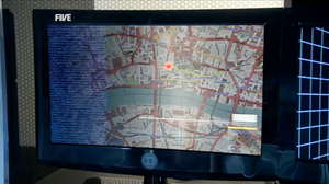
London OpenStreetMap in K9 episode The Bounty Hunter

[Updated 20 May 2011]

Above is an image of London, from the OpenStreetMap Mapnik rendering style, as it appeared in an episode of K9. K9 is a television series for 11 to 15 year-old children, produced by Stewart & Wall Entertainment.

As OpenStreetMap contributors, we enjoy seeing our collective map used by others. The nice folks at Stewart & Wall Entertainment wanted to do more for OpenStreetMap than just use the map in their TV program. They have also written a nice note on their web site, thanking us all for providing a cool map. You should read the note in their news section because it suggests something very cool for the future. And they have added a credit on the series information page, too.

Thanks, Stewart & Wall!

[ 20 May 2011 update ]

Stewart & Wall have added a “thanks” to OpenStreetMap on the company credits page for The Bounty Hunter on IMDB.

Geocaching beta map includes OpenStreetMap

It’s nice to see interesting projects using OpenStreetMap for
interesting things. Geocaching.com have a Beta map that allows
users to select OpenStreetMap mapnik tiles as one of many basemaps.
This is pretty cool. What’s even cooler is that we may be approaching
the point where OpenStreetMap and Geocaching start to make each other
noticeably better.

Geocaching and OpenStreetMap seem like a match made in a top of the
line GPSr. As a long time OpenStreetMap participant, it has always
seemed like a natural match. It seemed to me that Geocachers would
like OpenStreetMap. Why did it take me so long to try geocaching?
And what secret did I learn that Geocachers will want to know?

Learn the secret about OpenStreetMap that your Geocaching friends will want to know.

Project of the Week: Groceries

Food month continues. The Project of the Month is farmers’ markets
where you can buy fresh food ingredients directly from the farmer.
This week we look at grocery stores, where we can get fresh food
ingredients but they might be from further away and from many vendors.

This week we look at fresh fruit and vegetables from shops large and
small. For smaller shops we have greengrocers, for larger we have
supermarkets.

For project of the Week add your local grocery stores to the map.

This is your Project of the Week. Make suggestions. Inspire other
mappers. What is it about contributing to OpenStreetMap that
interests you? Postboxes? Bowing alleys? Share your OpenStreetMap
interests by suggesting a Project of the Week or Project of the Month.

Greengrocer photo by artq55 is licensed CC-By-SA.

Potlatch 2 is here

OpenStreetMap editing just got faster, smarter and smoother! We’ve
done the switch-over to Potlatch version 2 on the ‘edit’ tab of
the OpenStreetMap homepage.
If you haven’t tried it already, click that ‘edit’ tab and get
mapping!

This represents a lot of development work by Richard Fairhurst, Andy Allan, randomjunk,
and others. The work really picked up pace recently, with everyone
pulling together, but Potlatch 2 has been in the pipeline for a couple
of years now. It doesn’t stop there of course, but it’s ready for
prime-time now, so we’ve made the switch. We hope you like it, but for
now you can still get back to the old potlatch by hovering your mouse
over the edit tab.

So what’s new in Potlatch 2?

  • User-friendly tagging with customisable presets
  • WYSIWYG rendering
  • Vector Background Layers
  • A more flexible undo/redo system
  • OAuth support so you can deploy it on other websites

Keyboard shortcuts and other aspects of general editing have largely
stayed the same

We’ll be working to update documentation and hopefully create some
nice new video tutorials etc (and anyone can help with these things)
but for now you can find out more on the Potlatch 2 wiki page and the Potlatch 2/Primer

Project of the Month: Marketplace – Food Month

Where do you go for a really delicious tomato? To your garden, of
course, but between seasons you might be limited to tomatoes shipped
well before they are ripe, from another country, or another
hemisphere. Unless you know about a farmers’ market or a roadside
stand where you can get a local hot house tomato.

Local food and food supply have been in the press recently. This
month, we look at various aspects of the food supply chain.

We map marketplaces and farmers’ markets for the Project of the Month of April 2011

This is your Project of the Month. Make suggestions. Inspire other
mappers. What is it about contributing to OpenStreetMap that
interests you? Postboxes? Bowing alleys? Share your OpenStreetMap
interests by suggesting a Project of the Week or Project of the Month.

The current Project of the Month: Bridge and Tunnel continues until the end of March.

Marketplace photo by Chas Redmond is
licensed CC-By