Author Archives: Richard Weait

Tile server upgrade

The OpenStreetMap server team has upgraded the tile server to render changes faster. Demand for OpenStreetMap tiles has increased steadily as the project grows. Recent increases in demand for tiles has lead to long waiting times for mappers who want to see the results of their improvements to the map.

Thanks go to Grant Slater, Jon Burgess, the Mapnik.org team, and many others who keep improving OpenStreetMap every day in ways large and small.

Read the announcement and hardware details on talk@.

Speedometer photo by Nathan E Photography is licensed CC-By

New Changeset display

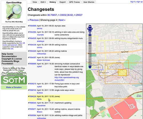
The OpenStreetMap web site was updated today. When you view the history tab, you’ll now see a map with bounding boxes shown for recent changesets in the area. Hovering over the changeset will highlight the bounding box, and vice-versa.

This improvement was coded by Mikel and refined by Mikel and TomH.

Read more about this from Mikel’s announcement on his blog.

Project of the Week: Gyms and Dojos

May is sport and activity month. We’ll be adding various sport and
activity locations to the map. The Project of the Month: Sport fields continues through May. Each Project of
the Week during May will focus on another type of sport or activity
facility.

Gyms and Dojos

Gyms and dojos are similar in structure and purpose. Both tend to
include an open activity area for classes and exercise stations with
exercise equipment and free weights for strength and flexibility
training. While the activities and locations are very similar, a dojo
may distinguish itself with a focus on a particular martial art, or
group of martial arts.
The Project of the Week is to add local gyms and dojos to the map.

This is your Project of the Month. Make suggestions. Inspire other
mappers. What is it about contributing to OpenStreetMap that
interests you? Postboxes? Bowing alleys? Share your OpenStreetMap
interests by suggesting a Project of the Week or Project of the Month.

Gym photo by Neeta Lind is licensed CC-By

OpenStreetMap tile layer guidelines

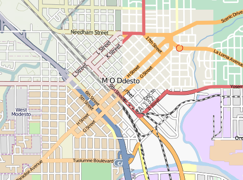
mosaic of Modesto California, shown in four different tile styles.

Mosaic of Modesto, California, in four tile layer styles.

The image above was inspired, in part, by Firefishy’s April Fools Day joke, OpenWhateverMap. While such a map is unlikely to be used for an ordinary application, it does serve to show the wide variety of renderings of OpenStreetMap data that are created by the OpenStreetMap community and displayed on the OpenStreetMap web site. It also serves as an illustration of one of the frequently asked questions about the OpenStreetMap.org web site.

How are maps added to the OpenStreetMap web site?

Until December 2005, the OpenStreetMap web site did not have a map shown at all.
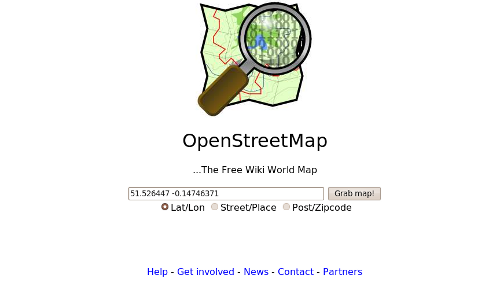
The OpenStreetMap main page in November 2005 had no map. (Courtesy Internet Archive)

Starting in December 2005, maps have appeared on the OpenStreetMap web site. Today, the slippy map is the most prominent feature of the OpenStreetMap web page. Currently there are four rendering layers that can selected on the front page as well as one overlay layer.

The OpenStreetMap Foundation now has published guidelines for tile layers to be considered for inclusion on the OpenStreetMap web page. If you know of an interesting rendering of OSM data, and you think it should be considered as a Featured Layer, add your suggestion to the featured tiles score card and start the discussion.

The proposed layers will be evaluated for suitability by the Technical Working Group, periodically, and the tile layer that you recommend could be featured on the OpenStreetMap web site.

Project of the Month: Sport and activity month

May is sport and activity month at Project of the Week.

The joyous sounds of children playing. The roar of the crowd at a
well executed play. The Project of the Month is to map your local sport fields. Put
your local sport fields on the map.

This is your Project of the Month. Make suggestions. Inspire other
mappers. What is it about contributing to OpenStreetMap that
interests you? Postboxes? Bowing alleys? Share your OpenStreetMap
interests by suggesting a Project of the Week or Project of the Month.

Image of the Week: OpenWhateverMap

Media_httpwikiopenstr_hqwkp

OpenStreetMap contributor, Firefishy, created OpenWhateverMap.org to
demonstrate a variety of map themes all at the same time.

OpenWhateverMap was launched on 01 April 2011.

This is a Featured image, which means that it has been identified as
one of the best examples of OpenStreetMap mapping, or that it provides
a useful illustration of the OpenStreetMap project.

If you know another image of similar quality, you can nominate it on
Featured image proposals.

http://wiki.openstreetmap.org/wiki/Featured_image_proposals

OpenStreetMap recognized by UN Foundation

Media_httpiimgurcomba_nnufs

The United Nations Foundation, the United Nations Office for the
Coordination of Humanitarian Affairs and others have recognized the
crucial role played by OpenStreetMap in relief efforts in Haiti and
elsewhere.

Quoting from the UN Foundation Disaster Relief 2.0 Fast Facts

OpenStreetMap (OSM) is a community of approximately
150,000 mappers dedicated to building a free and open map of the
world. OSM mobilized more than 640 volunteers around the world, who
scanned and rectified old atlases and maps and traced Haitian roads,
bridges, and buildings into the OpenStreetMap geospatial wiki using
tools that only required a simple web browser and time. In the
process, this community turned a blank spot on the map into one of the
most accurately mapped countries in the world—creating a map far
better than any available to the UN. By mid-March, OpenStreetMap had
become the de facto source for Haiti map data within most UN agencies
and the EC Humanitarian Unit. MapAction credits OpenStreetMap with
providing an essential service and for building a street map of Haiti
from scratch in about two weeks, a project that should have taken
about a year.

Project of the Week: Food Month – Delicatessen and Convenience Stores.

April is food month. We’ll be tagging various portions of the food
supply system in and around our homes. We’ll look at Farmers’ Markets
for the full month; venues for many vendors of food directly from the
source. Through the month we’ll look at individual vendors of various
foods. As always, Project of the Week and Project of the Month exist
only to encourage your mapping. You don’t need to wait for a project
to add a cheese shop to the map! Unless, of course, you waited for
this week! This week, prepared foods.

Delicatessen, convenience stores and prepared food

Prepared foods occupy that middle ground between groceries and a
restaurant. Some delicatessens have seating and table service, and
might be correctly tagged as {{tag|amenity|restaurant}}. But the
stock in trade of the deli is prepared food. Cured meat, or potato
salad, or caviar, or herbed olive oil for inclusion in your family
meals. The convenience store might provide you with a pre-made
sandwich and a carton of milk, but table service is unlikely. So is a
chair. Recent studies have found that urban areas with financial
challenges often lack the markets and grocery stores from earlier in
this project of the month.

This week we look at those not-quite-restaurants that are not quite
food vendors. The prepared food vendors such as delis and convenience
stores are the focus of this Project of the Week. Let’s put our local delis and convenience stores and other prepared food vendors on the map.

This is your Project of the Month. Make suggestions. Inspire other
mappers. What is it about contributing to OpenStreetMap that
interests you? Postboxes? Bowing alleys? Share your OpenStreetMap
interests by suggesting a Project of the Week or Project of the Month.

Deli photo by Liz Henry is licensed CC-By-ND

Image of the Week: OpenStreetMap in flight simulator

Media_httpwikiopenstr_cbejx

OpenStreetMap data is used to generate 3-D terrain data for a flight
simulator. In the photo above, terrain for the X-Plane filght
simulator is generated by a program called osm3xp.

This is a Featured image, which means that it has been identified as
one of the best examples of OpenStreetMap mapping, or that it provides
a useful illustration of the OpenStreetMap project.

If you know another image of similar quality, you can nominate it on
Featured image proposals.

http://wiki.openstreetmap.org/wiki/Featured_image_proposals

Project of the Week: Cheese Shops and more

April is food month for Project of the Week / Month. We’ll be tagging
various portions of the food supply system in and around our homes.
We’ll look at marketplaces for the full month; venues for many vendors
where you can buy directly from the source. Through the month we’ll
look at individual vendors of various foods. As always, Project of the
Week and Project of the Month exist only to encourage your mapping.
You don’t need to wait for a project to add a cheese shop to the map!
Unless, of course, you waited for this week! This week, we address the
cheese shop and other specialty food ingredient shops.

This week we look at food vendors who offer specialty ingredients. The
butcher, baker, cheese monger, fish shop, and other specialty food
stores are the focus of this Project of the Week. Let’s put our favourite specialty ingredient vendors on the map.

This is your Project of the Week. Make suggestions. Inspire other
mappers. What is it about contributing to OpenStreetMap that
interests you? Postboxes? Bowing alleys? Share your OpenStreetMap
interests by suggesting a Project of the Week or Project of the Month.

Cheese photo by nikoretro is
licensed CC-By-SA