If reading via RSS, see this post for embedded live streaming player.
Monthly Archives: July 2009
OSM on TV in DE
Finding things to fix
You might be familiar with the nonames layer which highlights roads which don’t have a name, typically because they’ve been drawn in from aerial imagery:
Now to aid you fix up TIGER there is a layer to figure out what needs checking. See what this looks like in San Francisco:
The red lines are roads imported from TIGER data which have not been edited yet, the green ones have been. The idea here is to find some red lines, click the ‘edit in OSM’ link at the bottom right and then modify the tiger:reviewed tag to be ‘aerial’ if indeed you can check it against aerial imagery.
Next is addressing. This layer shows where there are buildings, points of interest and ranges of address data. See this example in London:
This is really useful to see where we next need to add address data. Notice the patches of addressing most likely centred on key peoples houses. OSM started this way with roads around key people, and spread in to the fantastic map you see today. Employing the same strategy of exposing where the data is we can quickly fill in the blanks.
Help Jordan Hatcher attend SotM
The author of the ODbL, Jordan Hatcher is looking for support to hit SotM. You can donate today. Read more on his blog post:
I’ve booked my travel and am in the midst of preparing my talk at State of the Map (SOTM) 2009 in Amsterdam.
Throughout co-founding Open Data Commons and drafting the Open Database Licence (ODbL), I’ve spent several hundred hours of attorney time, all donated pro bono. While I’m more than happy to donate more time to come speak at SOTM (including a day off work and about 2 days of prep time), I don’t want to be out of pocket on any of my expenses. Even though the licence may be free as in beer and free as in liberty, it isn’t free to travel from the UK to Amsterdam and stay two nights, especially in high season.
I’ve tried to travel and stay as economically as I can, and so I’m only asking for about 554£ to cover my expenses, which include:
– 159 € for return train travel Reading, UK to Amsterdam
– 280€ for 2 nights hotel
– 32 € for bicycle rental at Damstraat
– 75€ = 25 €/day for incidentals and food while traveling
– 100€ Community Passport registration at SOTM
Total 646€ (about 554£)
All money donated in excess of the costs of travel will go towards the goals of the Open Knowledge Foundation, a non-profit promoting open knowledge: that’s any kind of information – sonnets to statistics, genes to geodata – that can be freely used, reused, and redistributed. OKFN organizes events like OKCon, run projects like Open Shakespeare, and develop tools like CKAN and KnowledgeForge to help people create, find and share open material.
Please go to
http://okfn.org/support/donate/
.. to donate via PayPal and mark your donation “SOTM”
I also would very much like your suggestions on what I should cover in my talk – and if I don’t get a chance to address it feel free to come up and find me!
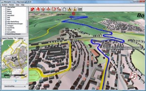
3D Routing Through OpenStreetMap-3D
Users now can plan a route online at OSM-3D.org and then interactively fly along the route presented in 3D. Currently the routing is available for cars (fastest/shortest) as well as for pedestrians or bicycles for all of Germany. It is also possible to create an animation that follows the 3D route automatically. The application is powered by an extended version of OpenRouteService.org and uses the free data from OpenStreetMap.org and the Open Location Services (OpenLS) specifications of the Open Geospatial Consortium (OGC).
Read more here
ODbL 1.0 launched
The Open Database License 1.0 has been launched. Check out OSM’s implementation plan.
The ODC announcement is here:
The Open Database License (ODbL) is an open license for data and databases which includes explicit attribution and share-alike requirements.
This license, the first of its kind, is a major step forward for open data. There are currently very few licenses available suited to data and databases and none which provide for share-alike (existing share-alike licenses such as the GPL, GFDL and CC By-SA are all unsuitable for data).
The development of the ODbL, has been a major effort extending over more than one and half years with an intensive consultation and review period for the last 6 months. We’d like to express our thanks to the communities and individuals who have contributed during this time.
Help me make your map better
I’m trying an experiment with walking-papers. Get all my non-mapping friends to print out a map of their area, write on the print out the errors, house numbers etc and then I will do the rest. I’ve tweeted here:
“Help me make your map better http://bit.ly/B8F5X – what you think?”
You can too. Get your friends, family… even enemies involved. Re-tweet or facebook status update with that, or ask them to send you the paper yourself.
This is a great way to get lots more people involved, and spread your mapping efforts. For bonus points, next time you see your Aunt Ethel print it out for her, or get all your workmates to fix their home areas. Buy a pint for the person with the best map updates.
SOTM now just over 7 days away
Have you registered? Check out State of the Map. And, there are still many cheap travel options with easyJet and others.
Vote Steve
Directions Magazine has opened up a vote for the “Most Influential” in Geospatial for the next 5 years. Others up include Jack and Ed


