Need to sort out lots of bits and pieces today, OSMonth will resume tomorrow at day 6 (eg, this is a pause and not counted as a day). Hope the Yahoo thing is good enough for today!
Author Archives: Steve Coast
Yahoo! aerial imagery in OSM
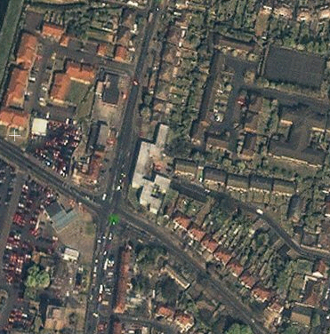
Yes, really. Yahoo! have agreed to let OSM use their aerial imagery. Many thanks are due to Jeremy Kreitler and Scott Regan at Yahoo! for putting this together. On the OSM end, Mikel Maron has put a lot in and I’ve (steve) rewritten the applet tiling code to use Yahoo! Imagery. So what does it look like? Well this is what we could use before, Landsat:

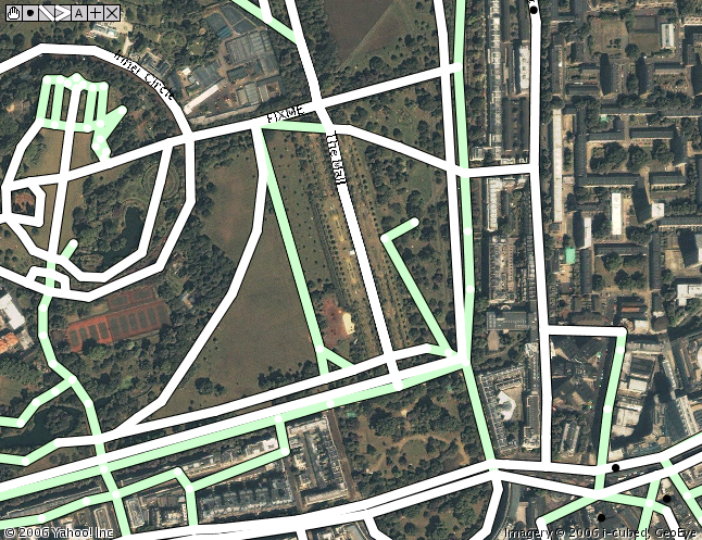
It’s about 15 meter per pixel and so not super useful for things like streets. This is the kind of imagery (actually the same area a bit zoomed in from the above) that Yahoo provides:
Bit better, isn’t it? Yahoo has large sections of the US, 200 world cities (for example the London imagery goes out beyond the M25) and more data being added all the time. Makes that mid 2008 goal a little more real. So what’s the applet look like?
No it’s not a mock up, check out this video:
There’s code in there which updates the relevant image copyrights which we must respect, along of course with Yahoos. This updates depending on what you’re looking at. We can of course derive vectors from it for use in OSM. The code needs some cleanup and tweaks. It needs to be integrated in to the site too, expect it in a week or so.
Of course, we still need to get all those street names and features. GPS traces are by no means dead – think of the new housing estates and areas without imagery. But instead of cycling down every road you should be able to just pass lots of them at either end to get the names. Or just from memory.
Where does this bring us to? Well the ‘big map companies’ use expensive cars and expensive aircraft with expensive cameras and expensive GPS units to create maps. Maybe our GPS units are cheaper and less accurate, but does it matter? I think not. We now have all the pieces of the puzzle and we’re putting out great maps for Free using Free tools.
Thanks again Yahoo!
RGS
![]()
Dr Muki Haklay from the Geomatic Engineering dept of UCL has very kindly organised with the The Royal Geographical Society some funding for further work on OSM.
I’ve known Muki from when I worked at CASA one summer long ago. OSM started as some conversations with his colleague Martin and also Matt. Muki did a great talk at the first asklater nights about map usability (or lack of it) online. Unfortunately the recording broke but I remember him pointing this gmaps query out and the fundamental lack of DPI problem with showing maps on computers.
A few people on the mailing list are graduates of either UCL or the GE department, and it’s great to be supported by the community, a map company and academia.
SIS OSM Support
OSMonth: Day 5
Day 5! This day is brought to you by Steve Clark and Ralf Zimmermann 🙂
Stuff done so far:
- nodes and segments (plural) (bug 308) rails API calls to get multiple nodes/segs
- ways too
- GZip compression on the rails API output
- Got rails daemons working (needed to import gpx files every n minutes)
- bvh on IRC asks what OSM Central command looks like:
- Blogged about the SIS plugin, see next post
- Lots of GPX stuff, it’s almost all there. Missing pages and the tags just get thrown away right now. But, it parses and inserts the data and draws the pictures. The big picture is even animated now.
That’s week 1 gone, we’re 1/4 way through already!
OSMonth: Day 4
Need to figure out who to thank… today it’s Martin Dodge and Matt Amos!
So far:
- Upgraded opengeodata to latest wordpress and activated askimet to kill all the fricking spam
- Ongoing stuff to get Merkaartor speaking 0.4
- Got a basic edit page in place in the rails port and got the view/edit/traces tabs working
- more rails trace stuff
- Found out why way/xxx/history is returning 500 INTERNAL SERVER ERROR. This is a WONTFIX as it’s not that big a deal and I’ll make sure it’s working in the rails port
- Fixed up the rails API to support node/segment/way history calls and fixed a few severe bugs on the way (changeset 1700)
Not sure if there will be an OSMonth day tomorrow as I feel a bit ill. If not then things will restart Sunday or Monday.
OSMonth: Day 3
Still no camera although Amazon Jersey says it’s en route. Todays late-start thanks go to Andy Robinson and Dan Karran
Stuff done today:
- Fixed odd zoom levels in the slippy map (bug 306)
- Fixed a bug where if you just looked at index.html the view, edit, login links etc had crazy lat/lon values
- Created an italian mailing list
- Begun dropping everything from the tiger import that was broken tiger import. Done! Something like 25 or so million segments, nodes and ways gone.
- looked at and converted some potential GPS data (from a currently anonymous source) in to GPX to see if it’s useful (it is)
- Camera arrived, setting it up
- Camera (stevecam) set up, take a look on the sidebar. Should upload every 2 minutes. Brightness issues to be worked out.
- Fixed a bug stopping traces getting imported
- An awful lot of tile work to figure out how to render all the tiles we need to (summary here)
A good day!
OSMonth: Day 2
First things first, figure out who to thank… And thanks go to Richard Fairhurst and Thomas Walraet.
Things done so far:
- UTF8 database output which is fixed in the API but not the planet dump, looking at that. Fixed, see diff.
- tile.openstreetmap.org commissioned, tiles moved over there from dev
- added tile@home and WMS-C to the main page
- If you’re about in London this evening I’ll be at OKFN Forum on Civic Information No. 2
- repaired a (serious) database corruption issue
- UCLs (where openstreetmap is) network went down then came back
- fixed a road in Brockham, Surrey that was missing after the Surrey Hills party
- Looked over tile stuff on the train, went to some interesting talks and got to spend some time with Mikel and Nick Black. Headed back in to train oblivion. Had to cycle back 15km at 12:30am. Yes. Really. Still, more data for OSM!
OSMonth: Day 1
It begins! I’m bored of waiting for the webcam (which amazon thinks will be here tomorrow or the next day) and I want to get on with coding. Today is sponsored by Tom Carden and Nick Black. I’ve been doing a lot of tile stuff lately so I’m going to hack on the rails port of OSM which really needs to get finished. I’m not sure to what extent I’ll be on IRC as it seems to detract a lot from actual work.
Things done today:
- With help from gagravarr fixed a datum error in the Nottingham data
- Got the way API working in the rails port (bug 283)
- Got the map API working in the rails port (bug 288)
- Half of getting GPX upload and import working (bug 287)
A good start, with 9 commits and 2 bugs squished (you can subscribe to the RSS feed for subversion over here).
Summing up DRM
There was an excellent slide pointed at by this bb article the other day from the people who cracked the XBOX. Highlight is this quip:
The worst way to keep a secret is to put it on the shelf at Best Buy