Author Archives: Richard Weait

Project of the Week: Place of worship

Media_httpwikiopenstr_amdiy

A place of worship serves as a meeting place, a place to celebrate or
remember and as a focal point of a community. Some places of worship
are useful in navigation as a distinctive or tall building.

The Project of the Week is to add local places of worship to the map.

http://wiki.openstreetmap.org/wiki/Project_of_the_week/2010/Dec_22

This is your Project of the Week. Make suggestions. Inspire other
mappers. What is it about contributing to OpenStreetMap that interests
you? Postboxes? Bowing alleys? Share your OpenStreetMap interests by
contributing a Project of the Month.

http://wiki.openstreetmap.org/wiki/Project_of_the_week/Proposals

Mosaic of four place of worship images assembled by OSM contributor Ulfl.

Image of the Week: Enhanced OpenStreetMap buildings

Media_httpwikiopenstr_xheab

OpenStreetMap contributor Komяpa has found a way to render 3D
buildings with Mapnik. Famous Ostankino tower (drawn by Hind) looks
very real! It even has a shadow. Discussion in Russian and more
screenshots.

Find out more:

http://forum.openstreetmap.org/viewtopic.php?id=10342

http://wiki.openstreetmap.org/wiki/User:Jongleur/MultiLevel_Building_Shapes

This is a Featured image, which means that it has been identified as
one of the best examples of OpenStreetMap mapping, or that it provides
a useful illustration related to the OpenStreetMap project.

If you know another image of similar quality, you can nominate it at

http://wiki.openstreetmap.org/wiki/Featured_image_proposals

Project of the Week: Bicycle parking

We want to watch our waistlines and our carbon consumption so we like
to ride our bikes more than we used to do. That’s fine when we take a
trip for the sake of a trip, but what about when we want to pick up
the groceries, or borrow a book from the library? We need a safe place
to put our bike so that it won’t impede others and so that it will be
there for us when we need it again. We need a bike rack.

The Project of the Week is to map your local bicycle parking infrastructure.

Learn more about how to add bicycle parking to OpenStreetMap on the wiki.

http://wiki.openstreetmap.org/wiki/Project_of_the_week/2010/Dec_15

This is your Project of the Week. Make suggestions. Inspire other mappers. What is it about contributing to OpenStreetMap that interests you? Postboxes? Bowing alleys? Share your OpenStreetMap interests by contributing a Project of the Month.

http://wiki.openstreetmap.org/wiki/Project_of_the_week/Proposals

Bike Rack photo by Carolyn Tiry http://www.flickr.com/photos/carolyntiry/
is licensed CC-By-SA http://creativecommons.org/licenses/by-sa/2.0/deed.en

Image of the Week: Montreuil-le-Gast Mapping Party

Media_httpwikiopenstr_hlfbu

A great day mapping for residents of Montreuil-le-Gast ([4])
(Brittany, France). The first time for many of us, but ultimately a
great success!

This is a Featured image, which means that it has been identified as
one of the best examples of OpenStreetMap mapping, or that it provides
a useful illustration of the OpenStreetMap project.

If you know another image of similar quality, you can nominate it at

http://wiki.openstreetmap.org/wiki/Featured_image_proposals

Project of the Week: Fire Station

We might not think of them very often. Perhaps a bit of irritation
when we are awakened at night by a siren, or when we pull over to let
emergency vehicles pass. But the fire department provides a vital
service and we are always happy to see them when we need them.

The Project of the Week is to map your local fire station. Learn how to map a fire station for OpenStreetMap on the wiki.

http://wiki.openstreetmap.org/wiki/Project_of_the_week/2010/Dec_08

This is your Project of the Week. Make suggestions. Inspire other
mappers. What is it about contributing to OpenStreetMap that
interests you? Postboxes? Bowing alleys? Share your OpenStreetMap
interests by contributing a Project of the Week.

http://wiki.openstreetmap.org/wiki/Project_of_the_week/Proposals

Fire station photo by James Case http://www.flickr.com/photos/capcase/
is licensed CC-By http://creativecommons.org/licenses/by/2.0/deed.en

Image of the Week: Animation of aerial imagery tracing

Media_httpimgurcom887_lcabf

OSM contributor Findvej sends this animation of an editing session in Denmark.

Just two hours of work in JOSM with the new Bing layer in a location
(Hjerting, Esbjerg, Denmark) with low coverage. All street names have
been added as well, from the updated KMS dataset.

Screenshots were taken about every five minutes and compiled to animated gif.

View the image full size to see the animation.

This is a Featured image, which means that it has been identified as
one of the best examples of OpenStreetMap mapping, or that it provides
a useful illustration of the OpenStreetMap project.

If you know another image of similar quality, you can nominate it at

http://wiki.openstreetmap.org/wiki/Featured_image_proposals

Project of the Week: Railway station

They are a point in a daily commute of countless people. Utilitarian,
they must provide for efficient movement of people in crowds.
Seemingly vacant at one minute and then teeming the next, with the
hustle and bustle of those determined to get from here to there. The
ordinary and repetitious trip of a commuter can lead to blank faces,
seeming drones programmed to catch the 7:15 without interaction with
others, without emotion.

Yet they have also been the scene of emotional hellos and goodbyes. A
backdrop to tears and embraces, an important goal in a departure or a
return.

The Project of the Week is to map your local train station, bus depot,
or other public transit center. Learn more about this Project of the
Week on the OpenStreetMap wiki:

http://wiki.openstreetmap.org/wiki/Project_of_the_week/2010/Dec_01

This is your Project of the Week. Make suggestions. Inspire other
mappers. What is it about contributing to OpenStreetMap that
interests you? Postboxes? Bowing alleys? Share your OpenStreetMap
interests by contributing a Project of the Month.

http://wiki.openstreetmap.org/wiki/Project_of_the_week/Proposals
Goodbye train photo by Till Krech http://www.flickr.com/photos/extranoise/
is licensed CC-By http://creativecommons.org/licenses/by/2.0/deed.en

OpenStreetMap editor Potlatch 2 launched

Media_httpwikiopenstr_fwaej

You may have noticed something new in your OpenStreetMap editing
today. Potlatch 2 has now gone live on OpenStreetMap.org. Potlatch 2
is a complete rewrite in ActionScript 3 using the free Flex 3
compiler. Potlatch 2 rendering uses MapCSS and RichardF’s halcyon
rendering library. It’s new. It’s Open Source. And it’s on
OpenStreetMap.org

But, why didn’t I notice it?

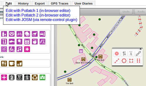
That’s a fair question. You might not have noticed Potlatch 2 on the
main OpenStreetMap.org web site because it is now an editor option.
That’s right. If you hover over the Edit tab, you can select from
Potlatch or Potlatch 2. JOSM is also an option if you have JOSM open
with the remote control plugin active. You can set a default editor
in your API user preferences. [Support for the Merkaartor remote
control plugin is coming soon.]

Media_httpimgurcomerc_fxzgk

Potlatch 2 may not be the right editor for everybody. There will be
bugs discovered, and removed as development continues. Consider
adding Potlatch 2 to your editing arsenal, and be sure to report any
bugs you find.

The amazing team behind Potlatch 2 and this update to the web site
includes some of the same people who keep OSM running and have been
making OpenStreetMap great for years.

Richard Fairhurst http://wiki.openstreetmap.org/wiki/User:Richard
Andy Allan http://wiki.openstreetmap.org/wiki/User:Gravitystorm
Tom Hughes http://wiki.openstreetmap.org/wiki/User:TomH
Dave Stubbs http://wiki.openstreetmap.org/wiki/User:Randomjunk
Matt Amos http://wiki.openstreetmap.org/wiki/User:Matt

And thanks extend to many others including all of those who keep OSM
running day to day, all of the Potlatch 2 testers, documenters, and
MapQuest for sponsoring Andy’s development time over the past few
months.

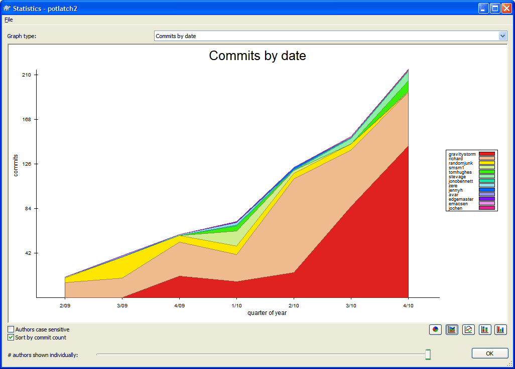
You can see a graphical representation of the development of the
Potlatch 2 code here:

Media_httpwikiopenstr_abcen

Congratulations to the entire Potlatch 2 team and thanks for this new editor!

Developers wishing to contribute to Potlatch 2 will find the code in
svn and can hack on it with the Open Source Flex compiler.

http://svn.openstreetmap.org/applications/editors/potlatch2/README.txt

Open an editing session in Potlatch 2

http://www.openstreetmap.org/edit?editor=potlatch2

Image of the Week: OpenStreetMap data in svg layers

Media_httpimgurcompjc_aimjg

A screenshot of Illustrator showing a SVG file produced by Maperitive.
This new functionality is available in the newest release of
Maperitive.

This is a Featured image, which means that it has been identified as
one of the best examples of OpenStreetMap mapping, or that it provides
a useful illustration of the OpenStreetMap project.

If you know another image of similar quality, you can nominate it at

http://wiki.openstreetmap.org/wiki/Featured_image_proposals