Author Archives: Frederik Ramm

New German Local Chapter FOSSGIS e.V.

We’re excited to welcome our latest local chapter, FOSSGIS e.V. from Germany. FOSSGIS e.V. has been around since 2001; they started out as an association of GRASS users and gradually widened their objectives to include the advancement of all open source and open data in GIS. “FOSSGIS e.V.” stands for Free & Open Source Software Geographic Information Systems (plus “eingetragener Verein” meaning “registered association”)

FOSSGIS e.V. have provided support to the German OpenStreetMap community since 2008. They run the domain openstreetmap.de, handle inquiries from German users of OpenStreetMap, and run a couple of services that are of great use to OSM in Germany and beyond, like a development server or the Overpass API servers. OpenStreetMap is also a major topic at the yearly FOSSGIS conference, usually filling a whole lecture track by itself.

FOSSGIS e.V. run their own micro-grant programme which has been put to various OSM-related uses in the past, like financial support for various kinds of meetups or niche projects (OpenFireMap, historic.place, the German OpenStreetMap podcast, and others).

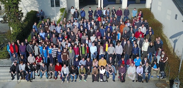
Group photo from the last FOSSGIS conference in Passau, Germany

Unlike most other OSMF local chapters, FOSSGIS e.V. has not been incorporated solely for that purpose. They do other things unrelated to OpenStreetMap, for example supporting projects like QGIS, GRASS, deegree, and their respective communities and meetups, or doing work focused on making Open Source GIS software popular in universities. They are also a local chapter of OSGeo.

We’re looking forward to a prosperous collaboration with FOSSGIS e.V.!

OSM first to honour plate tectonics

Published: 1st April 2017 😋

OpenStreetMap is set to be the first world-wide geo database that actively tracks plate tectonics. The OSM Foundation board has given the green light for tectonic correction to be applied to the OSM database, starting today.

You won’t notice it immediately – the changes are minuscule enough to be laughed at by some. But the effects are undeniable, and our always dedicated sysadmin team has been hard at work to devise queries against our database that correct for plate tectonics.

As you know, the earth’s surface is made of tectonic plates that drift apart slightly over time. With OSM using the WGS84 coordinate reference system (as opposed to e.g. ETRS89 which also has latitudes and longitudes but defines them relative to fixed markers), our coordinates get “out of sync” with time.

Plate motion based on Global Positioning System (GPS) satellite data from NASA JPL. The vectors show direction and magnitude of motion. (Wikimedia Commons)

This movement can amount to up to 10 centimetres per year. Luckily, models exist that tell us just how much the earth is moving at any given location. And of course our data model provides us not only with the latitude and longitude of a point, but also with the time when it was entered. Assuming the data was correct at the time of entering OpenStreetMap, we can compute exactly how much that particular point has moved in the time since it was entered, and we can update the coordinates accordingly. (This is, of course, just half of the story – where aerial imagery has been used to trace data, we rely on correct source tagging to automatically determine the date when the images were taken, to compute the applicable tectonic correction.)

A point that was entered just yesterday won’t move at all; a point entered at the same location 5 years ago may have to be moved by up to 0.5 metres.

In order not to burden our database with needless new version numbers for nearly all node objects, we’ve chosen to simply update the coordinates for all objects in-place; this means that the tectonic correction happens seamlessly, without leaving traces in the object history.

The first corrections will be applied today, and we’ll revisit the issue on the same day in the coming years.

If this all sounds like techno-babble to you – just take away one thing: OSM does everything in their power to achieve maximum data quality and accuracy.

Mapbox will match the next €10k of donations!

As I am writing this, our donation drive is just about to hit the €50k mark – we’re only €20k short of our goal now! Thank you everyone who has contributed until now.

And we have super exciting news: Our friends at Mapbox have decided that they will match the next €10k of donations 1:1 – this means that for every donation someone makes, Mapbox will give the same amount again. Which effectively means that we’re only €10k away from reaching our funding goal.

Mapbox have been a steady contributor to our donation drives, a recurring conference sponsor, and they’re also a corporate member of the OSM Foundation – and that’s not even counting non-monetary contributions like their work on the iD editor and other things in OSM.

Thank you Mapbox!

Mapbox blog entry announcing the matching donation.

Mapbox blog entry announcing the matching donation.

Introducing the new Corporate Membership Program

The OpenStreetMap Foundation has had a Corporate Membership option for a while, where organizations and companies could become Associate Members of the OpenStreetMap Foundation for GBP 1000 per year. We have seen fantastic interest in this scheme, which is a sign that organizations and companies using OpenStreetMap are willing to give back to the project. In the first years of its existence, we also received a lot of feedback on the Corporate Membership as it exists today. Most of all, organizations wanted more flexibility in the amount they want to pay in exchange for their corporate membership.

After taking in the feedback, consulting with exisiting and potential Corporate Members as well as the Foundation membership, we have designed a new tiered Corporate Membership program that we believe aligns much more closely with the needs of potential Corporate Members. Your organization can now become a Corporate Member for as little as €500 for ‘Supporter’ level, all the way up to €20,000 for ‘Platinum’ level. Each level has different benefits, as laid out below. But the biggest benefit of all is the knowledge that your organization is doing its part to support the growth and sustainability of the OpenStreetMap project!

The Corporate Membership Tiers

Supporter (€500 / year)

  • Your name on the OSMF web site
  • Show support for the OSM Foundation
  • Attend OSMF General Meetings

Bronze (€1,500 / year)

All supporter level benefits, plus:

  • First access to SotM sponsorship opportunities
  • Name and logo on OSMF web site.

Silver (€4,000 / year)

All bronze level benefits, plus:

  • One joint press release annually

Gold (€10,000 / year)

All Silver level benefits, plus:

Platinum (€20,000 / year)

All Gold level benefits, plus:

  • Invite a board member for an in-house presentation about OpenStreetMap (you pay for travel / lodging)

This new program will take effect on Jan 1, 2017. However, if you are interested in becoming a corporate member, please do not hesitate to contact us now, and we can get you set up. If you are currently a Corporate Member, we will be in touch about your transition to the new program.

Corporate Members: Growing Support

Since we reported about the first corporate members joining the OSM Foundation, we have been able to double the number of our members, and welcome Mobile Interactive from Saudi Arabia, maps.me from Russia, Dabeeo from South Korea, Zoho from India, and Siemens from Germany.

Thank you all for supporting our work at the OSM Foundation.

Is your organisation or business using OpenStreetMap? Consider becoming a corporate member today!

Commercial OSM Users: Show your Support – Join the OSMF!

Since the Foundation’s last Annual General Meeting in September 2013, the Foundation has been open to corporate members. Corporate members have the same rights as normal members with the exception that they don’t have a vote at Annual General Meetings. We’re planning to create a package of benefits for corporate members (such as being prominently listed on the OSM web page). The details still need hammering out, but in any case, the main reason why anyone becomes a member of the OSMF is that they want to support the project, not for what they get in return.

You can now be among the first who publicly show their support for the OpenStreetMap project by signing up as a corporate OSMF member. The membership fee is £1,000 per year (at current rates, that’s €1,200 and US$1,650). Your membership fees will help to keep OpenStreetMap’s servers running and ensure the continued success of the project.

Read More / Join Now

…and if you want, leave a comment here to tell us that you’ve joined.

NOTICE 7th Annual General Meeting

(Also posted to the osmf-announce members mailing list)

To all members of OpenStreetMap Foundation,

This is the formal announcement of this year’s Annual General Meeting.

The official full text is this PDF (which, for legal reasons, has to contain the full wording of the new AoA).

The 2013 AGM (Annual General Meeting) of the OpenStreetMap Foundation will take place at the State Of The Map 2013 conference, Aston Business School, Aston Street, Birmingham B4 7ET (map) on Saturday 07th September 2013 at 17:00 BST.

The agenda can viewed here

The new Articles of Association can be viewed here

Details about the OSMF board election are here

Information about proxy voting (email voting) will be posted here in due
course

On behalf of the Board, I am looking forward to meeting you at our
Annual General Meeting.

Frederik Ramm
Secretary
OpenStreetMap Foundation