February 10th, 2014 – February 24th, 2014
A summary of all the things happening in the OpenStreetMap world.
- First ideas for this year’s OpenStreetMap 10th Anniversary Birthday party are summarized in the OSM wiki. We’ll be partying at several locations around the world!
- The OSM sys admins have enabled encryption (SSL) to all openstreetmap.org websites which enhances user privacy.
- Commercial OSM users can show their support and join the OSM Foundation (OSMF).
- Generate revenue for OSM by using dedicated links when shopping at Amazon.
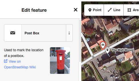
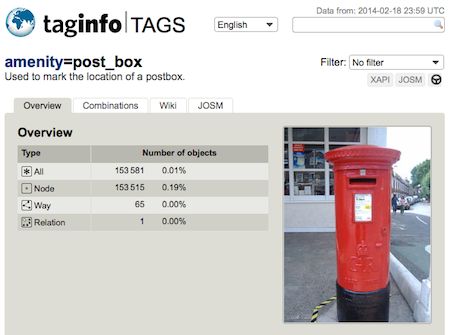
- Jochen Topf announced that Taginfo (a system that finds and aggregates information about OSM tags) has been moved on an OSMF Server. Harry Wood provides some additional information in his OSM blog post here. Jochen is also working on a data repository where you can test your developed OSM applications.
- A study by the Red Cross stressed that armchair-mapping can not replace on-the-ground mapping for the assessment of destroyed buildings.
- DaCor wrote in his “iD Newbie friendly feature request” post about adding IRC functionality to the OSM iD editor.
- Saman Bemel Benrud and “Randomness in map design“.
- OSM contributor SK53-OSM wrote a comprehensive blog post about the (in)correct OSM tagging of “wood, … or is that forest“.
- OSM contributor igeopr about his “Project: 2014 Puerto Rico Roads Update“.
- OSM Spain has a nice (Spanish) campaign to bring a friend to the OSM project. Similar to the famous “Best of OSM“, they created a “Best of OSM Spain“.
Authors: Pascal & Dennis – (thx @ “Wochennotiz”)