Category Archives: 開放街圖基金會工作小組

Help Us Grow and Diversify OSMF Membership Worldwide

by Arnalie Vicario

Welcome to the 2024 OpenStreetMap Foundation Membership Campaign!

Today, members of the OpenStreetmap Foundation (OSMF) Board and several of the OSMF Working Groups are launching a worldwide OSMF Membership campaign with the goal of growing and diversifying OSMF membership in regions where there are no or very few OSMF members.

As you can see from this map, there are many such regions.

A visualization of OSMF membership by country, worldwide

OSM is known for being built by a vast, global community of mappers, GIS professionals, community builders, developers, engineers, trainers, etc. over the last twenty years of the map’s existence, all of whom contribute their local knowledge and maintain open and free geospatial data.

The OSM Foundation administers and supports the making of OSM by overseeing OSM’s technological systems and data. It also helps steer the long-term strategy and well-being of the map.

So, it’s very important to have the membership of the OSM Foundation be reflective of the vast diversity of its community.

Why Do We Need an #OSMFMembershipCampaign?

As headlined on the OSMF website, the OpenStreetMap Foundation is dedicated to encouraging the growth, development and distribution of free geospatial data and to providing geospatial data for anyone to use and share.

It’s important to note that you don’t have to be a member of the OSM Foundation to make a profile on OSM.org and begin editing OpenStreetMap. You don’t even have to be a member to volunteer for a local community or a Working Group, or go to a State of the Map event or participate in a mapping party.

However, if you want to make a difference in the overall future of OSM, becoming an OSMF member is a good idea. For example, OSMF members are entitled to vote in the affairs of the Foundation, including to select members of the Board. OSMF members can also self-nominate for the Board. As you can see from its charter, the OSM Foundation values OSM contributors, and the OSMF membership exists to give dedicated contributors a voice in how the Foundation is run. 

However, of 16 January 2024, there are just 1,929 OSMF members. This is a small percentage of the overall number of active mappers in OSM. (Pascal Neis has provided many resources, including this one, which show the data about the tens of thousands of people who are mapping at any one time and the millions who have mapped over the last 20 years.)

The fact that there are only 1,929 OSMF members means that just a tiny percentage of OSM’ers are electing the board and helping shape the OSM strategic plan and finances.

Further, here is the regional distribution of the 1,929 OSMF members.

To be successful at its goal to represent the interests of the OSM community, the OSMF must increase its membership in regions and countries where there are no or very few OSMF members.

The only way this will happen is if many thousands of OSM users decide to join the OSM Foundation as a member–TODAY!

What Are The Benefits of Being a Member of the OSMF?

  1. You get to play a direct role in choosing the leadership of the OSM Foundation. OSMF members vote every year at the Annual General Meeting, usually held in December, to elect the people who serve as volunteers on the OSMF Board. Importantly, you have to be a member in good standing 90 days before the election, so the time to join is now.
  2. If you’re a member during the 180 days before the General Meeting, you can self-nominate to serve as a member of the OSMF Board. This allows you to influence the strategic plan, some of OSM’s finances and other matters of governance.
  3. You show your support for the map and the community.

    Here are additional reasons.

Please help shape the future of OSM by joining the OpenStreetMap Foundation

I Want to Help with the #OSMFMembershipCampaign

  1. Be a Campaign Ambassador!
  1. Join the Team! Comment on the Call for Volunteers thread in the OSM Community Forum.
  • We are specifically looking for volunteer translators who can help us translate into different languages, specifically:
    • French
    • Spanish (Juan)
    • Arabic
    • Portuguese
    • Swahili
  • We are also looking for help to explore other spaces where we can reach OSM community members, for example by organizing webinars, researching spaces e.g. podcasts where we can promote the campaign, and going live on social media (e.g. Facebook, TikTok, Instagram, etc.).

Here is the OSMF Membership Drive 2024 Plan on the OSM Wiki.

For any additional questions and comments, reach out to us via the OSM Community Forum thread.

We appreciate your help and look forward to growing and diversifying OSMF membership with you!

The OSMF Membership Campaign Team


The OpenStreetMap Foundation is a not-for-profit organisation, formed to support the OpenStreetMap Project. It is dedicated to encouraging the growth, development and distribution of free geospatial data for anyone to use and share. The OpenStreetMap Foundation owns and maintains the infrastructure of the OpenStreetMap project, is financially supported by membership fees and donations, and organises the annual, international State of the Map conference. Our volunteer Working Groups and small core staff work to support the OpenStreetMap project. Join the OpenStreetMap Foundation for just £15 a year or for free if you are an active OpenStreetMap contributor.

OSM.org 社群頁籤登場

現在有新的尋求 OSM 社群與尋求連結的新方式。

在 OSM.org 網站右上角的地方,如今你可以找到連結正式在地組織,以及其他類型的 OSM 社群,單一、集中一處的「社群」頁籤。 目前有相當多的社群了,而 OSM 一直持續成長,因此是個好時機來用更顯目的方式來連結。

根據 LCCWG 成員 Joost Schouppe 說法,新的頁籤「大概是從引入註解系統之後,  osm.org  網站最為顯著的變動了。」

當你瀏覽到新的「社群」頁面時,你會看到透過 OSM 社群索引 (OSM Community Inde, OCI) 動態呈現的在地組織列表資料。 事實上,最困難的部分是怎麼將 OCI 資料整合進頁面,而非只是靜態方式,簡單添加在地組織的內容。 而就如同網站維護人員 Andy Allan 指出:「後面的方式會相對快速與簡單,但是採用 OCI 意味著當增加新組織時能夠自動更新,也意味著再次利用我們已經支援的 46 種語言的在地組織的翻譯名稱。」  
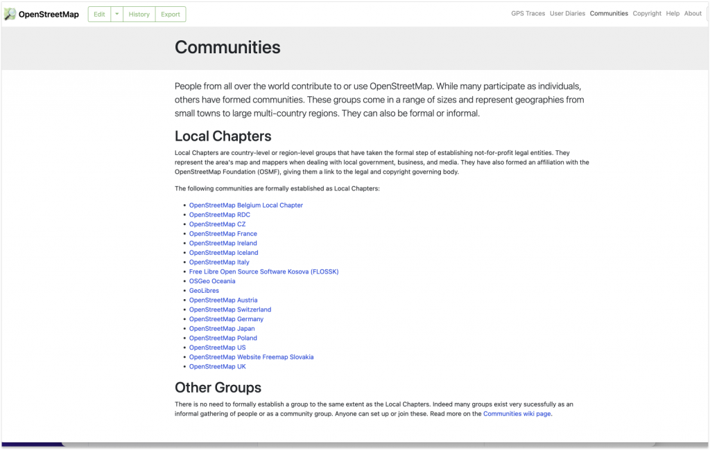
儘管還沒有動態抓取所有其他,比較沒有那麼組織化的社群的方式,加上「其他組織」段落則能呈現他們的存在,與指向更多資訊。  

「這只是開始」LCCWG 成員 Adam Hoyle 說,他參與這個計畫。  「理想上這個園地能成長成為人們與社群找到彼此的聚集頁面。 」 

顯示在地組織清單只是我們初步想做的事情,如今技術挑戰都已經解決了。 例如說,新圖客在他們個人檔案設定家位置時,能夠為他們客製化顯示在地討論區、畫地團團魯以及溝通頻道清單在他他們的個人儀表板上。 

要讓「社群」頁面更加改進,需要社群的付出。 「所有的社群資訊都已經在 OCI 上了,所以我們需要人來擴展整合工作,」Allen 說。Schouppe 補充說:「從 2020 年 10 月開始,這件任務就已經在 LCCWG 的工作清單了,而 Adam 則是從 2021 年 1 月開始進行。由於是用志工時間來進行,因此會需要時間以及精力來改進 osm.org 網站,但我們最終做到了。」

→ 要協助開發 OSM.org 網站,請參閱 主要的 Github 和/或 這個 issue ,會顯示已經存在的 pull requests 與給予你怎麼參與貢獻的點子。

→ 要幫助 LCCWG 來壯大在地社群成長,請 加入他們的頻道

 我想要感謝 Adam Hoyle 的貢獻以及他的耐心來完成整個工作。  要達成目標所需要的技術基礎,花了些時間但為了未來發展仍需要做;另外也得與 OCI 背後的團隊接洽,請求他們更動一些事情來幫助我們取得翻譯  完成工作並且更為容易。-Andy Allan


The OpenStreetMap Foundation is a not-for-profit organisation, formed to support the OpenStreetMap Project. It is dedicated to encouraging the growth, development and distribution of free geospatial data for anyone to use and share. The OpenStreetMap Foundation owns and maintains the infrastructure of the OpenStreetMap project, is financially supported by membership fees and donations, and organises the annual, international State of the Map conference. Our volunteer Working Groups and small core staff work to support the OpenStreetMap project. Join the OpenStreetMap Foundation for just £15 a year or for free if you are an active OpenStreetMap contributor.

提醒:徵求資料模型的回饋意見

資料模型研究

開放街圖基金會工程工作小組在 2022 年開始時進行改進既有資料結構的研究。 Jochen Topf 已經發佈研究的成果了,包括更新資料模型來改進程式處理效率以及更近用性的建議。

有兩項重大建議:

  • 新增加代表區域的資料類型
  • 移除沒有加標籤的節點

社群諮詢

為了達成改革過程的下一步,需要與社群的開發者有更多討論,因為更動資料模型會直接、間接影響開放街圖的軟體。

可能的好處

處理區域不會那麼麻煩

有些圖客可能很訝異怎麼 OSM 還沒有區域資料型態。 畢竟,iD 編輯器的特色,是用按鈕來區別畫點、線條以及區域等功能。 當你畫了,這些區域會如同你預期的那樣出現。 OSM wiki 頁面指明那些標籤用在區域,即便 Overpass Turbo 讓你能在檢索時指定搜尋區域。

除了這些情境之外,然而,這些區域都是用線段或是關聯來代表。 每一個處理 OSM 資料的工具用他們自己設定的規則來猜測這些路徑是代表線段還是區域。 容納區域變成 OSM 資料模式適當的一部分,可以使得不同應用程式能一致解讀資料 ,讓 API 阻止上傳壞掉的區域 ,而且最終能支援部分下載相當大的區域。

保持 OSM 資料處理可及性

目前,路徑是由節點的參照組成,我們依據這些參照來決定路徑怎麼彼此連接。 解析這些節點代表的座標在現今開放街圖的工具當中很花費資源,即便在適合的硬體規則通常要花上數小時甚至一天的時間。

未來我們也許會將路徑簡化變成座標清單 – 視我們之後的改進措施。 這項措施會大幅提昇效能,但遺棄未有標籤的節點是相當大的變動。

最初也許會覺得效能的改進並不是特別值得大家興奮的事情。 但是會讓直接處理我們的資料更為容易,也會顯示開放街圖能夠如何最大程度影響全世界。 就像 Jochen 觀察到:「目標是維持 OSM 是相當寶貴的資源,不只是上億市值的公司能夠運用,還有想在自己筆記型電腦創作世界地圖的學生,或是倡議者運用募捐來的二手電腦來處理資料。」

更好的 OSM 歷史

許多圖客對於網站的歷史頁籤實際能夠顯示的資訊,其實很少相當失望。 已經有相當多工具,例如 OSMCha 與 Achavi 能提供更進階的功能,但仍需要一定程度的知識才能運用。

你也許會問為什麼,而答案則相當技術 – 某一版本的路徑的位置,在許多狀況下,並沒有定議。 這就是為何變動追蹤仍然是相當專家等級的事情,而且是相對新手不友善的工具。 藉由改變資料模型來突破困境,之後我們可以預期有更為永續維護的工具,但一切都需要在取得適當的路徑座標與版本資訊。

分鐘間距更新的向量圖磚生成

如今已經有相當多成熟的向量圖磚生成器了,但仍有一些問題。

  • 一個需要討論的地方是那些圖徵應該出現在 openstreetmap.org 的向量圖磚上面
  • 其他還有為了可接受的效能,如何調和分鐘間距更新與向量圖磚。

這項任務將因為平行化處理圖磚生成,以及搞清楚變動的路徑屬於那個圖磚的麻煩步驟,而變得指數型簡單。

我們也許能找到某方獲得所需的運算資源來做這件事情。 但即便如此,這仍然會大量依賴這位伙伴。

所以啊,要做到向量圖磚,首先得改變資料模型,不然就得依靠高價的特規硬體來保持分鐘間隔更新。

關於未來種種歡迎開講

不能避免的改變。 由於 OSM 資料的成長速度快過硬體效能的增長速度,而 ID 為主的模式意味著整個過程無法用平行化處理來全面加快速度。 追趕地圖改變也許在過去是可行的 ,但如今需要更多奇淫技巧。 未來總有一天,特規硬體要達成分鐘間隔更新也會相當吃力。

然後,有相當多的方式能夠迎接上述挑戰。 如今是開發者社群邁向未來,表達意見的機會。


OpenStreetMap Foundation(OSMF,開放街圖基金會)是一個非營利組織,是為 OpenStreetMap 專案提供支援而成立。 基金會致力於推動自由地理空間資料(geospatial data)的成長、發展和發布,供任何人使用和共享。 OSMF 擁有並維護 OpenStreetMap 專案的基礎設施,這一切有赖於由會費收入和捐款資助,OSMF 同時也組織國際年度會議 State of the Map (SotM) 。 我們的志願者工作小組和一小群核心員工致力為 OpenStreetMap 專案發展提供協助。若有意願加入 OpenStreetMap 基金會的話,每年會費只需 15 英鎊;而如您是活躍的 OpenStreetMap 貢獻者,則可以免費加入。