Monthly Archives: June 2022

Open Social Media at OpenStreetMap

The OSMF is pleased to financially support the en.osm.town OpenStreetMap Mastodon (or “Mapstodon”) service.

The OpenStreetMap Foundation has had a Free & Open Source Software Policy, and a committement to open communication channels. We exist to support the OpenStreetMap project.

Mastodon (aka “The Fediverse”) is a distributed social media network, based on the ActivityPub internet standard. It’s been featured on the New York Times, Vice and Wired. Think of Twitter, but based on open internet protocols, and allowing each community to define its own rules and build its own local community. The Fediverse has a reputation of being nicer and more respectiful than some of the more combative social media spaces.

The en.osm.town Mastodon Mapstodon instance was set up in July 2018 and has been steadily used by hundreds of OSMers over the years. Since the start, we’ve been using the excellent service from Masto.host to host this little corner of the fediverse. Some of the Mapstodon users have been spreading flyers at in person State of the Map conferences. Since this little community has been constantly active and helping each other, the OSMF decided to step up and help support this, and fund it directly.

Our own FOSS Policy Special Committee, and Communication Working Group had recommended this action.

The server was founded & administred by @amapanda@en.osm.town, with moderation from others. (Although Amanda is on the OSMF Board, this is separate from the Board). While the OSMF is funding this project, there will be no change to the moderation & administration of the server. The OSMF “supports, but does not control” OpenStreetMap.

If you want an easy way to mirror your posts to Mastodon, you can use a “Cross Poster” like the Mastodon-Twitter Crossposter or Moa.party. Many OpenStreetMap twitter accounts have set up cross posters, such as State of the Map, twitter @sotm is @sotm@en.osm.town, or the main OpenStreetMap Twitter account (@openstreetmap) is @openstreetmap@en.osm.town

So, sign up, get your pineapple, start tooting and boosting, and have fun! 🙂

The OpenStreetMap Foundation is a not-for-profit organisation, formed to support the OpenStreetMap Project. It is dedicated to encouraging the growth, development and distribution of free geospatial data for anyone to use and share. The OpenStreetMap Foundation owns and maintains the infrastructure of the OpenStreetMap project, is financially supported by membership fees and donations, and organises the annual, international State of the Map conference. Our volunteer Working Groups and small core staff work to support the OpenStreetMap project. Join the OpenStreetMap Foundation for just £15 a year or for free if you are an active OpenStreetMap contributor.

Mastodon logo used here under the GNU Affero General Public License
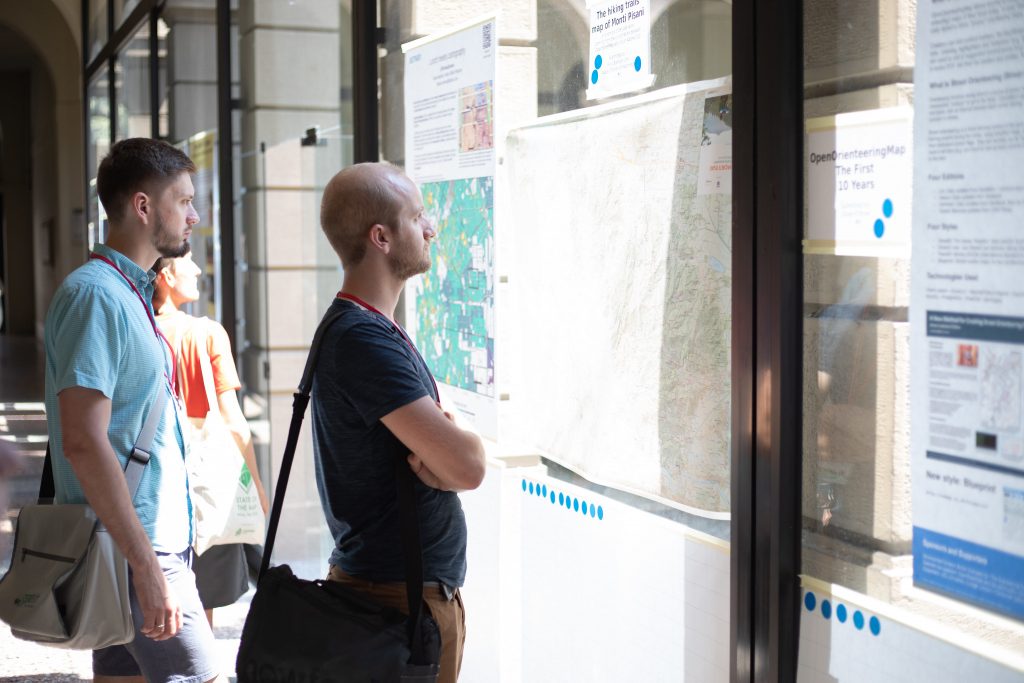
Call for Posters – SotM 2022

Viewing SotM 2018 posters. Photograph by Thomas Skowron, CC BY 2.0

Building on the previous State of the Map culture, we love to hear what has been done with OpenStreetMap data, but we also love to see more, SotM 2022 invites you to submit a poster today.

Your poster could show how well your home region is mapped; it could be a beautiful new style or map. It might focus on a community project or statistics; it might be a poster explaining and inviting people to OpenStreetMap. What is important is that we want it to be about OSM. We are also welcoming academic posters about research around OpenStreetMap data.

For inspiration, see SotM 2021 posters – https://2021.stateofthemap.org/posters/

Submission requirements

  • The poster should be for A0 size (841×1189 mm)  
  • The poster should be related to OpenStreetMap
  • The poster should be open, innovative, and transparent (no copying)
  • The poster must be your own work (individual, team, or institution)
  • The poster should be under an open license (CC-BY-SA 3.0 or later recommended or CC0 )
  • Maximum two entries per person, team, or institution

How to enter

  • Upload your poster via https://files.osmfoundation.org/s/xKeT6JRapjWBAgC
  • File size maximum 30-40 MB
  • Format: PDF
  • Please email sotm@openstreetmap.org with a description of your poster. For example, the background of the project or whatever you consider important to mention in the context of the poster – all that you would tell people if you show them your poster. We will publish this text together with the poster on the SotM website.
  • Please also mention the filename of the uploaded poster in your email, so that we can know which of the uploaded posters is yours.

Timeline

  • Deadline: 31 July 2022

The SotM team hopes to shortlist up to 20 posters that will be published on our website and some other SotM channels under CC BY SA 3.0 (or later)

SotM Organising Committee

Sign up for event updates and follow us @sotm!

Do you want to translate this and other blog posts into your language…? Please email communication@osmfoundation.org with the subject: Helping with translations in [your language]

The State of the Map conference is the annual, international conference of OpenStreetMap, organised by the OpenStreetMap Foundation. The OpenStreetMap Foundation is a not-for-profit organisation, formed in the UK to support the OpenStreetMap Project. It is dedicated to encouraging the growth, development, and distribution of free geospatial data for anyone to use and share. The OpenStreetMap Foundation owns and maintains the infrastructure of the OpenStreetMap project. The State of the Map Organising Committee is one of our volunteer Working Groups.

OpenStreetMap was founded in 2004 and is an international project to create a free map of the world. To do so, we, thousands of volunteers, collect data about roads, railways, rivers, forests, buildings, and a lot more worldwide.  Our map data can be downloaded for free by everyone and used for any purpose – including commercial usage. It is possible to produce your own maps which highlight certain features, calculate routes, etc.  OpenStreetMap is increasingly used when one needs maps that can be very quickly, or easily, updated.

Announcing SotM 2022 Tickets and Program

Petar Milošević, CC BY-SA 4.0, via Wikimedia Commons

The State of the Map Working Group is happy to announce that tickets and program are now accessible through the SotM 2022 website at https://2022.stateofthemap.org/programme/

Tickets
OSM contributors and enthusiasts can now purchase tickets to attend the SotM conference in person or online, via https://2022.stateofthemap.org/tickets/.

There are two different ways you can attend this year:

Florence Ticket
This is the ticket to attend the conference in person in Florence. This ticket includes meals at the conference’s breaks and social events. If you are contributing to OpenStreetMap as a hobbyist, you may choose the discounted Community Ticket. Otherwise please get a Regular Ticket.

Venueless Ticket
This is the ticket to attend the conference remotely. This will give you access to the conference talks, and a chat to interact with other participants and allows you to send questions to speakers during Q&A sessions.

Early Bird Ticket
We are offering limited Early bird tickets at a discounted price until 1 July 2022 at 23:59 UTC. Regular ticket price will apply after.

Program (General Track)
We thank everyone who submitted their proposal to speak and organize a session at SotM 2022! We received a lot of amazing proposals and we are delighted to share the first version of our programme for the General Track, now accessible via https://2022.stateofthemap.org/programme/

We will provide continuous updates on the programme (including the Academic Track Programme).

Stay tuned for more updates about State of the Map 2022!
For any questions, do not hesitate to contact us at sotm [at] openstreetmap.org or join the Telegram channel to interact with other SotM conference-goers at https://t [dot] me/sotm2018

See you in Firenze and online!
The State of the Map Working Group

Do you want to translate this and other blog posts into your language…?  Please email communication@osmfoundation.org with the subject:  Helping with translations in [your language]

The State of the Map conference is the annual international conference of OpenStreetMap, organised by the OpenStreetMap Foundation. The OpenStreetMap Foundation is a not-for-profit organisation formed in the UK to support the OpenStreetMap Project. It is dedicated to encouraging the growth, development and distribution of free geospatial data for anyone to use and share. The OpenStreetMap Foundation owns and maintains the infrastructure of the OpenStreetMap project, and you can support it by becoming a member. The State of the Map Organising Committee is one of our volunteer Working Groups.

OpenStreetMap was founded in 2004 and is an international project to create a free map of the world. To do so, we, thousands of volunteers, collect data about roads, railways, rivers, forests, buildings, and more worldwide.  Our map data can be downloaded for free by everyone and used for any purpose – including commercial usage. It is possible to produce your own maps which highlight certain features, calculate routes etc.  OpenStreetMap is increasingly used when one needs maps that can be quickly or easily updated.

Towards an improved data model for OpenStreetMap

We all know and love the OpenStreetMap data model with its nodes, ways, and relations and the open tagging that has allowed OpenStreetMap to be so innovative. But the data model also shows its years and some improvements might be possible. There is a lot we don’t want to change. Especially the open tagging model has proven itself. We might think of some small improvements, but the core idea of allowing any number of key-value (string) tags has worked amazingly well.

But there are some pain points due to the way we organize our data. The biggest problem is that geographic location is only available to nodes and not higher-level geographic objects like ways and relations. This means that accessing the location of, say, a way always means we have to follow the references to the member nodes of that way. This makes processing OSM data extremely cumbersome and resource-intensive.
The other major pain point often talked about is the missing “area” datatype. We use work-arounds like closed ways and multipolygon relations, but that has always been problematic, because we can’t be sure that those objects are actually valid polygons.

The OSMF Engineering Working Group (EWG) has commissioned me (Jochen Topf) to write a study over the next months outlining the problems with our current data model, possible improvements and their impact on our systems. Any changes to our data model will, of course, have a large impact on our mappers, the data users, our software and on the whole OSM ecosystem. So the study will also suggest ways to move forward implementing those changes step by step.

You are welcome to contact me via email at jochen@topf.org if you want to discuss any of this. After my talk at the State of the Map in Milano in 2018 in which I already outlined some of the issues with the data model, I created the osm-data-model repository. Feel free to comment there. After my preliminary study I will expect there will be a more formal discussion process where we can decide as a community which (if any) changes we want and how we are going to implement them.

The OpenStreetMap Foundation is a not-for-profit organisation, formed to support the OpenStreetMap Project. It is dedicated to encouraging the growth, development and distribution of free geospatial data for anyone to use and share. The OpenStreetMap Foundation owns and maintains the infrastructure of the OpenStreetMap project, is financially supported by membership fees and donations, and organises the annual, international State of the Map conference. Our volunteer Working Groups and small core staff work to support the OpenStreetMap project. Join the OpenStreetMap Foundation for just £15 a year or for free if you are an active OpenStreetMap contributor.