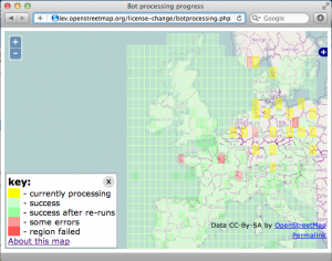
Over the past week the license change redaction bot has made automated redactions, sweeping across our entire worldwide dataset. The whole globe was covered yesterday. There has been substantial technical effort involved in developing and running the software to make those changes, and a fair degree of uncertainty about how long it would take, so this is a significant milestone. Congratulations and thanks are in order to all those who helped achieve it, and especially to Matt Amos, Andy Allan, Gnonthgol and MonkZ who carried out most of the coding work.
The data now in the live OpenStreetMap database is largely in a state where it can be declared ODbL licensed, however the license hasn’t changed yet. We will be posting a further update when this is imminent.
More than 99% of the data has been retained, and in most places, the difference is barely noticeable. There are, however, some areas of our map where the redaction was concentrated, in particular Poland and Australia. Though we would of course have preferred to retain this data, we do respect the original contributors’ decision, and we thank them for their past involvement in the project.
Fortunately the OSM community’s response in these areas has been magnificent and we believe we will be back to having a high-quality dataset in these areas in a short space of time. If, as an OSM mapper, you would like to help – by using aerial imagery and other sources, or ideally, from personal knowledge and survey – then please do get involved. Essentially we’re left with some new blank spots on the map, and can respond with the process we know and love. Use your favourite mapping techniques, go explore and fill in the blanks. (Note that you must not copy from CC-BY-SA datasets or map views based on the pre-redaction data; please treat this like you would any other incompatibly copyrighted map data.) We can begin this process in earnest now while final preparations for license changeover are made.


