Monthly Archives: February 2011

Image of the Week: OpenSeaMap and weather

Media_httpwikiopenstr_wtkrs

OpenSeaMap showing weather information for a storm in the North
Atlantic ocean on 14 February 2011

OpenSeaMap web site

This is a Featured image, which means that it has been identified as
one of the best examples of OpenStreetMap mapping, or that it provides
a useful illustration related to the OpenStreetMap project.

If you know another image of similar quality, you can nominate it at

http://wiki.openstreetmap.org/wiki/Featured_image_proposals

Weekly OSM Summary #11

02/14/2011 – 02/24/2011

A summary of all the things happening in the OpenStreetMap world:

  • The True Offset web service is available since last week. True Offset aims to create a database of correction data for aerial imagery offsets.
  • The call for papers for this year’s SOTM.EU in Vienna is still open till the 28th of February. All the accepted speakers will get a free ticket to the conference. The organizing team is also looking for sponsors for the conference.
  • Travel Discounts for the SOTM conference in Denver are now available.
  • JOSM (latest) now supports MapCSS, a CSS like map style language this is also used by Potlatch 2.
  • ScanAerial is the successor of the JOSM plugin “Fuzzer” for the automatic tracing of seas and other water areas. The developer is looking for people to test the plugin and report bugs.
  • Forum user kendzi has developed a JOSM plugin that displays the scenery in 3D.
  • User:vvoovv has found a way to use Google Sketchup as an OSM editor.
  • OSMembrane is a new java application that offers a graphical user interface for Osmosis, the popular command line tool for manipulating large quantities of OSM data.
  • KeyPadMapper is an Android App specialized for mapping of house numbers.
  • The new MapQuest Android App has a dedicated OSM mode.
  • TileMill is a new open source map designing studio.
  • A chart visualizing “the most prolific contributors in the region and how contribution volume (not to be confused with quality!) changes over time.”
  • Maxim Dubinin has created some stats about the OSM community in Russia.
  • A new import is starting in Georgia.
  • DIY-StreetView is yet another initiative to make an open street view.
  • MapQuest is looking for projects that use its open services and could be presented at SXSW.
  • Everyone who missed the HOT conference call can listen to a recording of it and look at the notes here.
  • Steve Coast is looking for someone to take over future development of Transiki.org.

Authors: Pascal, Jonas & Dennis
Did we miss something? Do you want to help us collecting the news for next week’s issue? 
You can contact us via mail or Twitter.


Project of the Month: Bridges and tunnels

Bridges and tunnels assist travel. They span barriers that otherwise
impede travel such as mountains and ravines. They also reduce the
interaction between travelers in cases such as grade-separated railway
crossings, and motorway interchanges.

The Project of the Month is to add local bridges and tunnels to the map.

See the bridge and tunnel project page for more details and results.

This is the a Project of the Month. Project of the Week returns
next week, while PotM will continue until the end of March. These projects
inspire mappers to contribute data they might not have considered
previously, and allow us to be inspired by the projects of other
mappers.

This is your Project of the Month. Make suggestions. Inspire other
mappers. What is it about contributing to OpenStreetMap that
interests you? Postboxes? Bowing alleys? Share your OpenStreetMap
interests with other mappers by contributing a Project of the Month.

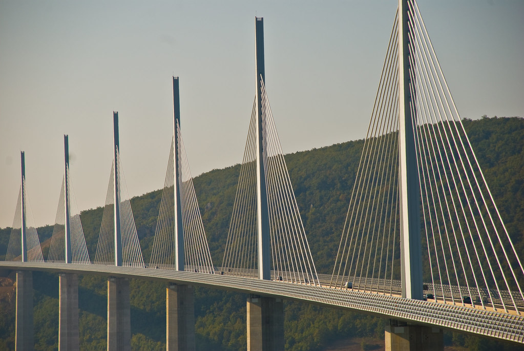
Photo of Millau viaduct by Philiip Capper is
licensed CC-By.

Nice simple animation of OSM growth

… and some basic stats ;

“A simple way of getting an idea of the coverage expansion trends is to look at the historic data. This article aims to provide visualizations for two elements: where was the coverage expansion happening and how did it break down on a weekly basis.

Beyonav has performed a statistical analysis on over 600GB compressed (10 TB uncompressed) weekly Planet-OSM database dump files since December 30th, 2009.”


http://www.beyonav.com/sites/beyonav/osmanalytics.aspx#

United Airlines official travel partner for State of the Map

Flying to Denver in September? United Airlines is proud to be the offical airline for State of the Map 2011.

No matter where you are coming from, you can look to get 5%- 20% off your travel fare. 

For more details and our travel discount code, visit stateofthemap.org or the travel wiki page for the fine print.

United_plane

United airplane photo by http://www.flickr.com/photos/scepdoll/ is licensed CC-Byhttp://creativecommons.org/licenses/by/2.0/deed.en

Project of the Week: Food Bank

Media_httpuploadwikim_gnqwu

Sometimes we map for ourselves, other times we can map for others. The
Project of the Week is to add local food banks to the map.

Learn more about this Project of the Week on the wiki.

This is your Project of the Week. Make suggestions. Inspire other
mappers. What is it about contributing to OpenStreetMap that
interests you? Postboxes? Bowing alleys? Share your OpenStreetMap
interests by contributing a Project of the Week.

Food bank photo by http://www.flickr.com/people/27112995@N02 is licensed CC-By http://creativecommons.org/licenses/by/2.0/deed.en

Weekly OSM Summary #10

02/01/2011 – 02/14/2011

A summary of all the things happening in the OpenStreetMap world:

  • Bing launched an experimental service, which automatically traces ways from aerial images; A JOSM plug-in can be found here (JOSM-Plugin) and a demo without Silverlight here (Demo). More information about the official announcement and the method that is being used can be found at Andrew Turner’s blog post: “Automatic Road Detection – the Good and the Bad” and at Microsoft’s project member Ido Omer’s post at OSM-Talk.
  • The openstreetmap.de map has a new style! It is the result of collaboration work between Beate Braun’s bachelor-thesis and Geofabrik. The design is based on the Mapnik-Style and has a few new adjustments.
  • OpenCycleMap gets some small updates too – Here you can read more in Andy’s blog.
  • A new program visualizes OSM in 3D. A lot of developers that are currently working on topics that include OSM and 3D can meet at an OSM Wiki page now.
  • A flow animation of hiring bikes in London based on OpenStreetMap.
  • The future of Tiles@Home and how it could go on. Up to now the server and clients are not active yet and still under development.
  • New blog post by the Working Groups of the OSM-Foundation.
  • A User has been banned from the OSMF by the Data Working Group. He was tracing data from Google Maps. All his edits in OpenStreetMap have been deleted. Read more in the OSMF-talk mailing list.
  • Matthias Meißer is working on a worldwide Map of OSM usergroups. Germany has already such a map at openstreetmap.de.
  • A new project, OpenDEM, would like to collect an “Open Digital Elevation Model (OpenDEM)” of the world.
  • New Zealand starts its own OSM portal: www.openstreetmap.org.nz.
  • Really nice “Point-of-Interest (POI)” map-demo for Paris: http://demo.3liz.fr/osminterest
  • SPOT donates images of the Ivory Coast for HOT.
  • You can register for the next SotM now! The conference will take place in Denver, Colorado from September 9th until September 11th,2011; some early registration discounts are available here (link). More Information can be found in the Wiki. Also, the winner of the Logo competition has been announced. Congratulation!
  • The upcoming WhereCampEU will take place in Berlin (May 27th and 28th).
  • February 16th, 2011 is a public HOT conference call.
  • The next “Open Knowledge Conference” (OKCon 2011) will be held in Berlin from June 30th till July 1st (via Talk-de).
  • Christoph Eckert wrote a blog post about the OSM-booth at the “Horizont Outdoor“ in Karlsruhe.

Authors: Pascal, Jonas & Dennis
Did we miss something? Do you want to help us collecting the news for next week’s issue? 
You can contact us via mail or Twitter.