Monthly Archives: November 2010

Microsoft Imagery details

“Microsoft is pleased to announce the royalty-free use of the Bing Maps Imagery Editor API, allowing the Open Street Map community to use Bing Maps imagery via the API as a backdrop to your OSM map editors.

Bing Maps imagery must be used in accordance with the API Terms and Conditions [see PDF below] – although this is not legal binding advice, and you are encouraged to read the TOU itself, in sum the TOU says: you are only granted rights to use the aerial imagery, you must use the imagery as presented in the API, you cannot modify or edit the imagery, including the copyright and credit notices; you cannot create permanent, offline copies of the imagery, all of your updates to OSM arising out of the application must be shared with OSM, and the OSM map editor must be free to end users.”


If you have a question, I’m at steve@asklater.com or you can chat to people live at http://irc.openstreetmap.org/ Richard Fairhurst and others have already been working on the code to use this stuff with potlatch etc. You should see it go live soon!

OpenStreetMap editor Potlatch 2 launched

Media_httpwikiopenstr_fwaej

You may have noticed something new in your OpenStreetMap editing
today. Potlatch 2 has now gone live on OpenStreetMap.org. Potlatch 2
is a complete rewrite in ActionScript 3 using the free Flex 3
compiler. Potlatch 2 rendering uses MapCSS and RichardF’s halcyon
rendering library. It’s new. It’s Open Source. And it’s on
OpenStreetMap.org

But, why didn’t I notice it?

That’s a fair question. You might not have noticed Potlatch 2 on the
main OpenStreetMap.org web site because it is now an editor option.
That’s right. If you hover over the Edit tab, you can select from
Potlatch or Potlatch 2. JOSM is also an option if you have JOSM open
with the remote control plugin active. You can set a default editor
in your API user preferences. [Support for the Merkaartor remote
control plugin is coming soon.]

Media_httpimgurcomerc_fxzgk

Potlatch 2 may not be the right editor for everybody. There will be
bugs discovered, and removed as development continues. Consider
adding Potlatch 2 to your editing arsenal, and be sure to report any
bugs you find.

The amazing team behind Potlatch 2 and this update to the web site
includes some of the same people who keep OSM running and have been
making OpenStreetMap great for years.

Richard Fairhurst http://wiki.openstreetmap.org/wiki/User:Richard
Andy Allan http://wiki.openstreetmap.org/wiki/User:Gravitystorm
Tom Hughes http://wiki.openstreetmap.org/wiki/User:TomH
Dave Stubbs http://wiki.openstreetmap.org/wiki/User:Randomjunk
Matt Amos http://wiki.openstreetmap.org/wiki/User:Matt

And thanks extend to many others including all of those who keep OSM
running day to day, all of the Potlatch 2 testers, documenters, and
MapQuest for sponsoring Andy’s development time over the past few
months.

You can see a graphical representation of the development of the
Potlatch 2 code here:

Media_httpwikiopenstr_abcen

Congratulations to the entire Potlatch 2 team and thanks for this new editor!

Developers wishing to contribute to Potlatch 2 will find the code in
svn and can hack on it with the Open Source Flex compiler.

http://svn.openstreetmap.org/applications/editors/potlatch2/README.txt

Open an editing session in Potlatch 2

http://www.openstreetmap.org/edit?editor=potlatch2

Image of the Week: OpenStreetMap data in svg layers

Media_httpimgurcompjc_aimjg

A screenshot of Illustrator showing a SVG file produced by Maperitive.
This new functionality is available in the newest release of
Maperitive.

This is a Featured image, which means that it has been identified as
one of the best examples of OpenStreetMap mapping, or that it provides
a useful illustration of the OpenStreetMap project.

If you know another image of similar quality, you can nominate it at

http://wiki.openstreetmap.org/wiki/Featured_image_proposals

Weekly OSM Summary #3

11/21/2010 – 11/28/2010

Every week a lot of things are happening in the OpenStreetMap (OSM) world. It can be hard to keep track of all the different communication channels and don’t miss any important news. That’s why we’ve created a short summary of all the news here. Enjoy!

For more news, especially regarding new tags and wiki pages, you can check-out the community-updates over here.

Authors: PascalJonas, Matthias & Brice.
We missed something? You want to help us collecting the news for next week’s issue? 
You can contact us via mail or Twitter.


Working Group Summary

Wow. Look at the time. Has it already been three weeks since the last Working Group summary? Why yes, it has. Three weeks and a few days. Sorry about that.  If you like this type of summary, offer feedback in the comments to encourage members of each working group to provide summaries.

Communication Working Group (CWG) 08 Nov 2010

Analytics shows pleasantly high traffic.  Thanks!  Checking settings re RSS feeds.  Discussion of OSMF web site reorganization and theming, target groups for OSMF messages.

Licensing Working Group (LWG) 09 Nov 2010

Revisions to CT(1).  Noted attribution issues in an advertising campaign.  SteveC to follow up.

Board meeting 10 Nov 2010

Google Maps Colombia have removed OSM data after SteveC brought the issue to their attention. They have a one month cache on those tiles so the data may still appear.

Nike have properly attributed OSM in latest Nike Grid campaign except in television commercial and arguably in online videos.

Strategy Working Group (SWG) 11 Nov 2010

Sam to prepare tile policy document on OSM wiki.  Discussion to continue on matters relating to third-party project hosting and financial support.

Communication Working Group (CWG) 15 Nov 2010

Meeting postponed

Licensing Working Group (LWG) 16 Nov 2010

Two guests for this meeting.  Eric Rodenback of Stamen discussed scope of Stamen involvement in NikeGrid campaign, some of which has correct OSM / CC-By-SA attribution.  Richard Fairhurst offered suggestions for CT v1.2.

SteveC advises that Google Maps in Colombia use a one-month cache, so data removed may continue to be visible for a few weeks.  Original reporter to advise.

Communication Working Group (CWG) 22 Nov 2010

CWG is now looking at incoming communication to the Foundation.  How can this be improved?  Why not test a communication channel and use the comments below?

Licensing Working Group (LWG) 23 Nov 2010

Meeting shortened due to low availability of members.  Richard to forward CT 1.2 to legal for comment.

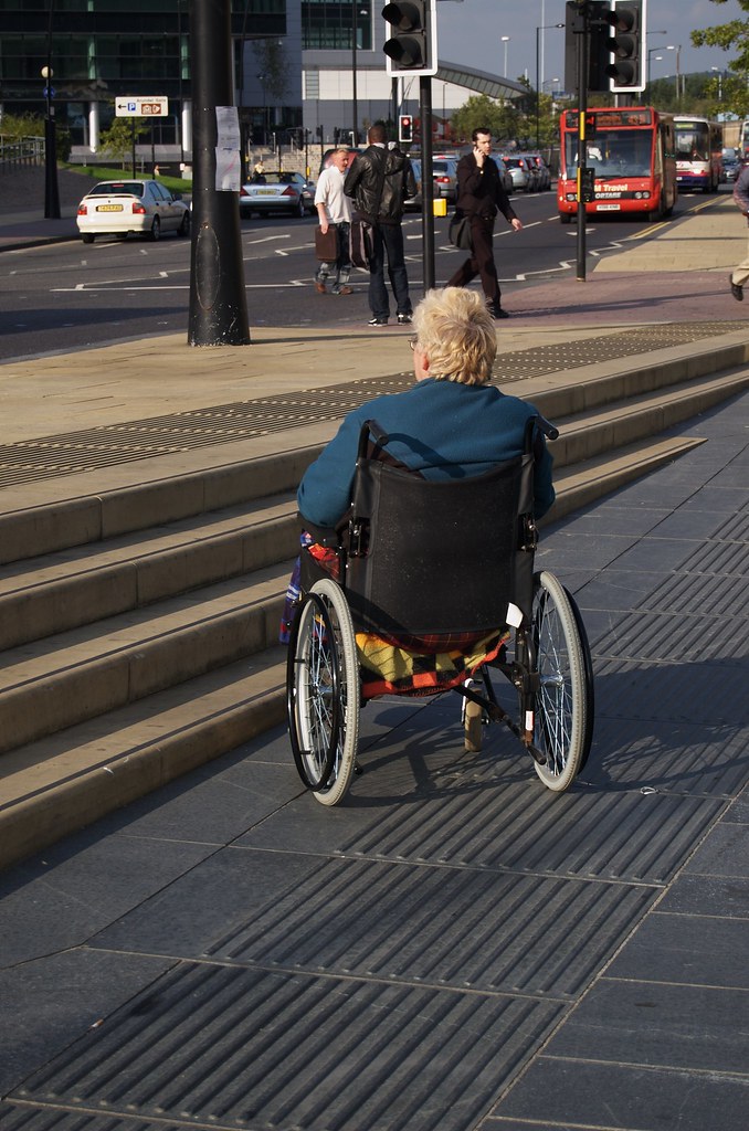
Data Working Group (DWG) 24 Nov 2010

12nm data offer relies on an unacceptable license.  Data not adopted.

Board Meeting 24 Nov 2010

The board recognized Steve Coasts position at Bing and congratulated him.  No conflict of interest is inherent in Steve’s position at Bing and on the OSMF board.  All board members are obliged to excuse themselves when matters of potential conflict of interest arise.

Email from research group seeks official recognition of their use of OSM.  It was suggested that they may have an advantage in their funding by obtaining official recognition.  Simone to draft generic response to groups using OSM in their research since OSM license already grants permission.

Anonymous participation in Board and WG meetings can not be permitted as Conflicts of Interest can not be properly declared and anonymity maintained.

StateoftheMap Organizing Committee / SotM WG  24 Nov 2010

Options for additional sponsorship levels and amounts were discussed.  Eventbright proposed for registration based on success in previous uses.  Accepted separation of sponsorship from speaking opportunities. Vendor stage and exhibition hall discussed.

Considered lightning talks, workshops and BoFs and best ways to implement these with “right level” of organization.

Upcoming tasks are, update web site for 2011, announce call for logos, call for papers, call for sponsors.

Strategy Working Group (SWG) 25 Nov 2010

TWG to receive, evaluate and act on requests for guest tile layers.  Policy on guest tile layers subject to change without warning.

Licensing Working GroupLicensing Working Group

Humanitarian OpenStreetMap Team: Proposal for Knight News Challenge

Media_httphotopenstre_fbghv

The Humanitarian OpenStreetMap Team includes OpenStreetMap
contributors who are particularly interested in the intersection of
OpenStreetMap and humanitarian relief. HOT is applying for a Knight
News Challenge grant. And the grant-writers among them seek feedback
from the larger OpenStreetMap community.

Since the greater OpenStreetMap community has been such a
part of mapping in Haiti before submission we want to get your
feedback. Please look at it and let us know what you think.

Read the full text and their proposal here:

http://hot.openstreetmap.org/weblog/2010/11/hots-proposal-for-the-knight-news…

Project of the Month: Wheelchair accessibility

Navigation, maps and accessibility extend beyond the shortest drive to
a shop and the opening hours. The Project of the Month for December
2010 is to include wheelchair accessibility information as part of
your mapping. Learn more about how to map your maps more accessible
or the project page.

http://wiki.openstreetmap.org/wiki/Project_of_the_week/2010/Nov_24

This is the a Project of the Month. Project of the Week returns
next week, while PotM will continue until January. These projects
inspire mappers to contribute data they might not have considered
previously, and allow us to be inspired by the projects of other
mappers.

This is your Project of the Month. Make suggestions. Inspire other
mappers. What is it about contributing to OpenStreetMap that
interests you? Postboxes? Bowing alleys? Share your OpenStreetMap
obession by contributing a Project of the Month.

http://wiki.openstreetmap.org/wiki/Project_of_the_week/Proposals

Steps and chair photo by Tim Parkinson
http://www.flickr.com/photos/timparkinson/
is licensed CC-By http://creativecommons.org/licenses/by/2.0/deed.en

Image of the Week: OpenStreetMap more prominent on Wikipedia

Media_httpimgurcomia6_rdqva

OpenStreetMap from the no:Operahuset i Oslo Wikipedia page, showing
no:Kontraskjæret as a pop-up link. Screenshot of the Wikipedia page.
See the full size image on Wikipedia or here,

This is a Featured image, which means that it has been identified as
one of the best examples of OpenStreetMap mapping, or that it provides
a useful illustration of the OpenStreetMap project.

If you know another image of similar quality, you can nominate it at

http://wiki.openstreetmap.org/wiki/Featured_image_proposals

OpenStreetMap founder Steve Coast joins Bing

Media_httpiimgurcom4n_xmwoe

When Steve Coast, founder of OpenStreetMap and co-founder of CloudMade
announced in October that he was leaving CloudMade there was no
expectation that he would be idle for long. In the interim he decided
to revolutionize transit data by founding http://transiki.org/ took
some hang gliding lessons and by the way co-organized a great
geo-unconference in Denver last weekend.

But what else has Steve done lately?

He’s decided to revolutionize Bing Maps.

As announced today on his blog Steve Coast will be joining Microsoft
property, Bing Maps as Principal Architect on Bing Mobile.

And Microsoft is donating their global aerial imagery to OpenStreetMap
contributors for use in improving OpenStreetMap.

You will certainly want to read the complete announcement at the following link.

http://blog.stevecoast.com/im-working-at-microsoft-and-were-donating-ima

Update, further information on the Bing blog, here,

http://www.bing.com/community/site_blogs/b/maps/archive/2010/11/23/bing-engag…

Congratulations, Steve!