Monthly Archives: October 2010

Project of the Week: Potlatch 2

Media_httpwikiopenstr_ddbsr

You know it. You love it. It’s the editor on the main OSM web site.
It’s Potlatch and it’s had some serious renovations. It’s so new that
now it has a new name, “Potlatch 2”. But before Potlatch 2 can go live
on the OpenStreetMap web site, it has to be put through it’s paces.
After more than a year of development, Potlatch 2 is a complete
re-write of Potlatch. It has new features too numerous to mention, but
for the most important feature; it is an editor for OpenStreetMap. So
let’s test it.

Details and suggestions on the Project of the Week wiki page

http://wiki.openstreetmap.org/w/index.php?title=Project_of_the_week/2010/Oct_13

This is your Project of the Week. Submit your own projects or offer
suggestions to inspire and inform other mappers.

http://wiki.openstreetmap.org/wiki/Project_of_the_week/Proposals

Hardware fund Donation to OSM Foundation from MapQuest

MapQuest have made a donation to the OpenStreetMap Foundation. The
funds will be applied to hardware improvements and will benefit
OpenStreetMap contributors around the world.

http://blog.osmfoundation.org/2010/10/12/donation-for-osmf-hardware-from-mapq…

You can make a donation to OpenStreetMap as well, via the donation link below.

http://donate.openstreetmap.org/

Donation for OSMF Hardware from MapQuest

MapQuest have made a donation to the OpenStreetMap Foundation. The funds will be applied to hardware improvements and will benefit OpenStreetMap contributors around the world.

The OSMF would like to thank MapQuest for their donation, as do, I’m sure, the more than 311,000 OpenStreetMap contributors who will see the benefits of the improved hardware.

You can make a donation to OpenStreetMap, too.

Image of the Week: Великие Луки Mapping Weekend

Media_httpimgurcomy6p_ebdse

Великие Луки Mapping Weekend banner: “We’ve come from different cities
of Russia and Belarus to create the best map of Velikiye Luki in the
world”

This is a Featured image, which means that it has been identified as
one of the best examples of OpenStreetMap mapping, or that it provides
a useful illustration of the OpenStreetMap project.

If you know another image of similar quality, you can nominate it at

http://wiki.openstreetmap.org/wiki/Featured_image_proposals

List of relicensing accounts

Matt Amos, of the OpenStreetMap Foundation Technical Working Group, announced the publication of the list of accounts accepting ODbL/CT.

as part of the voluntary relicensing phase of the move to ODbL,
existing contributors have had the ability to voluntarily accept the
contributor terms. to help the community assess the impact of the
relicensing it was planned to make the information about which
accounts have agreed available. this will help with the evaluation of
the process and analysis of any consequent data loss, should the
switch be made. at the last LWG meeting, having been put to the board
for approval, it was decided to make this available [1], and i’m
pleased to announce that this list is now up [2] and being regularly
refreshed from the database every hour.

i look forward to seeing the new analyses, visualisations and tools
that can be built using this data.

cheers,

matt

[1] https://docs.google.com/View?id=dd9g3qjp_86hf7fnqg8
[2] http://planet.openstreetmap.org/users_agreed/users_agreed.txt

Matt’s announcement on legal-talk@openstreetmap.org mailing list can be found in the archives,

http://lists.openstreetmap.org/pipermail/legal-talk/2010-October/004914.html

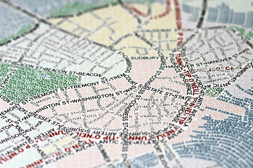
Pretty OSM-derived Art Maps

Media_httpimgurcomixx_bwcxy

I’m not entirely sure what axismaps.com does but it sure seems to
involve a lot of pretty maps. This caught my attention when pointed
out to me by OSM contributor RichardF.

These unique maps of Chicago and Boston accurately depict
the streets and highways, parks, neighborhoods, coastlines, and
physical features of the city using nothing but type. Only by manually
weaving together thousands upon thousands of carefully placed words
does the full picture of the city emerge. Prints are
available.

So, Boston and Chicago, but I’m told that San Francisco, New York and
Washington are in progress, too.

See more pretty maps and wonderful photography of maps on their web site.

http://www.axismaps.com/typographic.php

They have a blog entry describing the process of creating these maps, as well.

http://www.axismaps.com/blog/2010/09/typographic-map-posters/

Project of the Week: At a Crossroads

They are the literal markers along a way; we can go three blocks then
turn north. Crossroads are also the metaphorical points of decision in
our lives; we can come to a fork in the road in deciding between two
job offers. Crossroads are all about decisions; left or right; hold,
raise or fold; ketchup or mustard. This week we map our decisions.

Feel free to map your literal or metaphorical crossroads.

Details and suggestions on the Project of the Week wiki page

http://wiki.openstreetmap.org/w/index.php?title=Project_of_the_week/2010/Oct_06

This is your Project of the Week. Submit your own projects or offer
suggestions.

http://wiki.openstreetmap.org/wiki/Project_of_the_week/Proposals

Signpost photo by Matt Brown
http://www.flickr.com/photos/londonmatt/
Licensed CC-By-SA
http://creativecommons.org/licenses/by/2.0/deed.en_CA