[youtube http://www.youtube.com/watch?v=2ljFfL-mL70?wmode=transparent]
Monthly Archives: September 2010
Old talk from 2006
bcs2006.mp3
Laurence Penney threw me this recording of a talk about OSM I did at the British Computer Society in 2006, or about a million years ago. The slides might be on the interwebs somewhere too.
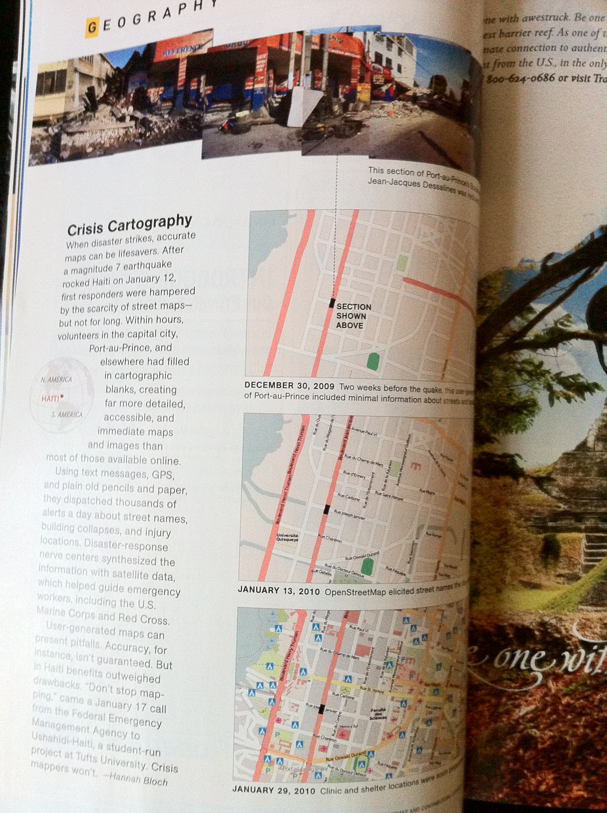
OSM in this months National Geographic
Project of the Week: What are you watching?

What are you watching? Cinemas and theatres can provide diversion and
entertainment. Some places have thriving tourism economies based on
theatre. Other places have numerous jobs for people creating films to
ship around the world.
Add your local cinemas and theatres to OpenStreetMap as part of this
Project of the Week and let the world know more about your
neighbourhood. Find tagging suggestions and more details on the
project page.
http://wiki.openstreetmap.org/wiki/Project_of_the_week/2010/Sep_19
Project of the Week is moving to Wednesday! On 22 September 2010 PotW
will move to announcements on Wednesdays. On 29 September 2010 the
first Project of the Month will be announced and the working title for
that project is Stay a while.
This is your Project of the Week. Make suggestions for projects of
the week or month. Inspire other mappers. What is it about
contributing to OpenStreetMap that interests you? Postboxes? Bowling
alleys? Contribute a Project of the Week and share your interests
with other mappers.
http://wiki.openstreetmap.org/wiki/Project_of_the_week/Proposals
Other Projects of the Week / Humanitarian Mapping Humanitarian
emergencies continue. If you can provide some additional remote
mapping time please consider helping.
http://wiki.openstreetmap.org/wiki/2010_07_Pakistan_Floods
http://wiki.openstreetmap.org/wiki/Project_of_the_week/2010/Aug_15
Watching the Stage photo by woodleywonderworks
http://www.flickr.com/photos/wwworks/
is licensed cc-by
http://creativecommons.org/licenses/by/2.0/deed.en_CA
Another new English OSM book!
The English language OpenStreetMap books are starting to flow, fast
and furious now. A second new OSM book is now announced and is
available for pre-order.
https://www.packtpub.com/openstreetmap/book
OpenStreetMap contributor Jonathan Bennett has sent his final version
to the publisher and expects books to ship this month or early next.
An ebook is also available using the link above.
Mac OS X killed my Garmin 60CSx
OSMer scruss has been doing cool things with OSM, but his GPS receiver
started having problems. Turns out it is the fault of Mac OS X.
So watch out and have a look at his full report for more details.
http://networkedblogs.com/7SEyY
One of the cool things that scruss has been doing is adding wind farm
towers to OSM.

Screenshot from OSM mapnik layer
http://www.openstreetmap.org/?lat=44.06796&lon=-81.64894&zoom=15&layers=M
is CC-By-SA http://creativecommons.org/licenses/by-sa/2.0/
See this contribution in the following changeset
OSM book available in English!

OSMer and co-author, Steve Chilton, reports that the long awaited,
much anticipated, OSM book is coming Real Soon Now. You can pre-order
the book at a discount now, or order it when it becomes available in
five days. I presume that if you wait to order you miss out on the
discount.
This is the OSM book that has seen three editions in German since the
original publication in 2008. I had a peek at a proof version of this
book at the State of the Map in Girona and found it enjoyable and
informative to read. This should be on the bookshelf of every OSMer,
and it will undoubtedly be frequently referred to, dog-eared and
heavily worn.
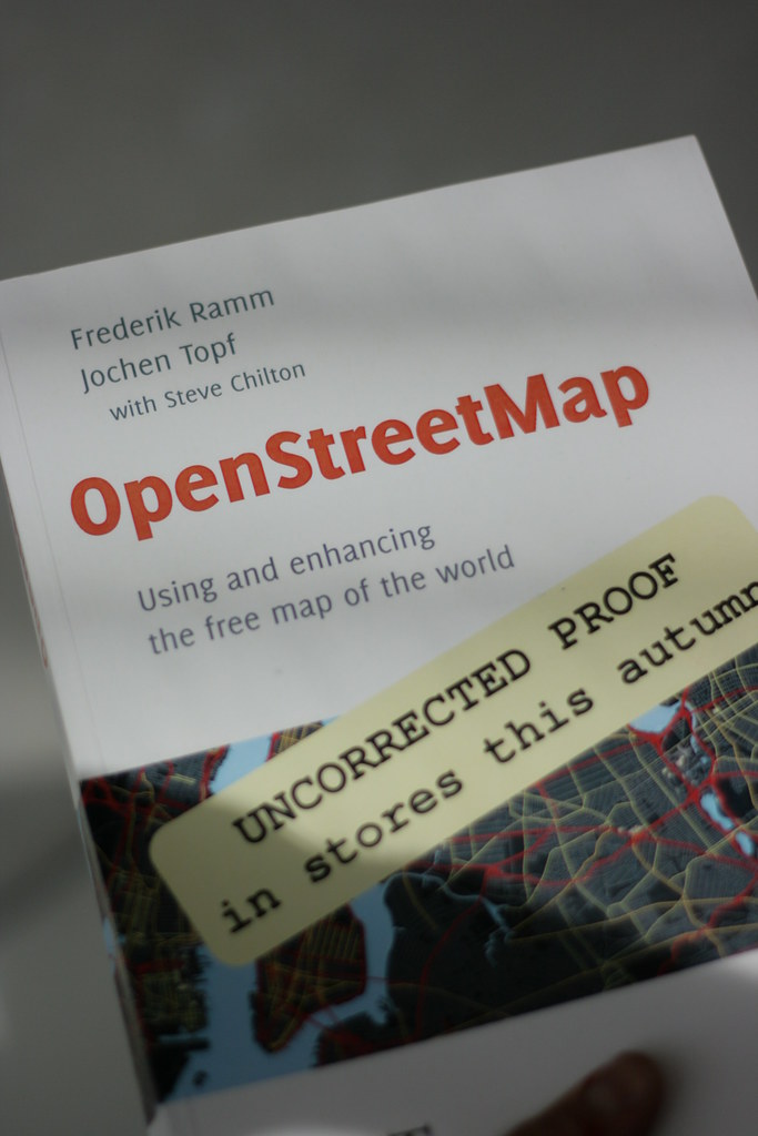
This is the proof of the book, captured in the wild, at SotM10
by OSMer, Chris Fleming, http://www.flickr.com/photos/chrisfleming/
who licensed the photo CC-By-SA http://creativecommons.org/licenses/by-sa/2.0/
Image of the Week: Staffanstorp building outlines
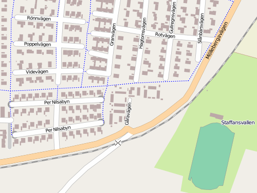
Building outlines in Staffanstorp, Sweden courtesy of the town council
GIS. Uploaded by OSM user lorimar who works in the Staffanstorp
municipality GIS office. You can find Staffanstorp on OSM here.
http://www.openstreetmap.org/?lat=55.6427&lon=13.2117&zoom=14&lay…
Staffanstorp is doing some interesting things with OSM data. Have a
look at the multi-modal router they have, as well. It is a
comparative router that shows recommended routes for pedestrians,
cyclists, driving and public transit, along with the costs in time,
calories and carbon! Very nice, lorimar.
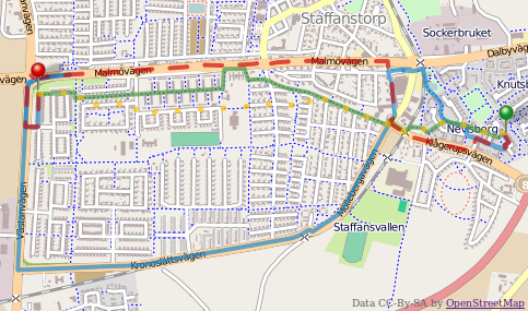
Be sure to switch to display the OSM data layer, it’s much more
detailed than the proprietary data layer. the comparative router was
developed by Staffanstorp’s neighbour, the municipality of Lund.
http://www.lund.se/
http://kartor.lund.se/resejamforaren/start_st.htm
This is a Featured image, which means that it has been identified as
one of the best examples of OpenStreetMap mapping, or that it provides
a useful illustration of the OpenStreetMap project.
If you know another image of similar quality, you can nominate it at
Project of the Week: Parks and recreation

Parks and green spaces add colour to our cities. They provide organic
shapes and textures to the rectilinear world of glass cladding, formed
concrete and rolled asphalt. These urban oases give an opportunity
walk on grass, rather than pavement, to listen to birds rather than
cars, and to picnic in the shade of a tree rather than at a moulded
plastic table.
Let’s add a local park to OpenStreetMap.
Find information on how to add your favourite park to OpenStreetMap,
and a tutorial for newer mappers here.
http://wiki.openstreetmap.org/wiki/Project_of_the_week/2010/Sep_12
This is your Project of the Week. Make suggestions. Inspire other
mappers. What is it about contributing to OpenStreetMap that
interests you? Postboxes? Bowling alleys? Contribute a Project of
the Week and share your interests with other mappers.
http://wiki.openstreetmap.org/wiki/Project_of_the_week/Proposals
Other Projects of the Week / Humanitarian Mapping
Humanitarian emergencies continue. If you can provide some additional
remote mapping time please consider helping.
http://wiki.openstreetmap.org/wiki/2010_07_Pakistan_Floods
http://wiki.openstreetmap.org/wiki/Project_of_the_week/2010/Aug_15
Call for venues: SOTM 2011
Manchester, Limerick, Amsterdam, Girona …. where next? Well, that’s
up to you! The call for venues is now open!
So far, three bids have been presented from three continents. Who
will lead the organizing committee to present a bid for SotM – McMurdo
Station?
To be able to make a good decision your proposal should at least
contain the following information:
* Name of the group or individual applying
* Name, address and short description of the proposed conference venue
* A short impression how the State of the Map 2011 would look like
* Ideas for community-building activities
* Information about the city/region (transport, accommodation, etc).
* An estimate of the costs of the venue and catering
Please have your proposal ready by October 15th 2010.
Get more details and prepare your bids now.
http://wiki.openstreetmap.org/wiki/State_Of_The_Map_2011/Bid