It’s nothing short of spectacular watching the share price of TomTom and other PND manufacturers over the last 48 hours:
What can you say but :-O
It’s nothing short of spectacular watching the share price of TomTom and other PND manufacturers over the last 48 hours:
What can you say but :-O
Google just nuked from orbit the entire PND industry:
Which leaves everyone from PND manufacturers to waze to carriers wondering what’s next. There’s been lots of commentary already that I won’t repeat.
You’ve gotta give it to these guys for technical ability in any case.

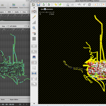
Check out this use of OSM data to make music. They map longitude to time and latitude to pitch with some city data. Or you can play it directly from this post as below:
We’ve built the £800 necessary for the purchase of the openstreetmaps.org domain name, so thanks to all who donated!
Yes, it’s true:

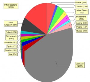
Have a look at this PDF showing where people edited (not where they live!) over an 8 week period. Germany leads the way!
I’m SUPER excited about the Atlanta Mapathon being held this weekend. Not because I care about Atlanta all that much even though my in-laws are from Atlanta. No, because I suspect that a huge mapping party, like a code sprint, is the most efficient way to get an entire city mapped. There are only 30 big cities in the USA. If we can withstand the surge of new OSM mappers, and we have enough experienced mappers to be able to scale the process, we can get an (open) street map of the USA finished within a year.
Probably not necessary to explain why it’s so important to have it be open. Probably is necessary to explain why the public domain doesn’t suffice. There are maps of the US already, produced by the USGS, in the public domain. The trouble with the public domain is that it’s not enough. You need a community who cares enough about the data to keep it up to date.
I’m a board member of the Open Source Initiative. We spend a lot of time dealing with licenses, to ensure that the code is “free enough”. We actually have a definition of “free enough”, which is the Open Source Definition. But free isn’t enough by itself. We have over a decade of experience, all of which tells us that free isn’t enough. Free software, or free data, or public domain data, isn’t sufficient. You need an open community of contributors.
And hopefully this weekend’s Mapathon will jumpstart that community within and without Atlanta!
Check out this mp3 of a quick CNN radio segment about OSM. This went out to some number of hundreds of affiliate stations across the USA today. Woo!
Thanks to some great work by Grant Slater and Andy Robinson all those people who mistake openstreetmap for openstreetmaps will now get directed to the right place.
But here’s the downside – we snapped up the domain to avoid the price going up and now we have to cover the costs of it. So make sure you feel good about yourself today by donating something toward the £800 that was needed over here on the donation site! Already about 10% has been found, so help out 🙂
Ever since OpenStreetMap started to receive interest and publicity its been regularly misquoted in the plural form, OpenStreetMapS. Now thanks to some diligent work by Grant Slater we are the proud owner of the openstreetmaps.org domain. No more will folks around the globe be able to google it badly.
Unfortunately getting the domain wasn’t cheap, in fact we had planned to run a donate drive to cover the cost before purchasing it, but such is our popularity we were concerned that the price might rise, so we’ve nipped in quick and secured it at the original offer price and now its ours.
Alas though the Foundation is now out of pocket by $1300 / £800. Please make a donation to help us raise this to replenish the coffers for when the next opportunity arises.