Monthly Archives: October 2009

Californian county fined for not releasing data

Nice wired article:

A California county’s three-year battle to prevent a nonprofit group from obtaining public mapping data has ended disastrously for the county after it was ordered by a court to pay the group $500,000 in legal costs.

Last February, Santa Clara County, the heart of California’s Silicon Valley, was ordered to hand over the public records to the California First Amendment Coalition for a minimal duplication fee after initially trying to charge $250,000 for the data and then appealing to the federal government to designate the data a national security secret that couldn’t be released. This week the county paid out to the coalition twice the amount in legal fees that it had once hoped to rake in as profit for the data.

BBC Article on OSM!

The BBC news website has a popular story on OSM over here. Money quote:

Atlanta, the capital of the US state of Georgia will soon be the world’s most digitally mapped city, according to organisers of a massive “mapathon”.
OpenStreetMap, or OSM, is behind the effort to produce a map more accurate than anything else on the market.

The story has been in the top shared box (look on the right) for most of the day. Awesome!

Podcast: James Fee & Peter Batty discussing the Google Data earthquake

Check out this podcast where James Fee, Peter Batty and I talk about the recent Google non-announcement that they’ve displaced TeleAtlas in the US with their own data. Both James and Peter have written about this in their own blog posts here (over 130 comments!) and here respectively. Enjoy.

Remember you can subscribe to the opengeodata podcasts with the links on the right.

Google bids fare-thee-well to TA in the US of A

Google says up yours farewell to TeleAtlas in the US, see this blog post. Europe has to be next what with the unknown (wink wink) patron which caused the AND share price jump (press release).

I’m sure Google will now want to release this data due to popular support given their own want to know “… why do they [Transport for London] make it so difficult to license their schedule data..” (link) and thus the clear problems surrounding closed map data.

So have a click around on Google Maps and see what it’s like to have (c) Google at the bottom right instead of (c) TeleAtlas 🙂

update Lots of comments on a post by James Fee

Google didn’t pay shit for this crap. They roll into city/county with “free” google earth pro licenses and the city/county gives them everything for free.

Happened to us and I know someone out on the left coast who had the same sales pitch.

Which sounds eerily familiar to the way they hoovered up transit data to the exclusion of others. Also see a post by Peter Batty

Cheap streetview

1238261

Check out this wired article

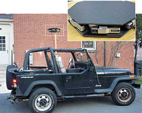
Using eight cheap webcams, a GPS receiver and open-source software, West Point graduate Roy D. Ragsdale built a rig that can do what Google’s Street-View cars do: take images of the world around it and stitch them together into panoramas. The difference? This version can be carried on your head and cost just $300 to make. The hacked-together software suite can even throw out files that can be viewed in Google Earth.