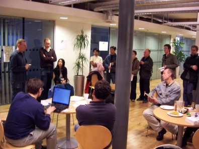
By the end of the first day of mapping in Victoria, Canada, we’ve covered a fair swath of the city:
There’s more to come tomorrow, and Monday, so come along and join in the mapping fun.
By the end of the first day of mapping in Victoria, Canada, we’ve covered a fair swath of the city:
There’s more to come tomorrow, and Monday, so come along and join in the mapping fun.
by Nick Black
OpenStreetMap is coming to Victoria, Canada. There’s going to be a load of OSM related activities in the city that boasts Canada’s mildest winter temperatures.
| OpenStreetMap Mapping Party | Sat 22nd – Mon 24th September |
| OSM mapping around the conference area | Monday 24th September |
| OSM talk at FOSS4G | Tuesday 25th September |
| OSM demo session | Wednesday 26th September |
| Post FOSS4G Code Sprint | Friday 28th September |
So if you are in the area, come along and join in the mapping fun. The usual stuff applies – its open to anyone, we have GPS units, its fun, sign up here
Its been a little while… Holidays and all that, but at least a tiny bit of Portugal is now mapped, and I’ve found out conclusively that my kids don’t find it amusing anymore to drive twice round a roundabout!
The Essen developers Workshop has been and gone (it has been a while!). A great weekend by the sound of it – pick up the results here – and if you wondered what happened to the code in subversion, a big restructuring (for the better!) happened. The code’s still there, but more logically laid out. It will be interesting to see what will come out of the UK workshop in Oxford next weekend.
Its been a good week for the osmarender layer on coastlines, again brought up at the Essen workshop. The threads Blue sea tiles, speckled oceans, & too much blue give an indication. So, thanks to Frederick’s work on a pre-processor to handle colouring of coastline tiles the coast is looking rather spiffing. Its great that (I guess) everyone who lives near the coast or had an interest in a bit of coastline made sure the coastline ways were fixed for their area (I know I did!). In fact its been such a good week for osmarender that there was a suggestion to create a separate osmarender-dev mailing list for it!
With a nod to Shakespeare, the thread titled: Users, contributors and developers, (… I come to bury columns; not to praise them) is worth a read in that it covers some of the ethos of OSM and how the simple approach to mapping is working very well. It then goes on to discuss the idea of a ‘third column’ to give namespaces to attributes that was brought up at the Essen workshop.
Watch out for The Rails Port of the server/API coming to a machine near you real soon! Announced by Nick Black on dev. This is going to have a big impact on OSM pretty quickly as its going to make it much easier for the devvers to tinker quickly in a safe environment.
Everyone loves animations!?! Dave has been making snapshots of progress on London over the last 6 months. You’ll have to follow the link to go to the animation.
Placenames disappearing! Its been discussed for a while, but David Earl noticed as you zoom in the slippy map that different names appear and disappear. Its a general problem with what to render at different levels, but it is an interesting discussion on what should be rendered at what level, and what should be considered important for rendering.
Languages for streetnames… The thread on Bilingual street names is a useful discussion on how to tag streets where there are two languages spoken, particularly where in some regions one of the languages is rarely used (we are talking parts of Wales here). Surprised there were no comments about Canada….
If you are one of the out-on-the road mapping types its frustrating to have to stop/start to make notes of a road, the streetname or whatever, so if you have a PDA running windows mobile, you might want to look at the thread on Audio mapping with a PDA and the wiki page that came out of it here.
Maplint I guess is the first really specialised map, but dare I say it, rather geeky! But – hey – that’s what its all about – very specific maps for specific purposes. Now with better cycle-specific tagging being discussed at Cycle route planning using OSM we will soon be getting really personal maps for cyclists. This is what OSM is all about, really personal maps.
And finally, if you want to spread the word on OSM look no further than Andrew’s question on presentation materials – its all there, including a lovely map by Steve Chilton. So there are no excuses now – go forth and promote!
by Barry Crabtree.
Well, when I say quiet, I mean the discussions were focused pretty well on a few topics..
The thing that caused most discussion this week was was about using the Yahoo! imagery in JOSM. Looks like it was a just-over-the-edge case for the license, so OSMers have stepped back from the edge while it’s use is clarified, puzzled on exactly what is the edge, and meanwhile continue to use it in the applet. It’s also prompted some healthy discussion on other sources of imagery from renting time on a satellite, to finding friendly pilots. (this paragraph might qualify for the ‘understatement of the month’ award!).
An exciting development on licensing was posted by SteveC – Queensland, Australia is/are? considering creative commons licensing for geodata! Read the thread for details! Richard Fairhurst has given a number of useful pointers.
The improving look of coastlines has been under discussion started by David Groom. People are keen to make them look good & there has been discussion on how to make this happen – having the coastline as one long ‘way’ is a bit of an issue, so other approaches are being discussed.
Superways were brought up again by David Earl (its a fairly regular thing…). The issue is about having a higher level structure above the ‘way’ structure. A ‘way’ represents a single stretch of road (or area) whose properties are all the same. This poses a problem when a road crosses a bridge (for example), as the part of the road over the bridge has to be represented as a separate way to be able to tag it as ‘bridge=yes’. Although its not a problem as such, there is no agreed method method to group these elements together to say ‘look, we know all these bits of road have different attributes, but really they are all the same road!’. There is inertia to move forward on this because of the changes that will need to be made to many areas in OSM (the editors, the database, theXML, and not least agreeing what ‘ superways’ give!). Hidden in the discussion were some juicy tips on JOSM – there is a lot of functionality in JOSM that’s not readily apparent. You can find out much information on way segments with the correct vulcan death grip on the keyboard!
On Dev Jochan Topf has reminded that there’s a developers workshop being held in Essen, Germany in a couple of weeks. If you ‘d like to join in, add your name here. It also looks like there might be a UK dev workshop, but nothings been firmed up yet.
Its good to see the newbies list is active. Don’t be shy – feel free to ask questions. You’ll be sure to get a friendly response.
Now, how did the Sheffield mapping party go?
by Barry Crabtree.
Thanks to Mikel and generous donations, we now have GPS units for use at mapping workshops! W00t!

This weekend! There’s a pre-event podcast with mikel too.
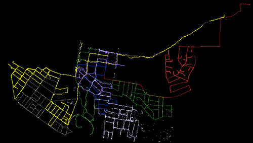
After the first day of mapping in Bath, we’ve covered quite a lot of ground. Here is a screenshot from JOSM, showing what we’ve done after the first day.
After day two most of the central streets had been covered. Join in the fun and come along to the next mapping party.

 This weekend openstreetmap comes to Bath for a Bath Mapping Party. Yes, we’ll have another place mapped in a weekend! Get your hands on the press release and have a look at more upcoming mapping parties in your area.