Author Archives: Steve Coast

Mappedchester


Yes, mapchester is over. We met at the MDDA and through various bits of insane publicity attracted 40-odd people over the weekend who came to help map manchester. The end result will be used at futuresonic.
It was a somewhat different event to the Isle of Wight, not attracting so many people versed in licenses and GPS signal properties. In fact, most had never used a GPS unit before. Speaking of GPS units, eTrex devices didn’t fare too well in Manchester’s urban areas thanks to the urban canyon effect. We all need 60CSX units but they’re expensive. Much like we all need houses in the Caribbean.

Great Quote

Etienne Cherdlu makes an interesting couple of perhaps tounge-in-cheek points against what the OS recently told The Guardian.

>From Thursday’s Guardian article:
“We make an average of 5,000 changes to our large-scale data every day,” said an OS spokesperson. “It’s not about mapping the Isle of Wight once – it’s about continuing to map it … It is expensive to collect detailed, accurate information on the ever-changing world to the level of detail our customers require.”

>From an OSM spokesperson:
“This month we made an average of 6,567 (Note 1) changes to our large scale-data every work day” said an OSM spokesperson. “It’s not about mapping the Isle of Wight once – it’s about continuing to map it … and using enthusiastic and passionate volunteer surveyors we are collecting more information every day with 1,864 registered volunteers than the Ordnance Survey manages to do with a paid full time workforce of 1,490.”

LinuxTAG

One of the best things about openstreetmap is that I havn’t got a clue what everyone does any more. Once upon a time I knew everyone involved but now with over 1800 users things are just too big. Sxpert put an underground OSM demo at the X.org stand at LinuxTAG, you can see pictures here. I wonder if Matt realised his logo would show up all over the place. The tag line is very nice ‘free map data for a free world’.

Ticket to Ryde


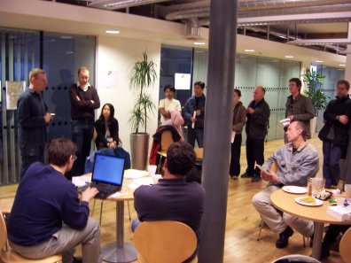
The Isle of Wight workshop is now over and most of us have travelled back nursing sores from punching those tiny GPS buttons all day. It was a great success, with over 30 people turning up. Friday started for David Groom and I by doing an interview for solent tv which can be downloaded here. The main event started with an extended BBQ on the beach on Friday night as people arrived with food, beer and parsnip crisps Stone Soup style. This carried on late in to the night and involved building a bonfire out of drift wood, getting carried away and trying to cook bananas.

Retreating to caravans and cottages, the next day was planned over donuts. We met in the morning at the Riverside Center in Newport and roughly divided up the Isle in to parts for people to map with much self-organisation. Everyone departed on foot, by car or cycling with GPS and methods of noting features like streets – camera, notebook or dictaphone. Those at HQ changed camp to the Quay Arts Center which provided much needed wifi.

SA Mathieson came to talk to us for (hopefully) a piece in this Thursday’s Guardian. The MP for the Isle of Wight, Andrew Turner, came and saw what we were doing. Being an ex-geography teacher he was interested, and the local press came along to snap some pictures too.

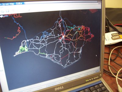
Sunday began by collating all the tracks together and deciding where next to map. The picture shows what we had, and it was impressive for one days work. Based on this, people departed to continue mapping but most came back for a late lunch together before sailing home.

But the best is yet to come! The traces will now be turned in to animations, posters and of course, a map!

Weighted Car

This is a pic of Nick Hill’s car after being loaded with servers, rack cabinets and stuff. It took hours of work, and Nick drilled out some rivets to take the cabinet apart. Currently we’re waiting on the official green light on hosting, at which point all this stuff will get installed.

Podcast: Nick Hill

Nick and I spent a day tearing apart donated computers and racks last week and afterward ended up in a pub. We talked about openstreetmap and how he’s getting data in there. Here is an 11 meg mp3 which lasts 25 minutes. Again, if you subscribe to the RSS feed in iTunes etc then you’ll magically get the audio in your iPod. Enjoy!

Our first spam

Openstreetmap had its first spam yesterday from someone uploading a html file (a web page) as a GPX file (a GPS trace file). Being XML (similar format), it got parsed and uploaded with spam-like tags linking to the individuals business. The point being that google etc would crawl the pages and increase his page rank. It exposes the soft underbelly of openstreetmap’s policy of crossing bridges when we get to them – we’ve only had good bridges so far!