Hat tip to OSM contributor, Pascal.

OpenStreetMap has *now* 300.000 Members ! #OSM http://www.openstreetmap.org/stats/data_stats.html
— Pascal Neis (@pascal_n) September 11, 2010
http://www.openstreetmap.org/stats/data_stats.html
Hat tip to OSM contributor, Pascal.
OpenStreetMap has *now* 300.000 Members ! #OSM http://www.openstreetmap.org/stats/data_stats.html
— Pascal Neis (@pascal_n) September 11, 2010
http://www.openstreetmap.org/stats/data_stats.html
Adam DuVander reviews mapping APIs and asks the question, Whatever
happened to the person who made that Chicago Crime mashup?
Get the answer to this compelling question, and more in Adam’s article.
http://radar.oreilly.com/2010/09/the-state-of-mapping-apis-five.html
Image of the Week was started four years ago, this week, by
OpenStreetMap contributor OJW.
http://wiki.openstreetmap.org/wiki/User:Ojw
This rendering of Chester was the first image of the week on 02
September 2006.

Since then, Oliver has selected the best images by, for and of the OSM
community, every week and has shown us renderings, contributors,
hardware, animations, products, and more contributors.


Thanks, OJW!
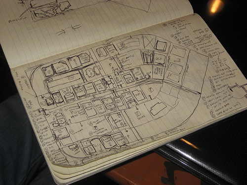
This is the survey log book of OpenStreetMap user seav and
demonstrates that great mapping can be done with a keen eye, a steady
hand and little in the way of high technology. Until you are ready to
edit and upload.
This page of the log book shows this area of the map.
http://www.openstreetmap.org/?lat=14.5875&lon=121.06185&zoom=17&layers=B000FTF
The photo was taken by OSM user maning, during the Ortigas-Mandaluyong
Mapping Party.
http://wiki.openstreetmap.org/wiki/Ortigas-Mandaluyong_Mapping_Party
Log book photo by OSM user maning http://wiki.openstreetmap.org/wiki/User:Maning
is licensed CC-By-SA http://creativecommons.org/licenses/by-sa/3.0/
This is a Featured image, which means that it has been identified as
one of the best examples of OpenStreetMap mapping, or that it provides
a useful illustration of the OpenStreetMap project.
If you know another image of similar quality, you can nominate it on
http://wiki.openstreetmap.org/wiki/Featured_image_proposals

OpenStreetMap contributor Kate Chapman had a question on her mind and
an instinctual answer. Then she looked in to the numbers to find out
what they said.
There is no question the collaboration of the
OpenStreetMap community in the month following the earthquake in Haiti
was amazing. People from all over the world traced satellite imagery
and imported data to create comprehensive street data for
Port-au-Prince and the rest of the earthquake affected parts of the
country. After reading this Ethan Zuckerman blog post, I wanted to do
some analysis of who exactly made the map. Was it primarily the
already existing OpenStreetMap community? Or was it those who didn’t
want to just text message their ten dollars and actually wanted to do
something to help and OpenStreetMap became a venue for that? This new
group would mostly individuals coming from CrisisCommons during the
many CrisisCamps that occurred during this time. I’ve always stated
that it was the already existing OpenStreetMap community that did the
majority of the map, but I was going on gut instinct, not actual
statistics and facts.
Read the rest of Kate’s analysis, and find out which OSM user was
first to contribute improvements to the Port au Prince map after the
earthquake on her blog.

The humble postbox. Some might argue that postboxes are less
important in a world of email, cell phones and instant messaging.
Some cities are removing postboxes that are seldom used and finding a
cost savings.
http://www.cbc.ca/canada/nova-scotia/story/2010/04/20/ns-mailboxes-canada-pos…
Some would argue that the decline of the postbox means that a postbox
is beneath the notice of a modern, on-line, Web 2.0, open data
project.
And others argue that the decline of the postbox is exactly why
OpenStreetMap contributors care about postboxes; those looking for a
postbox must look further afield to find one.
Learn how to add postboxes and other things that interest you in the
Project of the Week.
http://wiki.openstreetmap.org/wiki/Project_of_the_week/2010/Sep_05
Gregory Marler is an OpenStreetMap contributor who cares about
postboxes and he has provided us with this Project of the Week.
Gregory tells us about finding his OpenStreetMap obsession with
OpenStreetMap and postboxes on his blog.
http://www.livingwithdragons.com/2009/06/my-postbox-obsession
This is your Project of the Week. Make suggestions. Inspire other
mappers. What is it about contributing to OpenStreetMap that
interests you? Postboxes? Bowing alleys? Share your OpenStreetMap
obession by contributing a Project of the Week.
http://wiki.openstreetmap.org/wiki/Project_of_the_week/Proposals
Other Projects of the Week / Humanitarian Mapping
Humanitarian emergencies continue. If you can provide some additional
remote mapping time please consider helping.
http://wiki.openstreetmap.org/wiki/2010_07_Pakistan_Floods
http://wiki.openstreetmap.org/wiki/Project_of_the_week/2010/Aug_15
Postbox photo by Frankie Roberto.

Antony Pegg announces on the MapQuest Developers Blog that they have
launched an open directions service on OpenStreetMap data.
A couple of Antony’s highlights are:
– This service is powered completely by free, open-source
OpenStreetMap data, instead of commercial data.
– You do not need a key. To repeat: NO KEY. NO SIGNUP REQUIRED. NO
NEED TO AUTHENTICATE – just go use it.
But you should go read the full article
http://devblog.mapquest.com/2010/08/31/mapquest-directions-service-on-openstr…

Participantes en la reunión de openstreetmap el Jueves 12 de agosto de
2010 en el CIDA, Mérida – Venezuela
Participants at the OpenStreetMap meeting in Mérida, Venezuela on 12
August 2010.
This is a Featured image, which means that it has been identified as
one of the best examples of OpenStreetMap mapping, or that it provides
a useful illustration of the OpenStreetMap project.
If you know another image of similar quality, you can nominate it on
http://wiki.openstreetmap.org/wiki/Featured_image_proposals
Photo by OSM contributor Hernan Ramirez
http://wiki.openstreetmap.org/wiki/User:HernanRamirez

One of the most frustrating things about navigating a vehicle through
urban areas are turn restrictions. You want to go right but the sign
says you must go left. Some of the frustration is caused by the
additional driving time and increased number if turns required, but
that frustration is compounded if you didn’t know that the turn
restriction existed in the first place.
With well mapped turn restrictions, you can plan a better route right
from the start, rather than adapting later. The project of the week
is to check and update turn restrictions in your area.
Find out more about checking, adding and fixing turn restrictions,
including tutorials on the OpenStreetMap wiki page for this Project of
the Week.
http://wiki.openstreetmap.org/wiki/Project_of_the_week/2010/Aug_29
This is your Project of the Week. Make suggestions. Inspire other mappers.
http://wiki.openstreetmap.org/wiki/Project_of_the_week/Proposals
No Right Turn photo by TheTruthAbout http://www.flickr.com/photos/thetruthabout/
licensed cc-by-sa http://creativecommons.org/licenses/by-sa/2.0/deed.en_CA
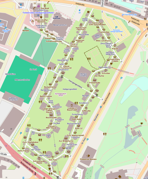
Hamburg has a large carnival three times a year for each 4 weeks. User
mbuege maps all the attractions and fast food stands.

This is a Featured image, which means that it has been identified as
one of the best examples of OpenStreetMap mapping, or that it provides
a useful illustration of the OpenStreetMap project.
If you know another image of similar quality, you can nominate it on
http://wiki.openstreetmap.org/wiki/Featured_image_proposals