Monthly Archives: April 2013

OpenStreetMap opens up to more contributors with easy ‘add a note’ feature

OpenStreetMap, the collaborative map of the world often called “the Wikipedia of mapping”, has unveiled a new feature designed to make it even easier to contribute.

For the first time, anyone viewing the map can suggest a correction – such as a renamed business, a missing footpath, or a changed road layout – without learning to use map editor software.

notes screenshot

The corrections will be picked up by OpenStreetMap’s million-strong army of volunteer mappers. A local mapper can visit the location to check the suggested information, and then update the map.

OpenStreetMap’s data is used by some of the biggest mapping names on the web, including Foursquare, Craigslist, Wikipedia, Mapquest, and Apple’s iOS Maps app. It is also extensively used in humanitarian operations, most famously after the Haiti earthquake of 2010.

The new feature is part of a drive to open up OpenStreetMap contributions to more people – so that everyone can add their local knowledge to the map. Later this spring, an all-new HTML5 map editor will be coming to openstreetmap.org; its intuitive controls and clear walk-throughs will encourage more map users to take the plunge and become map editors.

“It’s the detailed local knowledge of our contributors that makes OpenStreetMap so much in demand from web and app developers,” explained Simon Poole, Chairman of the non-profit OpenStreetMap Foundation and a Switzerland-based mapper himself.

“By making it even easier to add to the map, we’re increasing the amount of on-the-ground knowledge we can capture – further distancing OSM from the traditional map data companies and their lack of local expertise.”

To add a note or correction to OpenStreetMap, find your area on openstreetmap.org and click ‘Add a note’ in the bottom right corner.

Background information

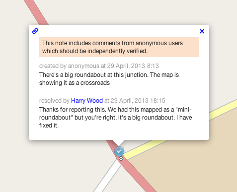
Notes are freeform natural text, read by other people, making this is a very simple way to communicate any problems we notice about the map without needing to get to grips with OpenStreetMap and its tagging system. Although this functionality has been available for a while on the third party site OpenStreetBugs, adding it to the main OpenStreetMap site brings it to a much greater audience.

Although it is not necessary to have an OSM account to create a note or comment on it, registered users can see all the notes they have created or commented on, and will receive automatic email notifications if the status of a note changes. OpenStreetMap’s enthusiastic community is its greatest strength, and these notifications facilitate an exchange between the original reporter and experienced mappers.

A full API is available for the notes so that third party sites or apps can query existing notes, create and comment on them – opening up possibilities for mobile bug reporting and fixing. The system is expressly designed for high-quality reports from individual users, not automated error checks or ‘bots’.

OpenStreetMap takes copyright very seriously. Registered users agree not to copy from other maps when signing up, and are requested to verify each suggested correction from non-registered users using ‘on the ground’ information. OpenStreetMap is a map for the people, by the people, and made with personal local knowledge.

Further details are available on the OpenStreetMap community wiki.

Weekly OSM Summary #67

April 8th, 2013 – April 22nd, 2013
A summary of all the things happening in the OpenStreetMap world.

  • Follow Live Edits made to the OpenStreetMap database. And a second webpage with a similar visualization.
  • A new update to the RFC OSM attribution mark.
  • The TOP 50 Mappers of the United States will get a ticket discount of 50% for the upcoming State of the Map US in San Francisco. Read more here.
  • The released GPX Planet dump visualized as a transparent overlay, created by Ilya Zverev.
  • The Overpass Turbo tool now supports MapCSS.
  • A blog article by Young Hahn about „Hack Your Maps
  • A blog article about Kite-Mapping
  • Using fieldpapers in the OSM editor JOSM.
  • Using R to analyze OSM data. A diary entry by Hawkeye.
  • A blog post about the latest HOT activities in Africa. Also, HOT started a new project after the earthquake in Lushan (China). The summaries of the HOT board meetings are online here too.
  • The open source tool Mapwarper helps you to rectify your old and new maps.
  • A new OSM renderer called alaCarte is available at github.
  • A research study about the impact of mapping parties in London.
  • Ten fascinating facts about OSM United Kingdom & OSGB.
  • Celebrate National Park Week with Chimani’s OSM based app for outdoor activities.
  • The next Wherecamp Berlin will be between June 21st and 22nd, 2013.

Authors: Pascal & Dennis – (thx @ “Wochennotiz”)

State of the Map – Call for Papers

The call for papers for State of the Map-Birmingham is now open.

Rob Nickerson, of the State of the Map organizing committee, sends the following information for you.

It’s that time of year again when we look to you, the mind-bogglingly creative OpenStreetMap community, to tell us what you’ve been up to. That’s right – it time to submit your presentation ideas for the annual State of the Map conference.

Presentations

State of the Map 2013, to be held in Birmingham, United Kingdom, from 6 to 8 September is calling for presentations.

The theme of this year’s conference is “Change” so we are particularly interested in presentations addressing this theme. Our programme will cover a wide range of topics that will interest everyone from the new OpenStreetMap contributor to the old hand to the professional contemplating using our data.

If you have something interesting to present about your work with OpenStreetMap and would like to tell the world, we would love to hear about it. Simply fill out the Call for Presentations form explaining the topic of your presentation. To keep things easy, at this stage we just need a few words, not a full presentation. 🙂

Who can present?

We are seeking presentations from businesses, the public sector, charities, and individuals.

Poster Exhibition

This year I personally want to try and get as many people involved as possible. We are therefore hoping to have a Poster Exhibition for people who may not be able to attend in person (we can print them locally). If this sounds interesting to you, please use the same form and specify “Poster” as the “Session Format”. Posters can be mainly pictorial, or include text. You can bring it yourself or send an electronic copy for local printing

Sponsor the poster exhibition

Sponsorship to cover printing costs would be much appreciated.

If you have something to say, for example, about switching to OSM, barriers to its use, apps for mobile mapping, changing community organisation or behaviour, historical mapping, or just anything that you want to present, then make sure you register your proposal with a a few words to describe the topic.

Tutorials

Tutorial sessions are especially welcome!

Deadline

Call for Presentations closes on Monday, 10 June 2013.

About State of the Map

The State of the Map is the official, annual, international, OpenStreetMap conference. Founded in 2007, previous State of the Map conferences were held in Manchester, Limerick, Amsterdam, Girona, Denver and Tokyo.

Weekly OSM Summary #66

March 25th, 2013 – April 8th, 2013

A summary of all the things happening in the OpenStreetMap (OSM) world.

  • The new OSM iD editor reached version Beta 1. You can also find some slides by John Firebaugh that include some background information of iD here.
  • Is someone interested in taking over the OSM editor Merkaartor? Read more here.
  • A first initial dump of all OSM GPX tracks is downloadable now. You can find additional information in the following thread.
  • Frederik Ramm wrote an article about his work at the OSM Foundation Data Working Group.
  • The OSM Inspector Routing View is now available for the whole world as a single layer.
  • A Youtube video about the “ViaAlpin” mapping party.
  • A new mailing list has been created for discussions and questions about tile-serving.
  • The rendering of the OSM France tile server has a neat visualization for soccer and golf fields.
  • Simon Poole’s QA Map service has a new layer. It can highlight way objects with and without name or address-tags.
  • Matthias created a video about the integration of OSM data into SuperTuxKart game.
  • Some notes from the latest HOT meetings and an update on Kunduz mapping.
  • The website formally known as http://www.pistes-nordiques.org , is now available at: http://www.opensnowmap.org . You can find some additional information here.
  • Several US users had some issues using the Overpass-API. This has been fixed now.
  • How to use OSM map tiles from Stamen or MapBox as basemaps in ArcGIS.com.

Did we miss something? You can contact us via weekly.osm@googlemail.com

Authors: Pascal & Dennis – (thx @ “Wochennotiz”)

Bulk GPX track data

Last year, at about this time, the OpenStreetMap Foundation made a big splash when it released the first Bulk GPS Point dataset. That may have been the largest publication of GPS point data ever. Many users were thrilled to have that raw data and to put it to good use. But they also wanted more. They wanted the track file details.

In fact, requests for bulk OpenStreetMap GPX track files go back to 2007 or earlier. Now, the combined talents of the OpenStreetMap community and the resources of the OpenStreetMap Foundation, make that dream a reality.

Announcing the GPX Planet

The scale of this dataset is fairly large.

  • 848,000 GPX files
  • 2.6 Trillion GPX points
  • 260GB of GPS data (uncompressed)

Not everybody will be able to manage all of this data at once. It is likely, as with planet files and planet extracts, that somebody will offer GPX extracts.

What is this data good for?

Well, it’s interesting and there is a large quantity of it. Many OpenStreetMap contributors have been asking for it for years. Previous uses for this type of data have included

  • artistic organic trip data as maps
  • confirm turn restrictions
  • confirm one-way restrictions
  • confirm speed limits
  • and many more of your ideas in the comments

The future

There are hopes and plans to improve this service over time, including

  • quarterly updates
  • addition of vdop / hdop precision data, where available

You can help

You can help to improve this service by contributing your GPX track data. Upload your GPX files through your OpenStreetMap account. Collect new track files as you survey.

You can also help by using the data for something interesting and / or by publishing some code. OpenStreetMap user Zverik has started the ball rolling by creating gpx2pgsql to put the gpx data into your rendering tool chain.

Thanks

Thanks as always to the million-plus OpenStreetMap contributors over the eight years of the project so far. Especially, thanks to the thousands of contributors who collected and uploaded their GPX track files, and to Lars Franke, who wrote the first Java GPX dump code in 2010, and to Ian Dees who rewrote that into the current Python code, and to the many others who were involved in ways large and small.

So, where is it?

Find the GPX planet on the planet site and mirrors.

The image in this article is a visualization of some of the GPS point data in Europe. The image is licensed CC-By-SA and was created by Dave Stubbs.