I often get requests about the growth and competitiveness of OpenStreetMap in regards to commercial maps. While OpenStreetMap excels especially when it comes to details, people want to see figures that are more comparable to the commercial maps – mainly navigatable road networks.
I came across some internal evaluations of the recent planet files and thought I just share those figures figures with. These statistics are Europe related and show the values separated for Western and Eastern Europe.
In general we can report a healthy growth over the last 9 months – despite the license change that caused some loss of data.
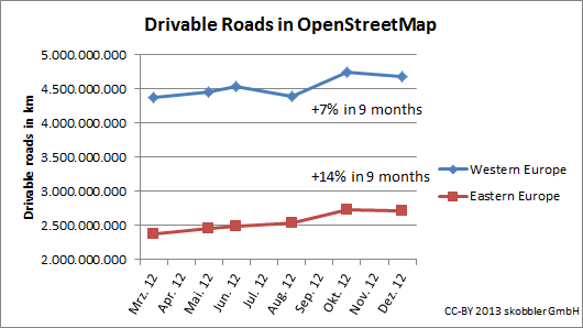
The drivable road network continues to grow in Western and Eastern Europe. While some countries like Germany have more or less reached 100% coverage of the driveable road network, others still have potential. In Eastern Europe I want to stress the growth of Turkey by 39% and Russia by 19%. In Western Europe we see Spain growing by 18% and France by 19%.
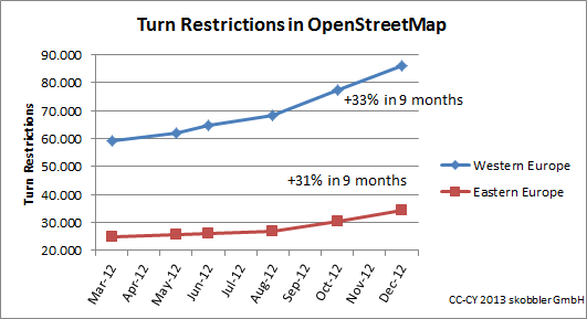
Turn restrictions show a strong growth – Eastern and Western Europe alike. Saturation has not been reached in any country –even Germany has grown by 34%.
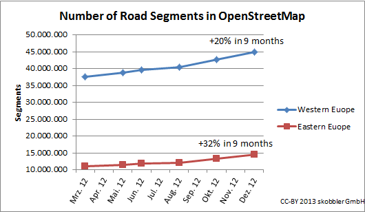
The overall growth of road segments shows an uptake after the license change had been completed.
Overall we see stronger growth in Eastern Europe, which means the gap between Eastern and Western Europe is narrowing.
This is showing just an extract of available data but allows extrapolation with a good confidence level. If you have questions don’t hesitate to contact me.


I’m confused the Skobbler claims copyright on the charts. First this is graphics are results of processed ODbL material, which results in copyleft? Second, this is bad karma in a open community that Skobbler says you are part of? Third, this prohibits to make use of this stats to promote OSM?So, why did you release it with copyright?
To previous comment, it’s nor a copyright but a copy-left used in charts. saying you can use it even for commercial purpose as long as you say who did charts. (I suppose the third graph have a typo, you probably have to read CC-BY instead of CC-CY)
Do you accept requests to generate the same statistics for a specific country (Brazil), please?
I agree with !i!,maybe you should write such kind of blog posts on your company’s webpage next time?
Come on, Oliver fixed the attribution, so everything is ok. My critic wasn’t about the use of OGD.org blog in general.Thanks for fixing!
nice stats – but you mentioned per country stats. where could we see them ?also, what does west/east include ?
What do you class as drivable roads in OSM?Some who comply data I have seen don’t include unclassified tagged roads when they are valid and teh correct terminology (despite the slightly stupid sounding definition)Do you include Unclassified roads (Minor in Potlatch editor)?What about service roads, parking aisles, tracks, etc?