Monthly Archives: December 2012

Introducing OpenStreetMap’s JavaScript editor – alpha version

Screen_shot_2012-12-22_at_10

Back in July I wrote about building a new, friendly map editor for OpenStreetMap in JavaScript. Since then, and in particular in the last two months, the project has come on in leaps and bounds – and today marks the first alpha release.

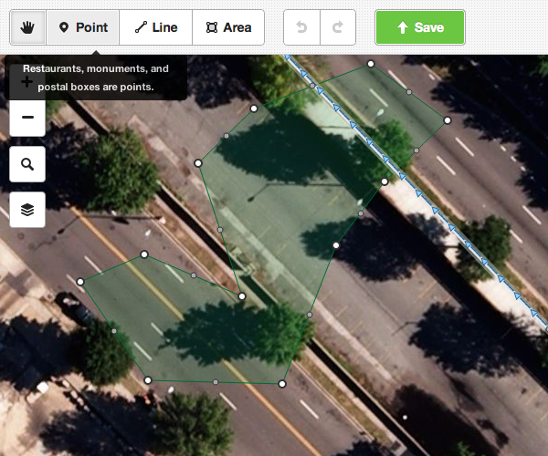
Codenamed iD, it aims to provide an easy-to-use, comfortable editing environment for the OpenStreetMap newcomer that’s nonetheless fully featured – you’ll be able to edit any OSM data with it. Clear modes such as “Move map” and “Add point” make it easy to get started without having to read swathes of instructions.

So – try it out! You can play with a working instance at geowiki.com/iD. It’s connected to a test database, not the main OpenStreetMap database, so don’t worry – you won’t break anything.

If you find a bug, use github to check it’s not already been reported, and file one if not.

The fast progress over the past few months is entirely down to the work of Tom MacWright and Saman Bemel Benrud, John Firebaugh, and others. Some of them have been funded to work on this by a Knight Foundation grant from the Knight News Challenge programme.

As ever with OpenStreetMap, the code is fully open source, and we’re looking forward to the community getting involved with helping to build the project. For the first time since OSM was founded in 2004, this will give us a full suite of editing tools – iD and mobile tools for new users, Potlatch 2 and Merkaartor for intermediate editing, and JOSM for power users – so that anyone can bring their local knowledge to the map, whatever their expertise.

Read more about the alpha release in Tom’s blog post.

Weekly OSM Summary #58

December 2nd, 2012 – December 16th, 2012

A summary of all the things happening in the OpenStreetMap (OSM) world.

  • Andy Allan re-implemented the standard OpenStreetMap mapnik style in CartoCSS.
  • A blog post about the first design phase of the new OSM editor ID and a demo version can be found here.
  • The Los Angeles Times contributes LAFD fire stations to OSM. Have a look at the OpenFireMap and read the article here.
  • All documents and slides of the “International Meeting of Crowdsource Mapping for Disaster Risk Management and Emergency Response” are online. You can read more about the event here.
  • Harry Wood wrote a blog post about the last London Hack-weekend. Great picture btw. Harry 😉 Harry’s XAPI URL Builder also supports the Overpass API now.
  • Mapbox launched a new satellite layer. You can find some additional information on how to use the new data for OSM tracing here.
  • The well-known OSM Importer for PostGIS: Imposm, now supports PostGIS 2.0.
  • A first version of “addressmerge” has been released. This tool allows to post-process address data by comparing it with existing OSM data.
  • A blog post by Frederik Ramm: Have you got your 1,000 house numbers already?
  • How to visualize London’s buildings with 3D mapping, a blog post by Tom Holderness.
  • OSM 3D buildings for your 3d glasses.
  • The Geofabrik added the timestamp to its well known OSM PBF extracts. Read more about the new information in the header of the files here.
  • Vizrt uses OSM to provide global street maps for broadcasters.

Did we miss something? You can contact us via weekly.osm@googlemail.com

Authors: Pascal & Dennis – (thx @ “Wochennotiz”)

New Tile Server in Pau, France

Thanks to generous donations and active members of the OpenStreetMap community, OpenStreetMap infrastructure continues to grow.

A new tile server, Lurien, has been added to the OSM tile cache network. Located in Pau, Pyrénées-Atlantiques, France, Lurien is currently serving tiles to IP addresses from France, Spain, Portugal, Andorra, Gibraltar, Italy, Monaco, San Marino and Vatican.

Lurien, highlighted.

Map tiles are delivered to users based on their GeoDNS location. The OpenStreetMap Foundation seeks additional distributed tile servers. If you would like to donate a tile server and hosting, please see the Tile CDN requirements page on the wiki.

We would like to thank PauLLA with support of UniversitĂ© de Pau et des Pays de l’Adour (UPPA) for the server and connectivity and CommunautĂ© d’AgglomĂ©ration de Pau PyrĂ©nĂ©es (CDAPP) for the data centre hosting. We would also like to thank OpenStreetMap contributor Christophe Merlet for arranging the donation.

The OpenStreetMap Foundation is a not-for-profit organization, formed in the UK to support the OpenStreetMap Project. It is dedicated to encouraging the growth, development and distribution of free geospatial data and to providing geospatial data for anyone to use and share. The OpenStreetMap Foundation owns and maintains the infrastructure of the OpenStreetMap project. You can support OpenStreetMap by donating to the OpenStreetMap Foundation.

International Volunteer Day

Today is International Volunteer Day. OpenStreetMap is all about volunteers of course. It’s about people getting out there and mapping their neighbourhood. If we have enough people volunteering in this way (just a little of your time, and local knowledge) we’ll have a free map of the world in no time!

But did you know OpenStreetMap is made up entirely of volunteers? Sometimes people assume that OpenStreetMap is a commercial company alongside other map providers, but OpenStreetMap is something different. It’s an internet-based collaborative project. Not only the mappers, but the entire organisation is built and driven by volunteers in their spare time.

The people who develop the website and the map editing software
…all volunteers.

The people who maintain the servers and keep the database and map view operating smoothly
…all volunteers.

The people in the working groups of the OpenStreetMap Foundation
…all volunteers.

The people on the OpenStreetMap Foundation board
…all volunteers.

We do occasionally discuss the idea of paying people in various roles of the foundation, but as it stands at the moment OpenStreetMap is an entirely volunteer-driven organisation from top to bottom. We’ve got where we are through the hard work and dedication of people who give up their spare time to the project. Hats off to the volunteers of OpenStreetMap, and a very happy International Volunteer Day!

Learn how to get involved

Weekly OSM Summary #57

November 19th, 2012 – December 2nd, 2012

A summary of all the things happening in the OpenStreetMap (OSM) world.

Did we miss something? You can contact us via weekly.osm@googlemail.com

Authors: Pascal & Dennis – (thx @ “Wochennotiz”)