Monthly Archives: April 2011

OpenStreetMap on Television

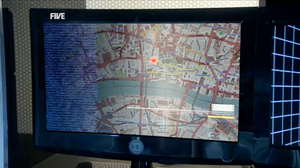
London OpenStreetMap in K9 episode The Bounty Hunter

[Updated 20 May 2011]

Above is an image of London, from the OpenStreetMap Mapnik rendering style, as it appeared in an episode of K9. K9 is a television series for 11 to 15 year-old children, produced by Stewart & Wall Entertainment.

As OpenStreetMap contributors, we enjoy seeing our collective map used by others. The nice folks at Stewart & Wall Entertainment wanted to do more for OpenStreetMap than just use the map in their TV program. They have also written a nice note on their web site, thanking us all for providing a cool map. You should read the note in their news section because it suggests something very cool for the future. And they have added a credit on the series information page, too.

Thanks, Stewart & Wall!

[ 20 May 2011 update ]

Stewart & Wall have added a “thanks” to OpenStreetMap on the company credits page for The Bounty Hunter on IMDB.

Geocaching beta map includes OpenStreetMap

It’s nice to see interesting projects using OpenStreetMap for
interesting things. Geocaching.com have a Beta map that allows
users to select OpenStreetMap mapnik tiles as one of many basemaps.
This is pretty cool. What’s even cooler is that we may be approaching
the point where OpenStreetMap and Geocaching start to make each other
noticeably better.

Geocaching and OpenStreetMap seem like a match made in a top of the
line GPSr. As a long time OpenStreetMap participant, it has always
seemed like a natural match. It seemed to me that Geocachers would
like OpenStreetMap. Why did it take me so long to try geocaching?
And what secret did I learn that Geocachers will want to know?

Learn the secret about OpenStreetMap that your Geocaching friends will want to know.

More cool tricks by the MapQuest Open team

The MapQuest Open team have done it again! Check out these cool tricks they’ve created for OSM fun:

API allows searching the OpenStreetMap (OSM) data by name=value pairs or bounding box! Very cool stuff if you’re trying to find all the golf courses in OSM data in the greater Denver area:http://open.mapquestapi.com/xapi/api/0.6/node%5Bamenity|leisure=golf_course%5D%5Bbbox=-105.20983780356221,39.59556488319815,-104.66052139733415,39.83325197240866%5D  

Here’s the link to the actual tool:  http://open.mapquestapi.com/xapi/ all GUI and pretty with an XML response. 

The Nominatim Pre-Indexed Data Service gives OSM developers another database location (hosted on the MapQuest servers) from which to download the large Planet OSM data file from – the beauty is that this data file is already indexed so you don’t have to waste any time indexing a 15GB+ file! Once a developer has Nominatim running on their local server, they can download, via the NPI Data Service, updates approximately every 5 minutes.

A recent quote from the Open team:“you can set Nominatim up on a fairly crappy machine as long as it has reasonable disks, because a single processor home computer can load it from NPI.” They’re all about keeping things easy for anyone wanting the latest and greatest geocode data from OSM! 

Lastly, they’ve created a Broken Polygon Report that anyone can use to help make OSM data better and more accurate via JOSM or Potlatch 2. Think of how you’ve been editing an area only to find a sizable chunk of map data that is just messed up and you have to correct that first, before finishing up your edit…arugh! Another example is when OSM had an issue last December where a broken polygon ended up having all of Virginia being shown in Maryland. A broken polygon can mean that any map area can get “flooded” by another, as one polygon’s fill bleeds into the other via that broken gap. This report allows folks to easily find these little (or big) errors and fix them!

You can read more about XAPI, NPI and the Broken Polygon tool on the DevBlog and click on the pretty hyperlinks here:http://devblog.mapquest.com/2011/04/07/xapi-npi-broken_polygons/ 

Big, huge, massive thanks go out to Matt Amos, Brian Quinion, Kumiko Yamazaki and Cameron Thomas for making this happen! 
Project of the Week: Groceries

Food month continues. The Project of the Month is farmers’ markets
where you can buy fresh food ingredients directly from the farmer.
This week we look at grocery stores, where we can get fresh food
ingredients but they might be from further away and from many vendors.

This week we look at fresh fruit and vegetables from shops large and
small. For smaller shops we have greengrocers, for larger we have
supermarkets.

For project of the Week add your local grocery stores to the map.

This is your Project of the Week. Make suggestions. Inspire other
mappers. What is it about contributing to OpenStreetMap that
interests you? Postboxes? Bowing alleys? Share your OpenStreetMap
interests by suggesting a Project of the Week or Project of the Month.

Greengrocer photo by artq55 is licensed CC-By-SA.

Potlatch 2 is here

OpenStreetMap editing just got faster, smarter and smoother! We’ve
done the switch-over to Potlatch version 2 on the ‘edit’ tab of
the OpenStreetMap homepage.
If you haven’t tried it already, click that ‘edit’ tab and get
mapping!

This represents a lot of development work by Richard Fairhurst, Andy Allan, randomjunk,
and others. The work really picked up pace recently, with everyone
pulling together, but Potlatch 2 has been in the pipeline for a couple
of years now. It doesn’t stop there of course, but it’s ready for
prime-time now, so we’ve made the switch. We hope you like it, but for
now you can still get back to the old potlatch by hovering your mouse
over the edit tab.

So what’s new in Potlatch 2?

  • User-friendly tagging with customisable presets
  • WYSIWYG rendering
  • Vector Background Layers
  • A more flexible undo/redo system
  • OAuth support so you can deploy it on other websites

Keyboard shortcuts and other aspects of general editing have largely
stayed the same

We’ll be working to update documentation and hopefully create some
nice new video tutorials etc (and anyone can help with these things)
but for now you can find out more on the Potlatch 2 wiki page and the Potlatch 2/Primer

Potlatch 2 is here

OpenStreetMap editing just got faster smarter and smoother! We’ve done the switch-over to Potlatch version 2 on the ‘edit’ tab of the OpenStreetMap homepage. If you haven’t tried it already, click that ‘edit’ tab and get mapping!

This represents a lot of development work by Richard Fairhurst, Andy Allan, randomjunk, and others. The work really picked up pace recently, with everyone pulling together, but Potlatch 2 has been in the pipeline for a couple of years now. It doesn’t stop there of course, but it’s ready for prime-time now, so we’ve made the switch. We hope you like it, but for now you can still get back to the old potlatch by hovering your mouse over the edit tab.

So what’s new in Potlatch 2?

  • User-friendly tagging with customisable presets
  • WYSIWYG rendering
  • Vector Background Layers
  • A more flexible undo/redo system
  • OAuth support so you can deploy it on other websites

Keyboard shortcuts and other aspects of general editing have largely stayed the same

We’ll be working to update documentation and hopefully create some nice new video tutorials etc (and anyone can help with these things) but for now you can find out more on the Potlatch 2 wiki page and the Potlatch 2/Primer

OpenStreetMap project sees serious decline, disbanding imminent

Negative-graph

The OSM Foundation today announced the imminent disbandment of the project due to a heavy loss of users, little uptake and not enough map data and community to sustain the project. Flocks of users abandoning OpenStreetMap for Google Map Maker and most formaly-supportive commercial entities now using ClosedStreetMap mean there are not enough donations to run the servers or hand out GPS units to the needy.

Mikel Maron, board member of the OSMF said today “We had no idea the project was in such a bad shape until it was discovered that one of our keenest users, RichardF, had in fact been paying hundreds of people on Mechanical Turk to enter reasonable looking data. We thought he liked living on a boat but that was just to keep costs down, so he could keep paying those turkers to map.”

MapQuest announced the closure of their well publicized ‘open’ project and renamed it the ‘MapQuest Closed’ project in response. Ant Pegg in an email stated “It took CM over 2 years to realise the project was worthless, it took us 1 year, hopefully the next sucker will only take 6 months.” In addition, MQ is closing it’s variety of open sites including open.mapquest.co.uk and instead replacing them under the new ‘Closed’ brand begining in the Cook Islands: closed.mapquest.co.ck.

A jubilent ReallyOpenStreetMap team have taken the loss in their stride and accepted new users to their ranks. A defiant member of the now-dorment legal-talk list known as “13gal 3ag13” stated “HAHA WE WON!!!! NOW i CAN DeBATE TEH LICENSE OF FREEDZOMG” and asking all those leaving OSM to join ROSM, give up mapping and discuss the correct placement of commas in legal documents.

Steve Coast, founder of OSM, is to change roles at Microsoft and begin working on printer drivers for the upcoming Windows 8.