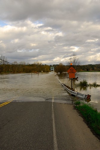
England has been hit by a lot of flooding, even washing bridges away. OpenStreetMap is there, keeping the map up to date by removing the bridges from the map:

England has been hit by a lot of flooding, even washing bridges away. OpenStreetMap is there, keeping the map up to date by removing the bridges from the map:
Where’s yours? Get one here!

See the article here.
“First they ignore you, then they laugh at you, then they fight you, then you win.” – Gandhi.
See story here.
The Prime Minister and Communities Secretary John Denham will today announce that the public will have more access to Ordnance Survey maps from next year, as part of a Government drive to open up data to improve transparency.
Speaking at a seminar on Smarter Government in Downing Street later today, attended by Sir Tim Berners-Lee and Professor Nigel Shadbolt, the Prime Minister will set out how the Government and Ordnance Survey, Great Britain’s national mapping agency, will open up its data relating to electoral and local authority boundaries, postcode areas and mid scale mapping information.
Ericsson labs have released an OSM library:
A couple of months ago we released support for OpenStreetMap maps for our Web Maps API and the Java ME version of the Mobile Maps API. We are now happy to release it for the Android version of our Mobile Maps API. Mobile Maps for Android with OpenStreetMap allows any developer to integrate the maps from the OpenStreetMap project into any Android application and have them rendered in the fast and dynamic Mobile Maps engine.
Check out this article over at SciAM:
It seems there’s an online community or social network for every facet of life these days. One area where this makes a lot of sense is in map-making, given how well locals know their own territory. This might explain why OpenStreetMap—a map of the world that can be edited by anyone with Web access—has expanded from 100,000 contributors in June to more than 180,000 (and claims to be adding 300 new mappers daily).
This is the current OSMF logo

and the OSMF has opened a competition for a new one. So get scribbling and submit your alternatives on the wiki over here.
These great commercials have got Verizon in a bit of trouble
Read the slashdot story.
There’s a good summary of LUG Radio Live 2009 over here including OSM happenings with a talk by Andy Robinson:
Andy Robinson, also known as “Blackadder”, is an active contributor to the OpenStreetMap (OSM) Project and is the current secretary of the OSM Foundation. OpenStreetMap is an open source project run by the OpenStreetMap Foundation, that is building free online maps, not based on any copyright or licensed map data. The OpenStreetMap maps are released under the Creative Commons Attribution Share Alike 2.0 license.