Author Archives: Richard Weait

New ways to see OpenStreetMap data

Two new tile sets are now featured on the OpenStreetMap.org site. The
Transport Layer and the MapQuest Open layer both use the same Hot
Fresh OpenStreetmap data that we all know and love. Each tile set
presents that data in a different way, for a different audience by
making careful choices about how to render OpenStreetMap data.

The Transport layer, courtesy of Andy Allan shows public
transportation infrastructure like subways and bus routes and train
stations.

Media_httpiimgurcomcz_eqasq

The MapQuest Open layer, courtesy of MapQuest shows highway shields and toll
roads.

Media_httpiimgurcomt9_fjfkm

Classroom OpenStreetMap workshop

OpenStreetMap contributor Ilya Zverez reports on recent OSM workshops
in Russian classrooms.

Recently there were three mapping lessons in small towns of Perm
region, Russia. It went very well, from collecting data to drawing
maps in Potlatch. At the last meeting they even tried to send a
weather baloon with a camera (but photos were no good because of
strong wind). Here is project page, in Russian, but google-translated:
http://translate.google.com/translate?hl=en&sl=ru&tl=en&u=http%3A%2F%2Fosm.pe…
Photos and reports are in the wiki, also in Russian. One of major TV
channels covered it: http://www.5-tv.ru/news/47596/

OpenStreetMap used by TripAdvisor

OpenStreetMap contributor Harry Wood tells us
about a new application.

TripAdvisor have launched a set of free android apps providing city
guides for 20 popular world cities, and for the maps they’ve used
OpenStreetMap!

Each of the following cities has a dedicated app on the android marketplace: Amsterdam, Barcelona, Beijing, Berlin,
Boston, Chicago, Florence, Hong Kong, Hawaii, Las Vegas, London,
Los Angeles, New York City, Orlando, Paris, Rome, San Francisco,
Sydney, Tokyo, and Washington D.C., and each one comes with
OpenStreetMap in a nicely themed green colour scheme.

TripaAvisor Adroid app showing OpenStreetMap

TripAdvisor.com is one of the
largest travel websites on the web. You may know them for their hotel
and restaurant listings with user reviews. These are all available
within the app, and overlaid on the maps (although it should be noted
that they’re not using OSM for the locations of these things, and in
places it looks like they could use a bit of iterative wiki-style
improvement to their accuracy!) but we’re delighted to see them
taking OpenStreetMap data and rendering it in their own style. The
maps are also available offline, allowing travellers to avoid data
roaming fees.

ODbL progress

We’re planning the final stages of the switch over to the Open Database License for OpenStreetMap data. The OpenStreetMap Foundation Board discussed the license upgrade process and many other aspects of the project at their recent board meeting, and we’ll have more information about that from the board shortly.

One item that came out of the board meeting was the deadline to complete the license upgrade by 01 April 2012 and to publish the first OpenStreetMap planet file under the ODbL by 04 April 2012. The License Working Group supports this target date as a reasonable goal.

There are still many things to do before we are ready to publish the first OpenStreetMap planet file as an ODbL database. As always, community engagement and your participation are important. There will be more information and details on your favourite OSM community channels including the mailing lists and IRC. For now the process of contacting mappers yet to respond and remapping non-compliant data is still the priority.

There are various tools to help you get an idea of ODbL coverage in your country, or your local area. In particular, you can enable a view within Potlatch2 or install a plugin for JOSM to see the license status of elements.

What’s new on OpenStreetMap.org?

Swan photo by Tony the Misfit is licensed CC-By

We spend a lot of time talking about the amazing map our users are producing, but perhaps not enough about the technology that enables it all. But it’s worth shouting about: from the reliable Ruby code that puts stuff into our super-efficient Postgres database setup, to the speedy hardcore cgimap code that sends it out to editors, to the wizardry of Mapnik that makes it all into beautiful maps… like the swan, there’s a lot of effort underneath the surface, but it all seems serene above water.

In fact, there’s a constant stream of changes aimed at making OpenStreetMap easier to use – big ones, yes, but also “little things that mean a lot”. So, for example, in the last month we’ve improved the “users near you” map (thanks to Martijn van Exel) and fixed potential security issues (thanks, as ever, to Tom Hughes). We’re also finishing up a move to Rails 3, which will help us make more user interface improvements, and keep the code clean. We’ll tell you more about these changes as they happen.

Have you noticed that osm.org adjusts to smaller screens with smaller tabs? It does now. Map CC-By-SA

Our Potlatch 2 editor has also had a whole bunch of improvements. It’s now much easier to draw shapes with holes (“multipolygons”), the GPS track handling is cleverer, and we have a clever feature where you can replace a node with a whole new one (select the old one and press O). We’ve incorporated a number of suggestions from usability research, and there’s still more to come.

If you’re a developer, we’d love to have your help with OpenStreetMap. There’s so much to do! You can find out about our codebase at http://wiki.openstreetmap.org/wiki/Rails, and join the rails-dev mailing list to bounce ideas off other developers. Or if you’d like to help with Potlatch 2, see http://wiki.openstreetmap.org/wiki/Potlatch and the potlatch-dev mailing list.

Tile Usage Policy

Tile image by vidalia_11 is licensed CC-By-SA

We’ve had to block some uses of the OpenStreetMap Foundation tile servers. This article describes what is happening and why. This article also describes how you can adapt if you are affected.

We’re really proud of the increased popularity of OpenStreetMap. We’ve seen seven-plus years of project growth in every measurable area. As the project has grown we’ve learned and adapted in many ways. The use of our tile server has grown faster than every other aspect of the project. One way that we are adapting now, is by restricting how our map tiles may be used.

Slow sign by DaveCrosby is licensed CC-By-SA

You’ll still be able to use our tiles in creative and interesting ways but the volume of use will be limited. We need to limit access to our tile server to only those users who don’t overburden our resources.

Those users who make large demands on our tile server will be slowed down by our throttling mechanism. This throttling mechanism is rarely triggered by mappers.

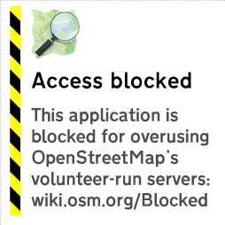
Problematic applications may show this image instead of a map.

Those applications which make exceptional demands in aggregate from their users will be blocked. The tile usage policy is on the OSM wiki.

So what can you do about this? How can you get the wonderful OpenStreetMap tiles for your mobile device?

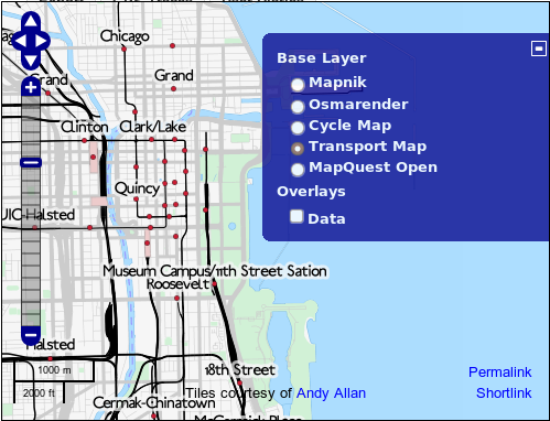
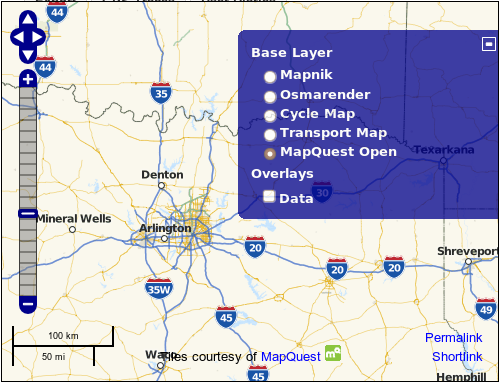
You’ll find more advice about potential tile source alternatives on the wiki.

Read on if you would like to know more about the history of the OpenStreetMap tile server.

OSM tile server background

We started creating rendered images of our map data as a way to encourage our data contributors. Mappers enjoy seeing the results of their surveys on the OpenStreetMap web site, and they can be inspired to map in their neighbourhood the things they see other mappers surveying in other places. Mappers loved the tile server when it first appeared. Potential users often looked at the map in 2006 and said, “Hey, why is there a huge blank spot where my town should be?” Some of those potential users became the long-time contributors that we all know and love.

As more contributors mapped more neighbourhoods, more blank spots started to fill in. More potential users became actual users, and OpenStreetMap tiles started to appear in more places. The tile server became even more popular when rapid updates were enabled. Rather than updating the map every week, parts of the map could update as contributors added data. If you remember the weekly updates you also remember that funny tingle you had the first time you mapped something and it appeared on the map immediately; it seemed like magic, didn’t it?

The OpenStreetMap Foundation has had a tile usage policy for some time. From September 2008 it has been explicitly stated that bulk downloading of tiles was discouraged. OpenStreetMap kept growing. More people came to understand the awesomeness of OSM tiles.

Also in 2008, the Ordnance Survey started serving map tiles to users through their OS Openspace program. In July of 2011, Ordnance Survey served their one billionth tile to a user.

OpenStreetMap serves a Billion tiles every eleven days.

So we know a thing or two about providing awesome maps to users. We do it all with the crowd-sourced data from our contributors around the world, the volunteered time of our sysadmins who keep our servers running, and the generous donations of servers and bandwidth and funds.

We’ve had to become more restrictive of the use of our tile server over time. We’ve limited how many tiles you can consume in a period of time. These restrictions only affected the most-demanding of tile consumers. The everyday mapper never ran into a problem getting tiles to add data to OSM. That allowed the growing number of users to continue to have access to OpenStreetMap tiles without our resources being monopolized by one or two bad actors.

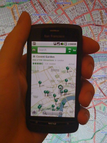
More and more mobile applications started using OpenStreetMap tiles. Many of them included a bulk downloading method so that tiles could be saved on the device at home, rather than downloading tiles at a punitive data rate. That bulk-downloading has always been problematic for OpenStreetMap because a single user will consume hundreds of times the resources of an average user. There are so many applications using OSM tiles, with so many users making unreasonable demands on our resources that it is affecting the quality of service for the average user. And that’s not fair.

So we’ve started blocking the applications that are causing us the most trouble, in addition to blocking users with problematic specific behaviours. We regret it, in a way. After all, we map because we want people to be able to use our data. But our resources have to be used in a way that everybody can share. We can’t have a small number of people consuming all of our resources.

So that’s why some people have started to see the “prohibited” tiles on their maps. Overuse. Or mobile applications that are causing overuse by a group.

Big Baseball Project 2011

To coincide with baseball playoffs and the World Series we’re running
a special mapping project:

The big baseball project!

Help adding baseball diamonds to OpenStreetMap. This is a really easy
type of map editing which anyone can get involved in, so give it a go,
and tell a friend! If you live in the U.S. (or some other baseball
fanatical part of the world) you can start by looking for baseball
diamonds near where you live, but these things are easy to spot in the
aerial imagery. This means everyone can help, from wherever you are in
the world. You can even contribute to the free world map while you’re
watching the MLB playoffs on TV!

We’re tracking baseball edits to bring you a rolling edits display and user rankings, but you’ve only got until
October 27th to become an OpenStreetMap baseball champion!

You’ll find more guidance on the wiki, plus a short press release.