The student application period for this year’s Google Summer of Code is currently open!
Are you a student who likes to code? Google Summer of Code offers you the opportunity to spend a couple of months contributing to an open source software project – such as OpenStreetMap – and get paid for it!
In 2019, OpenStreetMap has been selected again as a mentoring organization by Google, continuing eleven years of GSoC experience with many successful participants. Our project ideas page lists a variety of possible tasks which use a broad range of programming languages and technology stacks, and cover topics ranging from work on our search engine to editor software improvements. Plus, you’re not limited to that list of suggestions, so if you’d like to contribute to a project from the OSM ecosystem that’s not listed there, feel free to discuss it with us!
Some pointers for interested students:
Choose your (our!) organisation and project idea or even suggest your own idea!
Get to know your organisation and mentor
Apply and wait to see if you will get selected
Community bonding
Work hard on your project, pass evaluations
Don’t forget to document your code and project
Our project is big and we have a very broad and diverse set of tasks, and project ideas which require an equally diverse set of skills. But one thing is quite common to all of them: You should learn about our database and how mapping is supposed to be performed. So go out and start mapping! Add your local grocery store, your favorite clothes shop or that one bench you love to sit on. No matter what, it’s important to get yourself familiar with OpenStreetMap.
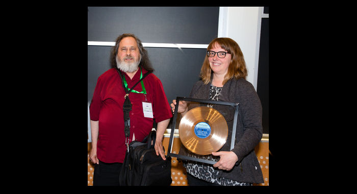
OpenStreetMap was selected as the winner of the Free Software Foundation 2018 Award for Projects of Social Benefit. FSF founder and president Richard Stallman – who presented the award during the LibrePlanet 2019 conference in Cambridge, MA – mentioned that:
“it has been clear for decades that map data are important. Therefore we need a free collection of map data. The name OpenStreetMap doesn’t say so explicitly, but its map data is free. It is the free replacement that the Free World needs.”
The award was a custom-made piece of art: a golden-looking record that had on its label the four reasons why OpenStreetMap was nominated. It was accepted on behalf of the OpenStreetMap community by Kate Chapman, who went on to thank the Free Software Foundation and the large community of OpenStreetMap contributors. Kate is the chairperson of the OpenStreetMap Foundation – which supports the OpenStreetMap project – and she presented some key milestones of the project during her Sunday talk
“The FSF’s Award for Projects of Social Benefit honors projects that have taken the ideals of the free software movement and applied them to intentionally and significantly benefit society in other aspects of life. OpenStreetMap’s use of free software, freely shared data, and international grassroots collaboration has massively benefited not only the daily lives of individuals around the world but also saved lives through humanitarian uses like improved disaster response. We all owe OpenStreetMap contributors a debt of gratitude, and the FSF is happy to show our appreciation through this award”, said FSF executive director John Sullivan.
Thanks to all those who contribute to the OpenStreetMap project – the award belongs to you!
2019-03-30 The post was updated to reflect that the award had on its label the four reasons why OpenStreetMap was nominated, and not the Free Software’s Four Freedoms, as initially mentioned.
What is OpenStreetMap OpenStreetMap was founded in 2004 and is a international project to create a free map of the world. To do so, we, thousands of volunteers, collect data about roads, railways, rivers, forests, buildings and a lot more worldwide. Our map data can be downloaded for free by everyone and used for any purpose – including commercial usage. It is possible to produce your own maps which highlight certain features, to calculate routes etc. OpenStreetMap is increasingly used when one needs maps which can be very quickly, or easily, updated, such as ambulance services, fire brigades and humanitarian crises response.
What is the OpenStreetMap Foundation The OpenStreetMap Foundation is a not-for-profit organisation, formed in the UK to support the OpenStreetMap Project. It is dedicated to encouraging the growth, development and distribution of free geospatial data for anyone to use and share. The OpenStreetMap Foundation owns and maintains the infrastructure of the OpenStreetMap project.
What is the Free Software Foundation The Free Software Foundation (FSF) is a nonprofit with a worldwide mission to promoting computer users’ right to use, study, copy, modify, and redistribute computer programs. The FSF promotes the development and use of free (as in freedom) software — particularly the GNU operating system and its GNU/Linux variants — and free documentation for free software.
What is LibrePlanet LibrePlanet is an annual conference hosted by the Free Software Foundation for free software enthusiasts and anyone who cares about the intersection of technology and social justice. LibrePlanet brings together software developers, law and policy experts,activists, students, and computer users to learn skills, celebrate free software accomplishments, and face challenges to software freedom.
A day of protests will take place in more than 30 cities all over Europe on 23 March. Please join a demonstration! Locations and dates.
The German OpenStreetMap community explains below the possible impacts of Article 13 of the new EU Copyright Directive on OpenStreetMap. Source: https://www.openstreetmap.de/uf/en.html (with minor modifications)
On 26 March 2019, the European Parliament will vote for a third time on the new EU Copyright Directive. Article 13 of the new directive will de-facto force content platforms to filter uploaded contributions by their users. If a platform does not prevent uploading of copyright-protected content in accordance with “high industry standards of professional diligence” (i.e. upload filters), the operator of the platform is liable for copyright violations of their users. The new rules can be met by the large platforms, such as Google, Youtube and Facebook. Small, independent and free platforms like OpenStreetMap would be forced to introduce such filters or face catastrophic liability. This threatens our project.
The European Parliament passed the bill on 12 September 2018 despite noticeable civil society protest. Since then, the European Commission, the Council of Europe and representatives of the parliament, negotiated a compromise. It is expected that the parliament will vote on the compromise in the last week of March. We think that passing the bill would harm the OpenStreetMap and many other small and medium-sized platforms – regardless of whether they are commercial or not. If OpenStreetMap had to invest more resources on pre-filtering content than on anything else, the project would be a shadow of its former self. If nothing changes, a dark future awaits us.
The OpenStreetMap Foundation,FOSSGIS e.V. – the official local chapter in Germany – and OpenStreetMap France – the official local chapter in France – campaign for free map data. We usually do so in financial and technical matters but sometimes we are forced to become active in politics to defend the project.
But the directive does not mention upload filters, does it?
The term is not used in the current version of the draft. But operators of platforms will be liable for copyright violations of their users if they do not meet the following conditions:
They must have made “best efforts” to get a licence to use the uploaded content.
They must have made best efforts to ensure that their platform does not publish content if copyright holders have provided them with the necessary information.
If they are informed about a copyright violation, they have to remove the content, or disable access to them, immediately.
Until now, platforms were excepted from strict liability if they reacted immediately to a notification of a copyright violation. This new directive would force platforms to use either upload filters or review all contributions manually. Upload filters are the “high industry standard of professional diligence”. For example, Google uses them on Youtube.
What’s the problem with upload filters?
Upload filters have a
number of issues for small and medium sized and/or free and independent
platforms like OpenStreetMap and Wikipedia:
These filters do not work as reliably as required. Even now, and definitely under the new directive, they tend to be too zealous, by erring on the side of caution and excluding more than they should.
The operators of small and medium sized platforms will be forced to purchase the filter technology from large companies to keep up with the current state of filtering technology. This gives more power, and money, to large companies, centralising their power even more.
The rules will affect any website where users can upload copyrighted content. These are not only social networks but blogs with comments and forums as well. Small and new platforms lack the required financial resources to buy the filters. They will be exempted from the first and second condition (attempt to get a license and prevent uploads of copyrighted contents) if their annual turnover is below EUR 10 million and they are less than 3 years old. But three years is a short time. If the number of users exceeds 5 million, condition 3 (prevent re-upload of illegal content) must be met.
The directive aims to oppose the business model of big US companies. Indeed, the business model of Google and others is not always well aligned with public interests, but the directive will harm small and medium sized competitors, not the large ones.
Why do upload filters harm OpenStreetMap?
The OpenStreetMap project emphasises openness. Map changes by all users, new and experienced, are applied immediately and are provided to all other data processors immediately. The map is always as up to date as possible.
Upload filters are very impracticable for multiple reasons:
OpenStreetMap records the reality as it is. Other map data providers do the same. If OpenStreetMap compared the submissions with other datasets, many false positives would occur. Our data is if it is correct, very similar to the data of other map providers. A road in OpenStreetMap has the same curves, the same name, the same speed limit.
If a user uploads changes which are rejected by a filter, these changes have to be rejected as soon as possible. This requires the time of our volunteers, who would like to improve the map rather than checking whether a filter returned a false positive.
If a rejected contribution and a contribution of another user edit the same object in the database, a editing conflict occurs. They cannot be solved automatically because our world is too complex. Some conflicts are not that obvious: If two users add the same recently erected building, the two of them create a new object. In reality, this is a building recorded twice in our data.
If an edit by a new contributor is rejected by the filter although the edit is fine, the contributor becomes demotivated due to a lack of positive feedback.
The development, setup and optimisation of the filter requires a large amount of work from our volunteer software developers. Maybe we will have to spend money to purchase services. Both the work of our volunteers and the donations and membership fees are precious limited resources which can be better spent elsewhere to take our project forward.
There is an exception for Wikipedia, isn’t there?
It is not clear whether the “Wikipedia exemption” would be valid for OSM and even Wikipedia does not feel confident: María Sefidari Huici, member of the board of Wikimedia Foundation, calls the proposed changes a threat for the living and free internet. The Wikimedia Foundation, the organisation behind Wikipedia, doubts that this exemption satisfies their requirements. We share these doubts.
The directive has to be implemented in national law by EU member states. The implementation will not be the same among the countries. Some differences are possible. In some countries, terms like “commercial” and “business-like” are interpreted very strictly. Our data is used in commercial environments a lot. There are many companies using our data and contributing back to OpenStreetMap by developing software or paying their own data contributors – or just by making OSM available to the broad public. If OpenStreetMap becomes harder to use for commercial data purposes, due to these new restrictions, it will harm all of us.
What can I do to oppose the directive?
There are multiple options to become active:
Sending emails to MEPs is not useful or effective. It is likely that would be treated as spam and/or boost the (false) impression put forward by some advocates of the directive that the folks against the directive are “Google’s bots”.
Our number one request is that you join a protest. Join one of the many demonstrations or organise one yourself. There is a day of action in more then 30 cities all over Europe on 23 March. Dates and locations can be found at savetheinternet.info.
The web site saveyourinternet.eu provides suggestions and support to get in touch with members of the European Parliament. If we succeed in explaining to enough MEPs that upload filters as described in article 13 are a bad idea, the Parliament can reject the article or the whole proposal.
Press contact
Enquiries can be answered by the Communication Working Group at press@osmfoundation.org. As the Working Group members are volunteers, we invite you first to use your favorite search engine to see if your question has been answered in our forum or mailing lists. You can also ask your questions on the forum (OpenStreetMap account required for log-in), our mailing lists and in our chat rooms.
What is OpenStreetMap OpenStreetMap was founded in 2004 and is a international project to create a free map of the world. To do so, we, thousands of volunteers, collect data about roads, railways, rivers, forests, buildings and a lot more worldwide. Our map data can be downloaded for free by everyone and used for any purpose – including commercial usage. It is possible to produce your own maps which highlight certain features, to calculate routes etc. OpenStreetMap is increasingly used when one needs maps which can be very quickly, or easily, updated, such as ambulance services, fire brigades, humanitarian development and humanitarian crises response.
What is the OpenStreetMap Foundation The OpenStreetMap Foundation is a not-for-profit organisation, formed in the UK to support the OpenStreetMap Project. It is dedicated to encouraging the growth, development and distribution of free geospatial data for anyone to use and share. The OpenStreetMap Foundation owns and maintains the infrastructure of the OpenStreetMap project.