If you head over to OpenStreetMap.org and click on the layers button on the right of the map, you are provided a selection of map layers to choose from. This is possible due to the nature of OpenStreetMap – by distributing open geographic data we enable others to produce a map from OpenStreetMap data in whatever style they require. The OSM website provides five such styles but there are many hundreds, if not thousands of other styles in use across the web.
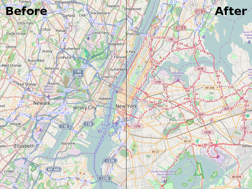
We will shortly begin to roll out a new version of the ‘Standard’ (or default) map style replacing the current version. Although the new version is an evolution of the existing version, the changes to road colours and the display of railways will significantly help to improve the readability of the map. During this roll out you may see a patchwork of old and new map style for a few hours – please be patient whilst our servers work hard to update all corners of the map.
How will the style change?
The change of the map style will primarily effect the way roads and railways are displayed. As OpenStreetMap has grown over the last 11 years we have began to collect more and more information about our surrounding environment. The standard map style has adapted to display this information, but over time this has led to the road and rail network becoming harder to identify. For example, trunk roads (currently shown in green) can be very hard to see in heavily forested areas.
In the new map style “road colours [are] tuned to ensure that roads are well visible on all landcovers”, explains Mateusz Konieczny, who has developed the new style (project details) . Mateusz has worked with the OpenStreetMap community at every step of the journey from initial research to draft implementations to gather feedback on the design. He adds that “steady progression of hue and lightness for major road types (motorway, trunk, primary, secondary, tertiary) should make more intuitive which roads are more important”.
There’s been other recent changes to the style – why highlight this one?
You’re right. For the last few years there has been a new map style released every two to three weeks. As with all things OpenStreetMap there is an army of volunteers working to fix and improve the map style. It would be great to write about all of them but that’s simply not possible. So this change, being one of the larger ones and a Google Summer of Code project, gives us a great opportunity to pause and thank all those who have contributed to the map style. Thank you style maintainers!
What next for this map style?
In the short term, it’s likely to be small incremental tweaks so as to continuously improve the map. Every big change attracts new style maintainers who bring their own ideas and experience. There may be a few minor tweaks to the paths and roads based on their ideas.
There is also an updated version of Mapnik, the underlying toolkit used to convert the written style rules in to the final map you see on the OSM website. The latest version will help to fix a lot of bugs related to non-latin scripts/languages. In the longer term there is the option to repopulate the database used by the Standard map style so that it has access to all OpenStreetMap data tags, not just a limited few.
Can I help with development of the ‘Standard’ style?
Yes. The standard map style, which is known as OpenStreetMap-Carto is available on GitHub. Andy Allan, who re-energized the development of this map style in 2012 has given a number of talks at recent OpenStreetMap conferences. Two good starting points are his talk at State of the Map US 2015 in which he gave a progress update for the project, and the detailed workshop he ran at State of the Map EU 2014.
And what about the other map styles?
Well this change only affects the ‘Standard’ (or default) layer as seen on openstreetmap.org.
There are a number of alternative map styles available or you could make your own. Perhaps you want to produce your own personal map to highlight features that are important to you, or maybe you want the map to better match your company brand. This is all possible with OpenStreetMap data. You can even take the current ‘Standard’ as a starting point.
Is it possible to add new map styles to the OSM website?
It is possible, although your style (and the hosting of it) must meet a number of criteria to be considered. See our tile layer guidelines.


