Monthly Archives: February 2012

Help find who killed Ulf

We had sad news in January that our friend Ulf had been murdered in
Germany. Ulf’s family have asked if we can help find those who
murdered Ulf? Please see the up-to-date reports, and photos of
suspects:

http://ulf-m.blogspot.com

And please circulate. Help find Ulf’s killer(s).

We’re asking for the OSM community’s help. The people who
killed Ulf haven’t been found yet, very probably because they left the
country the morning after the crime. East European mappers, especially
from Lithuania or Poland, might have seen them, or they might at least
know about message boards in their language where the pictures and
description can be posted.

At http://ulf-m.blogspot.com, there are now English, Lithuanian and
Russian language versions, a Polish Version will follow. We are
thankful for any help in circulating our appeal in any appropriate
form.

Weekly OSM Summary #36

January 30th, 2012 – February 13th, 2012

A summary of all the things happening in the OpenStreetMap (OSM) world.

  • The “License Change View” of the OSM Inspector is updated every four hours now.
  • Several OSM Users reported that the Bing aerial imagery has been updated or that new images have been added. Read more here.
  • OSM data and Garmin GPS Maps for Syria generated on an hourly basis are available now. Based on the Bing aerial imagery you can add missing streets.
  • A Hack Weekend will take place in March in Toronto. Get more information here.
  • Belarus has a new OSM Project page now too: openstreetmap.by
  • Some OSM users noticed that several military areas in Germany are now masked in the German Bing aerial images. According to Steve Coast, a German agency requested this.
  • The Tiles @ Home server will be shut down by the end of February 2012. A big thank you for hosting this service in the past! Read the full announcement here.
  • A new JOSM-Plugin speeds up the download time of OSM data. Read more about it here.
  • On OSMRanking you can create daily updated rankings based on your edits in the OSM database. You can find an example of the “Members of the OSM Foundation Board” here.
  • Steve Kay created an OSM Tag Network of Edinburgh.
  • Lanyrd.com shows upcoming events on an OSM Map now. For instance the German FOSSGIS & OSM Conference 2012 in Dessau
  • With Active.com and Toursprung two additional websites switched from Google to OpenStreetMap.
  • A video of Patrick Meier’s presentation about “Crisismapping” at the re:publica XI: “Changing the World, One Map at a Time“. Also, a video of a presentation by Richard Cantwell at the Ignite Dublin about OSM and in particular about Haiti can be found here.
  • Around the Alps in 80 days“ a mapping project for the summer of 2012.
  • A nice Blog Post about “OpenStreetMap Philippines: 2011 Year in Review” by Eugene Alvin Villar.
  • An iOS App for OpenSeaMap is available now.

Did we miss something? You can contact us via weekly.osm@googlemail.com

Authors: Pascal & Dennis – (thx @ “Wochennotiz”)

Contact and Remap

A message from Michael Collinson and the Licensing Working Group


“Hi everyone,

We ask OSM mappers to check their local mapping areas, try and contact anyone who has not decided about re-licensing and then do as much remapping as you can. Please do this in good faith and not just copy things created by contributors who have declined or undecided! You can use information contributed by continuing mappers, resources like Bing imagery and your own knowledge. If you are mapping in Poland or the Czech Republic, please also note that we are aware of special issues that makes this difficult for you right now.

We would like to switch over licenses in two months time. In order to do that, un-relicensable data has to be removed from the active database, though it will remain in publicly available archives. The latest indications are that 1.9% of ways will likely not survive the license change and a further 0.6% may have to be reverted back to an earlier state.

We would like to decrease that still further.


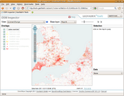
Your mapping area may be much worse or much better. You can use the license change view on OSMinspector and zoom into your area (Information on this tool). You can then click on Potlatch or JOSM icons to find out more and to do remapping. More info

We ask that you look at your areas and contact undecided mappers via the OpenStreetMap messaging system or directly if you know them. So that they do not get bothered too many times, please log who you contacted on this wiki page

This page also has example messages in different languages. Ask undecided mappers to please log into their account and accept even if they no longer wish to continue mapping as their previous contribution is important to you. Contact from someone mapping in the same area is very useful.”


The text of this posting can also be found at Remapping/Contact And Remap Campaign. Please feel to simplify it to help non-native English speakers and to translate it into other languages.

Original mailing list post

Weekly OSM Summary #35

January 16th, 2012 – January 30th, 2012

A summary of all the things happening in the OpenStreetMap (OSM) world.

  • On Tuesday, Feb. 7th, 2012 the Night of the Living Maps will take place. It is a global Mapathon. Get more information here.
  • The new webpage http://switch2osm.org is online! It helps you to switch your application to OSM (go figure). Ushahidi also uses OSM as their basemap now.
  • The License Working Group (LWG) wrote about the license change here and a new mailing list for the “Remapping Process” has been created.
  • The design and layout of the Humanitarian OpenStreetMap Team (H.O.T.) webpage has been updated. Also, a HOT presentation by Richard Welty can be found online here.
  • On February 25th and 26th a Hacking Weekend will take place in Karlsruhe, Germany.
  • With MapBox light a new online service has been published to use OSM maps for the visualization of different data. Read more here. Also, a minimalist OSM baselayer for MapBox.
  • A map of Ireland showing hospital accessibility using an OSM basemap and Flex.
  • Summary of all Stamen Maps which were created in 2011 based on free geodata.
  • Andy Allan created a new Snapshot Server. It is a new and simple solution to use OSM data in overlays.
  • An Open Source iOS App has been published. Read more here.
  • An article explaining how to use R or more specifically the Maptools library instead of ArcMap. You can use the osmar package in R too.
  • The new Red Sea volcanic island of the Zubair Group is already digitized in OSM.
  • Want to create your own OSM key fob? Watch this.
  • An article about OSM in Bangladesh.

Did we miss something? You can contact us via weekly.osm@googlemail.com

Authors: Pascal & Dennis – (thx @ “Wochennotiz”)