
Longtime OpenStreetMap contributor Balrog-kun is featured and quoted
in this article about OpenStreetMap in the Warsaw Gazette. The article was on the
front page of the print version of the newspaper on 05 November 2011.
Longtime OpenStreetMap contributor Balrog-kun is featured and quoted
in this article about OpenStreetMap in the Warsaw Gazette. The article was on the
front page of the print version of the newspaper on 05 November 2011.
October 17th, 2011 – October 31th, 2011
A summary of all the things happening in the OpenStreetMap (OSM) world.
Did we miss something? You can contact us via weekly.osm@googlemail.com
Authors: Pascal & Dennis – (thx @ “Wochennotiz”)
Tile image by vidalia_11 is licensed CC-By-SA
We’ve had to block some uses of the OpenStreetMap Foundation tile servers. This article describes what is happening and why. This article also describes how you can adapt if you are affected.
We’re really proud of the increased popularity of OpenStreetMap. We’ve seen seven-plus years of project growth in every measurable area. As the project has grown we’ve learned and adapted in many ways. The use of our tile server has grown faster than every other aspect of the project. One way that we are adapting now, is by restricting how our map tiles may be used.

Slow sign by DaveCrosby is licensed CC-By-SA
You’ll still be able to use our tiles in creative and interesting ways but the volume of use will be limited. We need to limit access to our tile server to only those users who don’t overburden our resources.
Those users who make large demands on our tile server will be slowed down by our throttling mechanism. This throttling mechanism is rarely triggered by mappers.
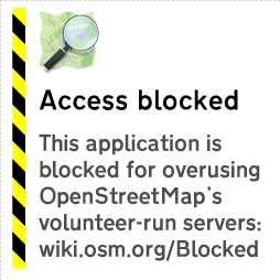
Problematic applications may show this image instead of a map.
Those applications which make exceptional demands in aggregate from their users will be blocked. The tile usage policy is on the OSM wiki.
So what can you do about this? How can you get the wonderful OpenStreetMap tiles for your mobile device?
You’ll find more advice about potential tile source alternatives on the wiki.
Read on if you would like to know more about the history of the OpenStreetMap tile server.
We started creating rendered images of our map data as a way to encourage our data contributors. Mappers enjoy seeing the results of their surveys on the OpenStreetMap web site, and they can be inspired to map in their neighbourhood the things they see other mappers surveying in other places. Mappers loved the tile server when it first appeared. Potential users often looked at the map in 2006 and said, “Hey, why is there a huge blank spot where my town should be?” Some of those potential users became the long-time contributors that we all know and love.
As more contributors mapped more neighbourhoods, more blank spots started to fill in. More potential users became actual users, and OpenStreetMap tiles started to appear in more places. The tile server became even more popular when rapid updates were enabled. Rather than updating the map every week, parts of the map could update as contributors added data. If you remember the weekly updates you also remember that funny tingle you had the first time you mapped something and it appeared on the map immediately; it seemed like magic, didn’t it?
The OpenStreetMap Foundation has had a tile usage policy for some time. From September 2008 it has been explicitly stated that bulk downloading of tiles was discouraged. OpenStreetMap kept growing. More people came to understand the awesomeness of OSM tiles.
Also in 2008, the Ordnance Survey started serving map tiles to users through their OS Openspace program. In July of 2011, Ordnance Survey served their one billionth tile to a user.
OpenStreetMap serves a Billion tiles every eleven days.
So we know a thing or two about providing awesome maps to users. We do it all with the crowd-sourced data from our contributors around the world, the volunteered time of our sysadmins who keep our servers running, and the generous donations of servers and bandwidth and funds.
We’ve had to become more restrictive of the use of our tile server over time. We’ve limited how many tiles you can consume in a period of time. These restrictions only affected the most-demanding of tile consumers. The everyday mapper never ran into a problem getting tiles to add data to OSM. That allowed the growing number of users to continue to have access to OpenStreetMap tiles without our resources being monopolized by one or two bad actors.
More and more mobile applications started using OpenStreetMap tiles. Many of them included a bulk downloading method so that tiles could be saved on the device at home, rather than downloading tiles at a punitive data rate. That bulk-downloading has always been problematic for OpenStreetMap because a single user will consume hundreds of times the resources of an average user. There are so many applications using OSM tiles, with so many users making unreasonable demands on our resources that it is affecting the quality of service for the average user. And that’s not fair.
So we’ve started blocking the applications that are causing us the most trouble, in addition to blocking users with problematic specific behaviours. We regret it, in a way. After all, we map because we want people to be able to use our data. But our resources have to be used in a way that everybody can share. We can’t have a small number of people consuming all of our resources.
So that’s why some people have started to see the “prohibited” tiles on their maps. Overuse. Or mobile applications that are causing overuse by a group.
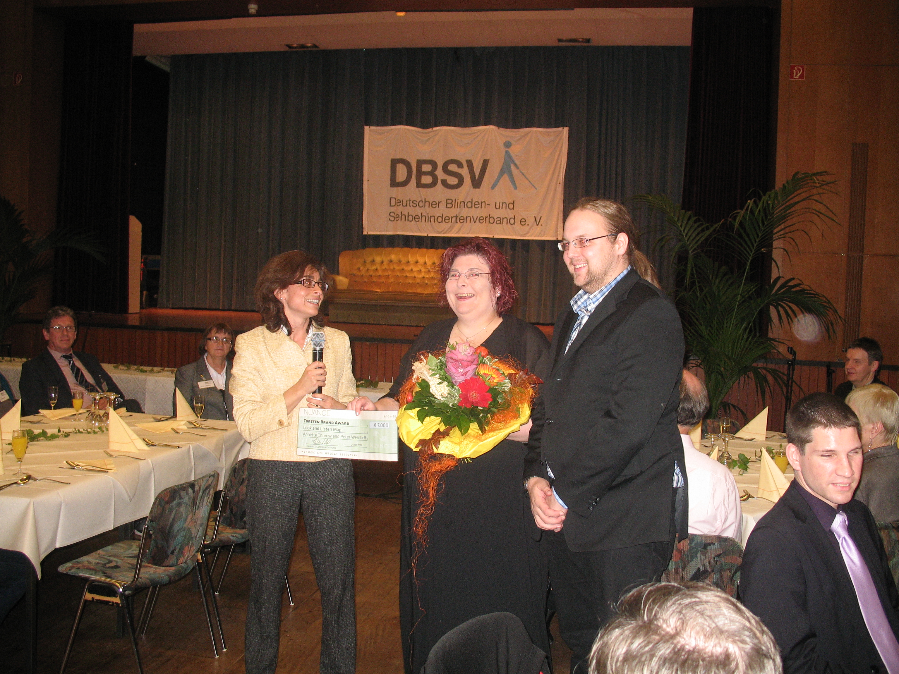
Congratulations go to OpenStreetMap contributors Annette Thurow and
Peter Wendorff for their project, Look and Listen Map. They won the inaugural Torsten Brand Award. The
Torsten Brand Award recognizes advancements in access to information
and communication for low-vision and blind users through practical
interaction with technology.
Read the full press release.
October 5th, 2011 – October 17th, 2011
A summary of all the things happening in the OpenStreetMap (OSM) world.
Did we miss something? You can contact us via weekly.osm@googlemail.com
Authors: Pascal & Dennis – (thx @ “Wochennotiz”)
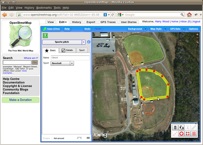
To coincide with baseball playoffs and the World Series we’re running
a special mapping project:
Help adding baseball diamonds to OpenStreetMap. This is a really easy
type of map editing which anyone can get involved in, so give it a go,
and tell a friend! If you live in the U.S. (or some other baseball
fanatical part of the world) you can start by looking for baseball
diamonds near where you live, but these things are easy to spot in the
aerial imagery. This means everyone can help, from wherever you are in
the world. You can even contribute to the free world map while you’re
watching the MLB playoffs on TV!
We’re tracking baseball edits to bring you a rolling edits display and user rankings, but you’ve only got until
October 27th to become an OpenStreetMap baseball champion!
You’ll find more guidance on the wiki, plus a short press release.

OSM Inspector is a quality evaluation service that was created by GEOFABRIK. It draws attention to
potential errors in OpenStreetMap data so that mapper can inspect them
and if needed, repair them.
This tutorial shows you how to include OSM Inspector in your mapping
and includes instructions for JOSM and Potlatch2.
September 19th, 2011 – October 4th, 2011
A summary of all the things happening in the OpenStreetMap (OSM) world.
Did we miss something? You can contact us via weekly.osm@googlemail.com
Authors: Pascal & Dennis – (thx @ “Wochennotiz”)
OpenStreetMap has always made geographic data available for use in
interesting and unexpected ways. As OpenStreetMap grows, the data
becomes more difficult for some users to consume purely because of the
volume of data.

To have the whole World in your hand, download and use the planet file.
Planet files are published every week. As mentioned above, some uses
find this file large and cumbersome to deal with, especially if their
interest is limited to a small portion of the data set.
In September 2011, the planet file was 18GB when compressed and about
250GB when loaded into a spatial database.
If your interests are limited to a portion of the planet, then you’ll
want to know more about planet extracts. Extracts are a portion of the OpenStreetMap data
set.

Extracts are provided by third-parties for single countries and and
also for regions that range from cities to states, provinces and
continents.

State of the Map 2011 group photo
The fifth annual OpenStreetMap conference, State of the Map
, wrapped up in Denver, Colorado recently. Even if you were not able to join the fun in Denver, you can still enjoy parts of the event. Conference sessions were recorded by our friends at FOSSLC and many of those recordings are already available. You’ll also find audience video for some of the sessions.
If we were tagging SotM11 to add it to the OSM database, we might consider tags like:
The call for venues for State of the Map 2012 is expected in November 2011. The SotM 2012 venue will be announced early in 2012.