Monsoon flooding continues in Pakistan following what has been called
the heaviest rains in 80 years. As many as 12 million people have
already been affected and over 1600 are known dead to date. The
availability of up to date aerial imagery has been hampered by the
continuous cloud cover. New flood warnings are announced often, and
the rains are continuing. Lists of dead and missing, additional
flooding, displacements and injury seem overwhelming. It is expected
that disease will become a very serious issue as access to clean water
is reduced.
http://www.thenews.com.pk/top_story_detail.asp?Id=30580
http://www.csmonitor.com/World/Asia-South-Central/2010/0806/Pakistan-floods-d…
http://www.bbc.co.uk/news/world-south-asia-1088
http://www.earthtimes.org/articles/news/338523,relief-efforts-summary.html9925
OpenStreetMap has some data in some of the affected areas. You might
help by donating money to an international relief agency. And you
might help by participating in mapping the flooded areas from aerial
imagery.
http://wiki.openstreetmap.org/wiki/2010_07_Pakistan_Floods
http://wiki.openstreetmap.org/wiki/2010_07_Pakistan_Floods/Mapping_Coordinati….26_Towns
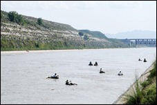
Photo from The News, http://www.thenews.com.pk/top_story_detail.asp?Id=30580
Additional pre-flood aerial imagery is now available. http://wiki.openstreetmap.org/wiki/2010_07_Pakistan_Floods/Imagery_and_data_sources
please put some long term affects on here
i like trains.