Monthly Archives: June 2010

State of the Map 2010 – more updates

Media_httpiimgurcomvu_gecjf

There is still time to register for State of the Map 2010 in Girona, Spain.
http://stateofthemap/register/

You’ll want to be there to:

Participate in, and enjoy the Concert Contest.

Who will get us all dancing with their rendition of Where the Streets
Have No Name and who will have us rolling in the aisles with My
Girona? Add yourself to the wiki page now to put yourself on the
concert schedule, or to join the OpenStreetBand to back up the other
performers.
http://wiki.openstreetmap.org/wiki/State_Of_The_Map_2010/Concert_Contest

You’ll also want to have a look at the videos on the State of the Map site.
http://stateofthemap.org/

More sponsors are showing their support for OpenStreetMap

Silver Sponsors:

Media_http2010stateof_yxcni

http://www.icc.es/

Media_http2010stateof_nkdei

http://www.ulmon.com/

Media_httpstateofthem_ycjbt

http://www.nogago.com/

Data Partner:

Media_httpstateofthem_fisxr

http://www.girona.cat/

Project of the Week: Fireworks!!!

It is fireworks season in North America, with both Canada Day and
Independence Day coming up this week. But where are the good places to
go to see fireworks displays?

This week’s project is to map your local fireworks locations. It may
be a waterfront park or other public space. Add those places to the
map where people collect to celebrate and observe the celebration of
holidays.

Find out more about this project of the Week, including tagging suggestions
http://wiki.openstreetmap.org/wiki/Project_of_the_week/2010/Jun_27

Make a suggestion or submit a guest Project of the Week
http://wiki.openstreetmap.org/wiki/Project_of_the_week/Proposals

Fireworks photo by spatulated http://www.flickr.com/photos/joshuarothhaas/
licensed ccby http://creativecommons.org/licenses/by/2.0/deed.en_CA

State of the Map 2010 – Exciting updates

Media_httpiimgurcomvu_itsvc

There is still time to register for State of the Map 2010 in Girona, Spain.
http://stateofthemap.org/register/

You’ll want to be there to:

Find out about the latest developments in the OpenStreetMap world
Get tips on using OpenStreetMap data and tools in your projects
Relax and socialize in a friendly atmosphere with like minded mappers
from around the world

Mapnik ( http://mapnik.org ) and OpenAerialMap (
http://openaerialmap.org ) workshops will be held on Friday 9 July
2010

More sponsors are showing their support for OpenStreetMap

Silver Sponsors:

Media_httpstateofthem_fgthn

http://newschallenge.org

Media_http2010stateof_qiutg

http://www.spotimage.com/

Bronze Sponsor:

Media_http2010stateof_zfhzd

http://www.nutiteq.com/

Workshop Partner:

Media_httpstateofthem_nibdw

http://www.sigte.udg.edu/sigte_en/sigte

Media Sponsor:

Media_httpstateofthem_cdock

http://lwn.net/

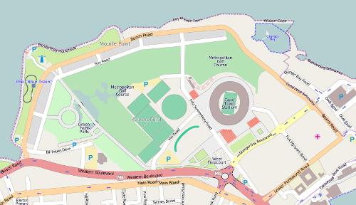
Image of the Week: Green Point Common

Media_httpimgurcom3ul_hwfbl

This map of Green Point Common was created from OpenStreetMap project
data, collected by the community.

Green Point Common in Cape Town, including the new Cape Town Stadium, one of the venues of the 2010 FIFA World Cup. See also the 2010 World Cup mapping project.

http://wiki.openstreetmap.org/wiki/WikiProject_South_Africa/Soccer_2010_Map

See the original image here
http://wiki.openstreetmap.org/wiki/File:Green_Point_Common_OSM.svg

This OpenStreetMap image is licensed ccbysa
http://creativecommons.org/licenses/by-sa/2.0/

Project of the Week: Translation: Now You Are Speaking My Language

There are OpenStreetMap contributors in many countries. They map many
roads and speak many languages. The Project of the Week is to
translate countries, states, provinces and cities for as many
languages as possible. This means that single language maps will be
practical in more languages. Perhaps we’ll never have OpenStreetMap
rendered in the original Klingon, or perhaps we’ll have that before we
complete the country translation in Cymraeg

So calling all multi-lingual OpenStreetMap contributors, or
uni-lingual OpenStreetMappers and your multi-lingual friends and
family. Come one, came all and make the map better for more people.
Which languages can be translation-complete in OpenStreetMap? Which
countries will be completely translated in OpenStreetMap. Is this a
chance for you to do some mapping with a family member from The Old
Country?

How well are the languages that you speak already represented in
OpenStreetMap?

For example:

Cymraeg is shown as translated for 204 of 226 countries or 90% complete.

ᐃᓄᒃᑎᑐᑦ / inuktitut is shown as translated for 8 of 226 countries or
3.5% complete.

Find out how to help with this Project of the Week and where to find
the tools that make this simple!

http://wiki.openstreetmap.org/wiki/Project_of_the_week/2010/Jun_20

Make suggestions or submit your project of the week.

http://wiki.openstreetmap.org/wiki/Project_of_the_week/Proposals

Crowd photo by Wayne Large http://www.flickr.com/photos/havovubu/
is licensed ccbynd http://creativecommons.org/licenses/by-nd/2.0/deed.en_CA

Wolfram Alpha is using OpenStreetMap data

Media_httpimgurcomdx7_jtafi

Frank Sautter reports on osm-talk that Wolfram|Alpha is using
OpenStreetMap data.

So if you search for, Girona, as in the example above, their reply
includes a map based on OSM data, like below.

Media_httpimgurcomybx_bvnis

So why would you search for “Girona” on Wolfram|Alpha? Because Girona
is where State of the Map will be held in just a few short weeks. You
really should attend. It will be informative and fun. And it will be
both in large measures.

Register now for State of the Map

http://stateofthemap.org/register/

The importance of timing to feedback

Short feedback cycles are important.

If you edit in openstreetmap you pretty much instantly see your data up there. You can download it again, as can others. It’s instantly integrated. Some things lag a little, you may have to wait a minute for the tiles to be rerendered correctly and maybe your browser cache needs a flush, but we’re about there.

When you have a short feedback cycle, it means that your users get a little drop of serotonin. That makes them happy. It’s simple action and reaction. You get frustrated with your phone when it freezes momentarily because you’re losing the feedback you expect. When you get feedback in a creative process like making a map it makes you want to map more. It’s addictive.

Consider then the antithesis. I just got an email from Wolfram Alpha, a very fun site, about feedback I gave about a year ago.

Google Maps is similar. If you click the little ‘report problem’ button then you might get an email in 3-6 months that it’s been fixed. Perhaps that’s why Google has recently decided to hire 300 people – to close that loop a bit.

I say that’s dumb. Get the hell out of my way. I don’t need an appointed faceless employee somewhere to tell me what a good job I did 3 months after I did it. That falls on deaf ears if for no other reason than I’ve totally forgotten about it. Of course, if I get feedback quickly from a real human being then that can be very powerful.

Mahalo does this. Or at least used to. If you sign up then multiple hip, perky 20-somethings will ‘friend’ you very quickly and tell you how to get more involved. That comes across as either automated (and thus fake) and too much too soon (and thus fake).

So you need a balance in terms of timing, depth and breadth of feedback.

Waze and Google MapMaker introduce a few layers to try and help. Instead of submitting to an anonymous employee, you submit to a faintly anonymous area manager. This sidesteps the cost issue but not really the feedback issue. They take just as long to respond and don’t have the same incentive to be nice to you that an employee might.

L.A. Times: Digital map of the world is the product of a large-scale volunteer effort

Media_httpimgurcom5m8_dhghj

OpenStreetMap user “Beej” is quoted widely in the L.A. Times article
on OpenStreetMap.

Digital map of the world is the product of a large-scale volunteer effort
With the help of more than 240,000 volunteer cartographers worldwide,
OpenStreetMap is trying to create an Internet map of every street in
every city and village on the planet.
June 09, 2010|By Mike Swift

SAN JOSE, Calif. — — When Brian “Beej” Hall first heard
about an ambitious volunteer effort to create an Internet map of every
street and path in every city and village on the planet, he was
hooked. At the time, the nascent effort had only a few American
members, and the U.S. map was essentially a digital terra
incognita.

Read the whole article here:

http://articles.latimes.com/2010/jun/09/business/la-fi-digital-maps-20100609