Monthly Archives: December 2009

Meteor Mapping

800px-Meteor_Crater_-_Arizona

Metero Crater is the well-named meteor crater in Arizona created by a “nickel-iron meteorite about 50 meters (54 yards) across, which impacted the plain at a speed of several kilometers per second. The speed of the impact has been a subject of some debate. Modelling initially suggested that the meteorite struck at a speed of up to 20 kilometers per second (45,000 mph), but more recent research suggests the impact was substantially slower, at 12.8 kilometers per second (28,600 mph). It is believed that about half of the impactor’s 300,000 tonnes (330,000 short tons) bulk was vaporized during its descent, before it hit the ground.[7]”

I drove the 3 hours there, then 3 hours back to visit it from Phoenix, Arizona yesterday and took some pics:

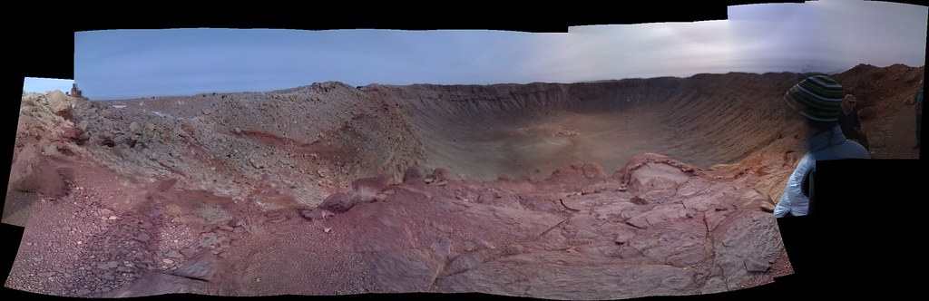
And of course I mapped it. There are a bunch of footpaths, a subway fast food restaurant, lookout points and so on. Of course someone had already mapped the crater rim and the car park. Check out the map here.

License Working Group podcast

As many of you will have seen the OSM project is in the midst of shifting license due to problems with Creative Commons applicability to data. You can read why here, here and here. There has been a lot of discussion on the mailing lists about this and with any license debate in an open project a lot of FUD. Today Matt Amos and Mike Collinson, members of the LWG together with Peter Batty, Richard Fairhurst and myself produced a podcast which covers many of the issues. To discuss more please feel free to comment on this post or join the legal mailing list where this has been discussed approximately 9 billion times over the last 2 years.

Map Editors Comparison

Matt has an interesting post comparing Map Editors:

I’ve been playing with the changeset data for OpenStreetMap and looking to see what patterns I can find in the usage of various editors since changesets were introduced in the API 0.6 migration. We can start off just looking at the major editors by distinct users, i.e: everyone’s favourite popularity contest.

Ian White’s panel at Nav&Loc

Yesterdays closing panel, which overran substantially, was great. Bordering on hilarious. The panel included Christian Petersen of CloudMade, Darren Koenig from TeleAtlas and Duncan McCall of Public Earth. Podcast is here. Best quality I could get with my laptop mic.

OpenSlumMap

Mikel parachuted in to Kibera last month – a holiday destination known as the “second largest urban slum in Africa” – to make sure it’s all mapped. The results have been impressive:

Untitled

It includes a website, map data of course and social media including twitter and interviews:

The press release is worth a read:

Kibera remains a blank spot on the Kenyan map, though it holds as many as one million inhabitants according to UN-HABITAT. Its limited health and water resources, traffic patterns, and housing layouts remain largely invisible to the outside world and to residents themselves. Though many organizations have collected data on Kibera, the information is not yet shared as a resource for all to use. Map Kibera will fill in this gap by producing free, open-source digital map data using the techniques of OpenStreetMap, a user-edited map of the world. The resulting information will be freely available to residents, NGOs, private companies, and others interested in working with and for Kibera.